Are you interested in spending your next vacation or day outing at the Lake Lure? Before you visit the Lake Lure, you need to plan your visit accordingly. That’s because you can discover so many activities to do at Lake Lure. Hence, you will get overwhelmed by the different options available. To help you with planning, we thought of sharing a list of the best Lake Lure water activities that you can try at the Lake Lure.
1. Sliding Rock
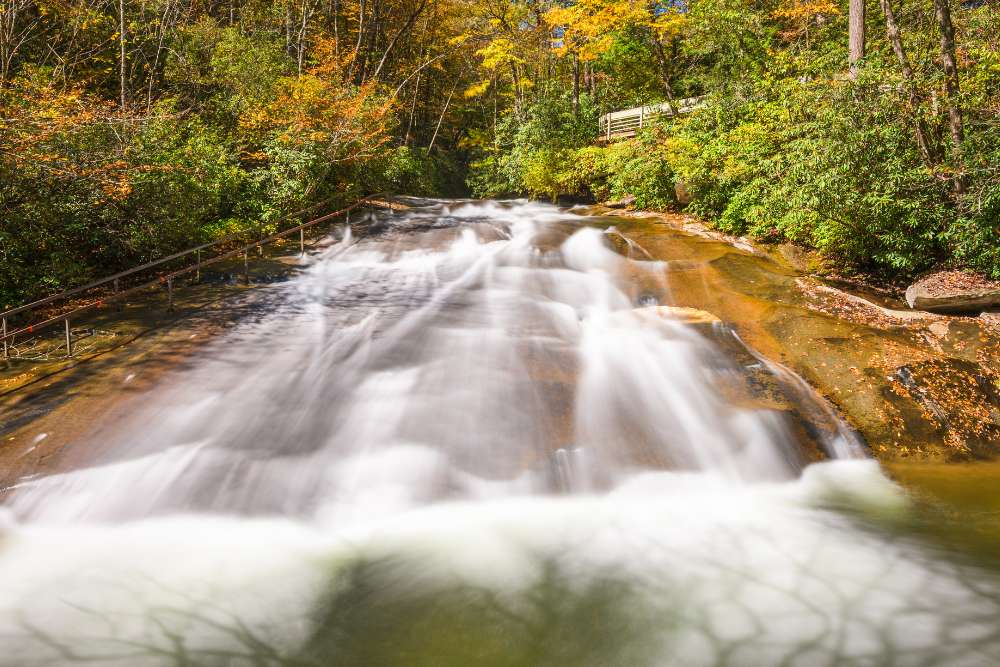
Sliding Rock is North Carolina’s most popular natural water slide.
It’s 60 feet long, and tourists may slide down the waterfall, which dumps 11,000 gallons of water into the tidal pool every minute.
The pool is around 6-7 feet deep. From Memorial Day weekend through Labor Day, the slide is a Forest Service recreation facility with lifeguards and employees on duty.
Because they are so close together, you may combine a visit to Sliding Rock with a visit to Looking Glass Falls (see below).
Because the water is chilly, it is best to visit on a hot summer day.
A leisurely inner tube cruise down the Green River is a great way to beat the heat.
This is a lot of fun for both adults and children (must be 5 years old or 42 inches tall). Green River Cove Tubing provides a 3-mile (about 2-1/2 hours) and a 6-mile (approximately 4-1/2 hours) tubing tour.
Tubes, transportation to the launch location, client recuperation at the end of the trip, and parking are all provided by Green River Cove Tubing.
We took the 3-mile journey downriver from the launch location and had a great time! It was one of the most enjoyable activities we’ve ever done, and our nephews enjoyed it as well.
The youngest was nine years old, and he was tethered to his mother, making it a little more difficult to traverse some of the rocks.
There were just enough rapids to keep it exciting without being too dangerous. I can’t express how much fun we had for only $9.00 per person.
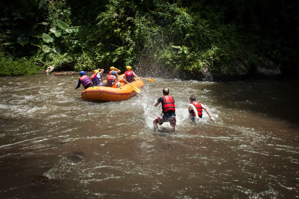
3. White Water Rafting on the French Broad River
This is the nearest whitewater rafting to Lake Lure, North Carolina, and it features class I–IV rapids.
From a 5-mile trip (3–4 hours, class I–III rapids) to a 9-mile excursion (3–6 hours, class I–IV rapids), French Broad River Rafting provides a range of rafting adventures.
Depending on the water flow, the time range might change.
Because the French Broad River is a broad, free-flowing river, the severity of the rapids is determined by recent rainfall.
As a result, heavy rain makes for a faster and more interesting journey. My nephews loved it and gave it a thumbs up.
4. Horseback Riding at Cedar Creek Stables
Cedar Creek Stables is situated on the shores of Lake Lure.
On their 350 acres of picturesque trails, they offer a range of equestrian trail rides ranging from 1 to 2 hours, as well as pony rides for their younger riders.
Their outstanding guides and well-behaved horses have received rave reviews.
This is an excellent choice for a novice or starting rider, as well as smaller children.
5. Riding Stables on the Riverside
Riding is available for all ages at Riverside Riding Stables.
Pony rides for children ages 2 to 6, a 1-hour trail ride for children ages 14 and up, and a 2-hour trail ride for children ages 14 and up are all available.
The 2-hour trip is for the more daring riders who desire to swim through the river with their horse.
They also have three-day, two-night overnight pack excursions available.
6. Take a Zipline Adventure Tour of the Canopy
In and around Lake Lure, there are numerous zipline choices where you may soar through the lush, green woods of the Blue Ridge Foothills and explore the lovely Hickory Nut Gorge and neighboring locations.
One of the only zipline programs open to both children and adults is Boulder line Adventure Programs.
Richard and Tammy specialize in creating custom programs for schools, camps, civic groups, and other organizations.
They’re extremely hands-on educators, which makes for a fantastic family outing.
You’ll discover a climbing tower, a gigantic V-swing, and even Night Flight excursions all throughout the immaculate and gorgeous grounds, in addition to zip line trips that generally take approximately 2 hours.
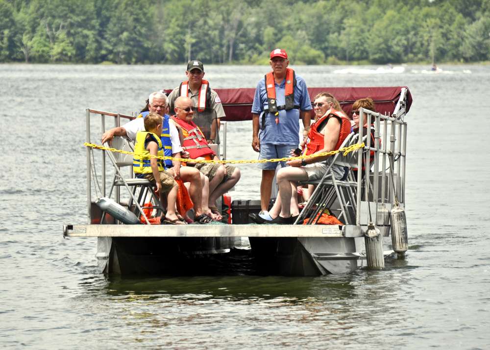
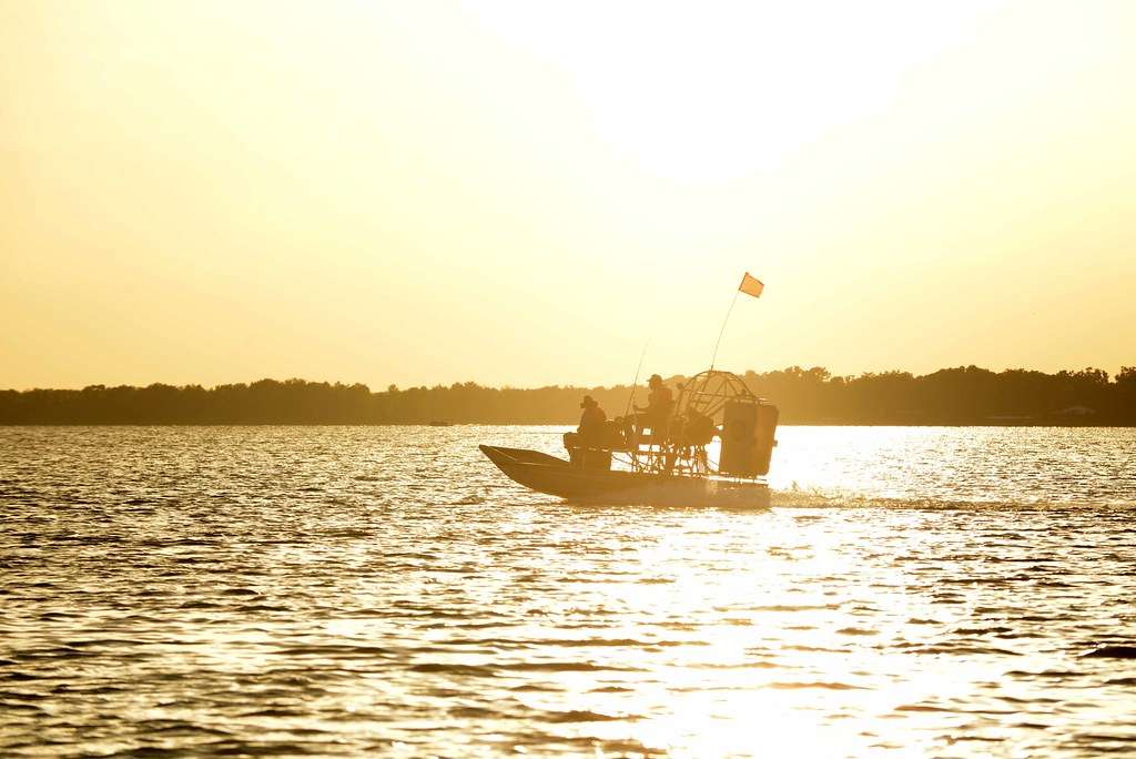
7. Rent a boat, go tubing, or wakeboarding
Lake Lure Adventure Company provides a variety of water activities, including boat rentals, water skiing or wakeboarding trips, guided fishing trips, wakeboarding, and paddleboarding.
If you wish to tube or water ski, this is a wonderful alternative because tubing and water skiing are not permitted on rental boats.
Moonshine Mountain is the place to go in Western North Carolina for a seasonal snow tubing fun.
You’ll find 500-foot tubing lines, a gift store, a fire pit area, and Ugly Pit BBQ’s rib-sticking barbeque. This is a lot of fun in the snow!
8. Play FootGolf at the Lake Lure Golf Club
FootGolf was introduced to the course in June 2015 to provide non-golfers another way to enjoy the gorgeous grounds.
Using golf regulations, players kick a soccer ball through a nine-hole course to 21″ holes.
The United States FootGolf Association built and certified the Lake Lure FootGolf course, which was the first certified FootGolf course in North Carolina.
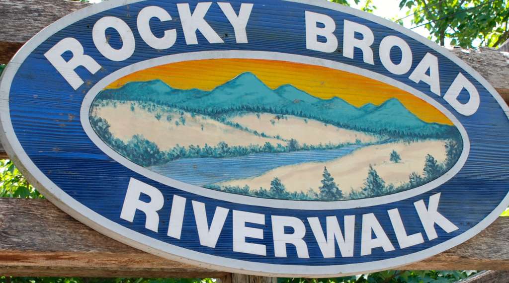
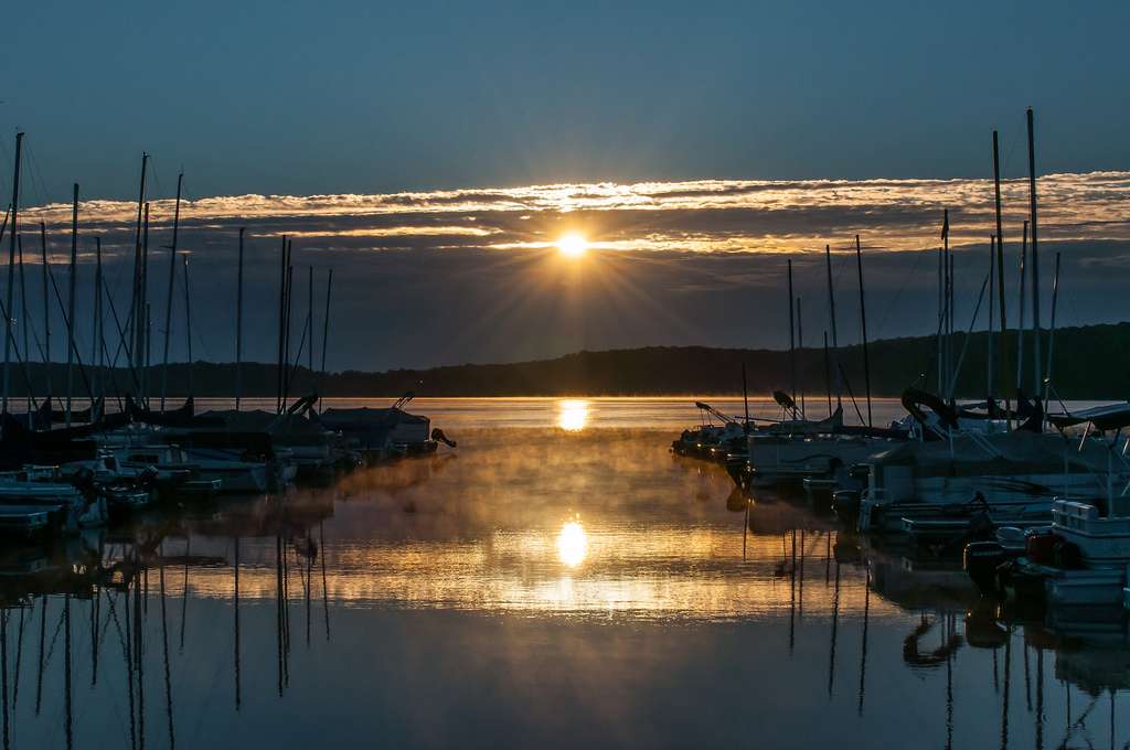
9. Riverwalk on Rocky Broad
In the heart of Chimney Rock Village, enjoy free entertainment along the Rocky Broad River.
Along a 1/8 mile route, a natural boardwalk with stone arches, huge boulders, and rushing water meanders.
Pack a picnic, wade in the river, skip stones, and enjoy life’s simple pleasures while shopping and dining along the riverside.
My nephews love it, and that’s where we got the huge image at the start of this piece.
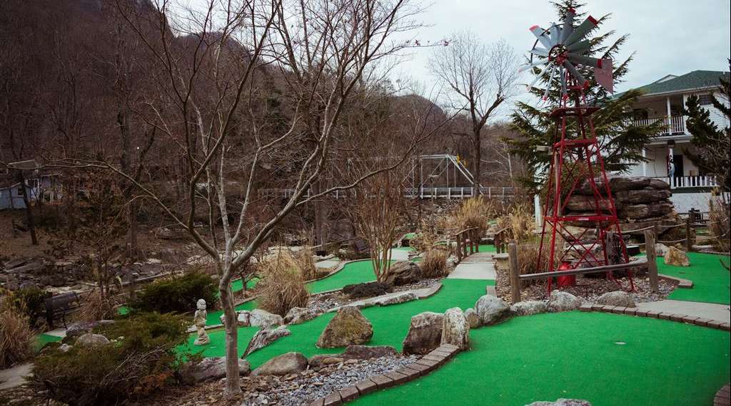
10. Broad River Inn’s Mini-Golf Adventure
Play putt-putt golf on a lovely, naturally landscaped miniature golf course in Chimney Rock Village, which is located along the Rocky Broad River.
Play 18 holes of tough mini golf while listening to the sounds of the river and admiring the sights of the Blue Ridge Mountains. This is a family-friendly experience.
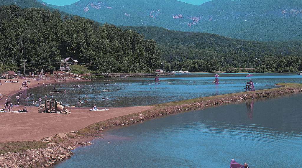
11. Beach and Water Park at Lake Lure
Spending the day at the beach is one of the best activities to do with kids in Lake Lure. On lovely Lake Lure, enjoy the simple pleasures of a day at the beach.
Soak in the sun, relax in the cold waters of the lake, and take in the breathtaking splendor of the Blue Ridge Mountains.
The Water Park, which includes soaking activities, a water slide, and a water wars area, makes for wet fun in the heat for the kids.
The cost of entrance to the beach includes access to the water park.
12. Lake Lure Walking Tour at Morse Park
Morse Park, located between the beach and The Flowering Bridge, offers beautiful views of the surrounding mountains, Lake Lure, and the local flora and animals.
There is a lovely path around the park, as well as picnic tables, tennis courts, and a children’s playground.
13. Flowering Bridge at Lake Lure
The Lake Lure Flowering Bridge is home to over 700 different plant varieties as well as seasonal ornamental gardens.
The gardens, which are tended by local volunteers, are free and available to the public all year.
In the winter, the bridge’s colorful lighting welcomes visitors to take a stroll across it.
Along the way, a cell phone audio tour gives information.
The audio tour’s Sensory Trail section details individual plants that you may smell, touch, and even taste.
14. Visit the Donald Ross Nature Trail Park
While there are many hiking opportunities in the Lake Lure area, Dittmer-Watts Nature Trail Park is ideal for smaller children.
It’s surrounded by nature, and the paths are well-kept and range in difficulty from simple to moderate.
There are two open fields where children may run and play, as well as a number of picnic shelters scattered throughout the park.
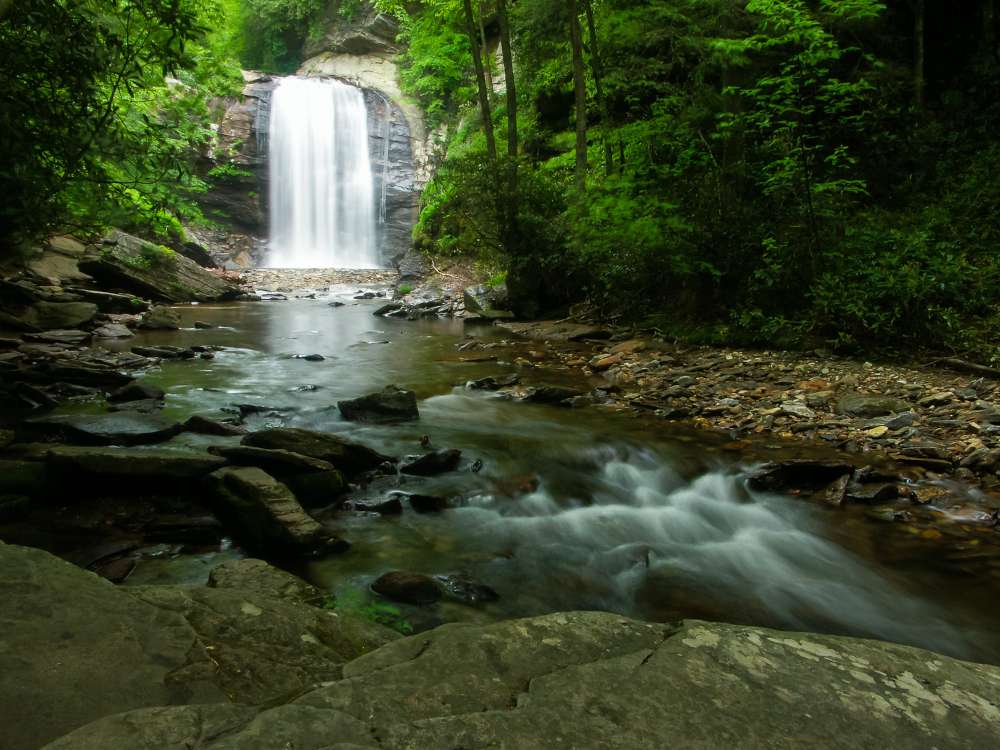
15. Looking Glass Falls
Looking Glass Falls is one of North Carolina’s most well-known waterfalls, located in the Pisgah Forest.
It can be seen from the roadway, which is ideal for young children or anyone who have trouble walking, and the top is wheelchair accessible, with a magnificent view of the 60-foot waterfall.
If you’re feeling brave, go for a short stroll down below for a closer look and perhaps a swim, although there are no lifeguards on duty.
Because they are so close together, you may combine a visit to Looking Glass Falls with a visit to Sliding Rock (above).
16. Pearson Falls waterfall experience
This waterfall is on the list because it is another easily accessible, magnificent waterfall; but, because it is a nature sanctuary, there is an admission charge and several limitations.
Pearson’s Falls is located between Tryon and Saluda in Western North Carolina, along Highway 176. 268 acres of natural woodland, granite, and spring-fed streams make up this animal and bird sanctuary.
The 90-foot waterfall is reached through a short, scenic 1/4-mile path. This is a fantastic picnic spot.
To preserve the beauty, a number of limitations have been imposed: Swimming, climbing, smoking, dogs, fishing, and weapons are all prohibited activities.
For further information, go to the website.
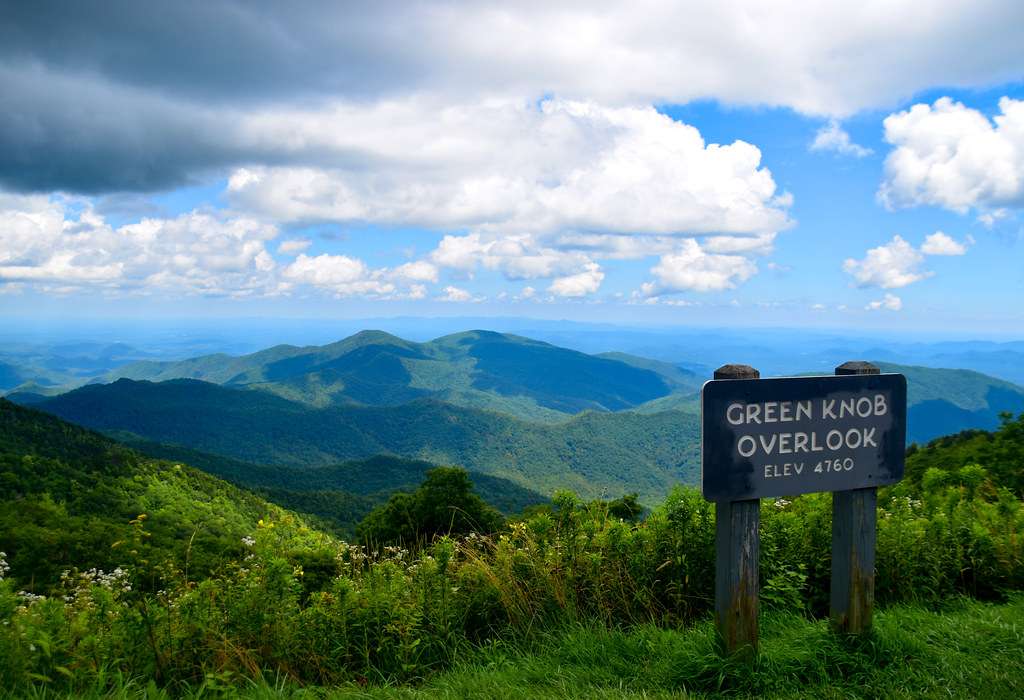
17. Endless Miles of Scenic Beauty on the Blue Ridge Parkway
Beautiful vistas of the Blue Ridge Mountains may be seen from the Blue Ridge Parkway in Asheville, North Carolina. Along the Blue Ridge Parkway, there are several magnificent viewpoints and places of interest.
All of them are well-marked, have dedicated parking places, and some even provide short walks and hiking paths to enjoy.
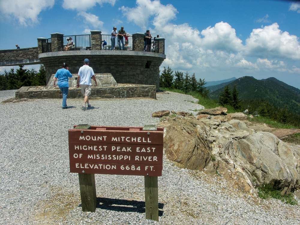
18. Visit to the highest peak of Mississippi at Mount Mitchell State Park
Mount Mitchell State Park is located in Burnsville, North Carolina, right off the Blue Ridge Parkway.
Mount Mitchell’s top, at 6,684 feet above sea level, is the highest point east of the Mississippi.
The stone observation platform is reached by a short walk that begins at the summit parking area.
On a clear day, tourists may see for up as 85 miles and take in breathtaking views of the surrounding mountains and Pisgah National Forest.
A concession stand, gift shop, tiny history museum, and longer treks are all accessible.
Because of the inconsistency of the weather at that elevation, it’s crucial to check the website for road and park closures.
We like to go around the park and then eat lunch at The Mount Mitchell View Restaurant.
19. Arboretum of North Carolina
The North Carolina Arboretum is located at Milepost 393, adjacent to the magnificent Blue Ridge Parkway, and is placed in one of America’s most stunning natural settings, consisting of 434 acres of public gardens within the Pisgah National Forest.
There are over 10 miles of hiking and bicycling trails, guided walks, geocaching (10 total), indoor and outdoor displays, festivals, plant shows, and more at the Arboretum.
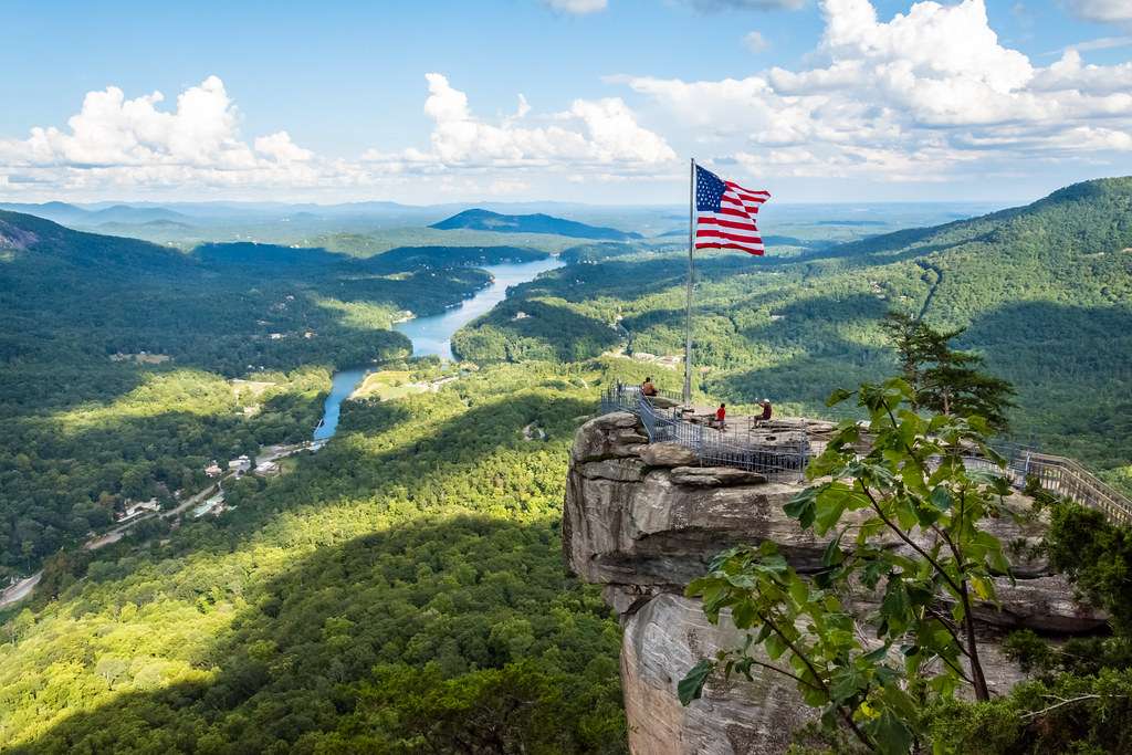
20. Visit Chimney Rock State Park
Chimney Rock State Park offers a variety of activities, including stunning panoramic views of Lake Lure, a 404-foot waterfall, and filming locations for The Last of the Mohicans.
There are five distinct paths to choose from, each with a different level of difficulty.
Those seeking an exercise can go for the Outcroppings Trail, which is an alternative to utilizing the Chimney’s 26-story elevator.
The Great Woodland Adventure, which comprises of a.6-mile route and 12 Woodland Creature Discovery Stations, will appeal to youngsters throughout the year.
21. Visit the Toy Train Museum
Toy trains from the early 1900s to the present will be on display.
Several tracks with operational trains are put up, and visitors may operate the trains themselves!
Our youngest engineers have their own railway area, complete with push trains, engineer costumes, and coloring pages!
A $5 contribution per person is required for admission.
Children under the age of two are free.
The Pancreatic Cancer Action Network receives 100% of your gift.
Final words
As you can see, you will be able to discover numerous activities to engage with while you are spending time at the Lake Lure. Plan your trip accordingly, and you will end up going home with the best experiences.
You can find both freshwater lakes as well as saltwater lakes in North America. It is even possible to classify them as man-made lakes and natural lakes. The surface area and volume of these lakes are being used to determine their size. You can find a variety of marine species in these lakes as well. Let’s explore the biggest lakes that you can possibly discover in North America as of now.
1. Lake Superior – it is the world’s largest by surface area
Lake Superior is the world’s biggest freshwater lake, as its name suggests (by surface area).
And every turn of its 2,700-mile magnificent shoreline offers a lifetime’s worth of vistas.
Pictured Rocks National Lakeshore has 200-foot sandstone cliffs, beaches, and waterfalls that cascade into the lake; the Apostle Islands’ Sea caves; and the solitary roughness of Isle Royale, which is home to wolves and moose.
To get to your desired location, you can trek, drive, kayak, or take a boat. As the intrepid surfers of North Shore will attest, this lake is so large that it may feel like an ocean.
Going fishing on Lake Superior allows you to take a deep breath of fresh air, gaze in wonder at breathtaking lake vistas, and quietly study the various creatures that come to drink at the lake’s shore.
You’ll have front-row access to all the lake has to offer from the comfort of your boat, and while you troll for your next catch, the calm and peace of Lake Superior will keep you amused.
When you do get a bite, the three most popular species in Lake Superior are coho salmon, king salmon, and lake trout.
Otherwise, expect to see carp, herring, whitefish, muskellunge, pike, melt, bass, walleye, or perch dangling off the hook, ready to eat.
Hiking the numerous miles of trails available to visitors is one of the finest ways for outdoor lovers to explore Lake Superior.
The Superior Hiking Trail in northern Minnesota is 205 miles long, winding through the area’s vast wilderness and following the rocky shoreline of Lake Superior.
There are several paths in American and Canadian national parks, ranging in difficulty from simple to difficult, that provide vistas of beautifulwoodland, waterfalls, and even indigenous pictographs.
Our United States National Parks bordering the lake — Isle Royale National Park (Michigan), Pictured Rocks National Lakeshore (Michigan), Apostle Islands National Lakeshore (Wisconsin), and Grand Portage National Monument (Minnesota) — are likely to have the path you’re looking for.
Learn about the Lake Superior Largest Lake in the USA
2. Lake Huron – one of the five Great Lakes of North America
Lake Huron is one out of five Great Lakes that you can discover in North America. It contains 850 cubic miles of water.
On the other hand, it contain a massive shoreline of 3,825 miles.
The lake covers a total area of 3,825 miles as well. This lake was inhibited by native Americans back in the day.
Many types of flora and wildlife may be found on Lake Huron, and nature enthusiasts will appreciate exploring the lake’s many parks and preserves.
Mackinac Island State Park is a unique experience: the island park is like stepping back in time, with no automobiles allowed but lots of horse-drawn carriages, bicycles, and pedestrians.
Before venturing off to examine nature’s own wonders of unusual rock formations, stunning blue waters, and lots of birding for the keen observer, stop at a lovely small hamlet, a historic fort, and a lively harbor.
If you’re thirsty for information, explore the historic villages of Cedarville and Hessel, which serve as a jumping off point for a trip out onto the lake and a tour of the 36 surrounding islands.
The islands are only accessible by boat, and there are several guided trips as well as kayak and canoe rentals available in the area.
The islands were initially inhabited by the Ojibwa Native Americans thousands of years ago and were given the name Les Cheneaux by the French.
They formed tiny towns in the 1800s after the entrance of the French and European settlement, and were home to Scandinavian, Irish, and Italian immigrants.
The Historical Museum and the Maritime Museum are both located on the Cedarville waterfront and are packed with Lake Huron history, European influences, and a variety of other nuggets that are sure to pique the interest of history buffs.
Lake Huron is recognized for fantastic fishing and is considered one of the top walleye fishing sites in the United States, in addition to its historical experiences.
If you’re serious about catching walleye for dinner, go to Saginaw Bay (Michigan) during the summer.
Anglers may expect to catch salmon, bass, musky, and trout throughout the year, in addition to the abundant concentrations of walleye that have helped make Lake Huron renowned.
3. Lake Michigan – the second-largest of the Great Lakes by volume
With a shoreline covering four states, Lake Michigan is the third biggest of the Great Lakes and the only one that does not touch Canada.
On Lake Michigan, Chicago is a big metropolis. However, the majority of visitors come to play on the lake’s section on Michigan’s Lower Peninsula.
Top attractions include the Sleeping Bear Dunes National Lakeshore, which features 450-foot-high sand dunes.
The United States and Canada have the world’s biggest network of linked freshwater lakes in terms of total area and second-largest in terms of total value.
This set of five lakes, known as the Great Lakes of North America, comprises 21% of the world’s freshwater by surface area.
All of the lakes, which are located on or near the Canadian border, are connected to the Atlantic Ocean by the St. Lawrence River.
Lake Michigan is the pride and pleasure of Wisconsin, Illinois, Indiana, and Michigan since it is the only Great Lake entirely inside the United States’ borders.
The lake spans 22,400 square miles, making it the world’s biggest freshwater lake (by surface area) enclosed within a single nation.
Lake Michigan is roughly 307 miles long and 118 miles broad, with 1,640 miles of shoreline.
More than 80 lighthouses may be found along the coast and on major islands. Lake Michigan, on the other hand, is more than a lake of superlatives; it is a freshwater paradise that is home to 12 million people and attracts thousands of visitors each year.
Lake Michigan and Lake Huron are linked by the five-mile-wide Straits of Mackinac, which are both 577 feet above sea level. In terms of hydrology, this unites the two lakes, which some refer to as Lake Michigan-Huron.
Lake Michigan and Lake Huron are treated separately by LakeLubbers; however, the combined surface area and volume are considered “points of interest” by Lakelubbers.
Lake Erie is the fourth biggest of North America’s five Great Lakes. It separates Canada (Ontario) from the United States (Michigan, Ohio, Pennsylvania, and New York) to the north, west, south, and east.
The lake’s primary axis stretches 241 miles (388 kilometers) from west-southwest to east-northeast, with a maximum width of 57 miles.
The lake’s drainage basin covers a total area of 30,140 square miles (78,062 square kilometers), excluding the surface area of 9,910 square miles.
The Detroit (carrying Lake Huron’s outflow), Huron, and Raisin rivers of Michigan; the Maumee, Portage, Sandusky, Cuyahoga, and Grand rivers of Ohio; the Cattaraugus Creek of New York; and the Grand River of Ontario are the lake’s main tributaries.
The Niagara River empties the lake at its eastern end, while the western end includes all of the islands, the largest of which is Pelee Island, Ontario.
Erie has the shortest mean depth (62 feet) among the Great Lakes, and its deepest point is 210 feet, with a mean surface height of 570 feet (170 meters) above sea level.
The lake has a relatively short water-retention duration of 2.6 years due to its tiny size and shallow nature.
Storms regularly produce short-term variations in lake level, which can reach several feet at the lake’s ends. It’s a vital part of the St. Lawrence Seaway.
The New York State Barge Canal has a terminus on the Niagara River in Tonawanda, New York, and one of its branches joins Lake Erie at Buffalo.
Learn about the largest clear clean water lake in New York
5. Lake Ontario – is one of the five Great Lakes of North America
Lake Ontario is the smallest and most easterly of North America’s Great Lakes.
On the north, it is bordered by Ontario (Canada), while on the south, it is bordered by New York (U.S.).
The lake is approximately oval in shape, with a main axis that runs almost east to west and a maximum width of 53 miles (85 km).
The lake’s drainage basin covers a total area of 24,720 square miles (64,025 square kilometers), excluding the lake’s surface area of 7,340 square miles (19,011 square km).
The Genesee, Oswego, and Black rivers from the south, as well as the Trent River from the north, are all major feeders of the lake. The lake’s eastern end, which is 30 miles wide, is spanned by a chain of five islands before it empties into the St. Lawrence River at Kingston, Ontario.
Lake Ontario has a mean depth of 283 feet (86 meters) and is 802 feet deep at its deepest point.
It has a mean surface height of 243 feet (74 meters) above sea level (244 m).
A broad surface current runs eastward at 8 miles per day, with the greatest current near the south coast.
The navigational Welland Canal and the natural Niagara River serve as links to Lake Erie to the southwest.
Lake Ontario is connected to Lake Huron’s Georgian Bay through the Trent Canal in Trenton, Ont., and the New York State Barge Canal in Oswego, N.Y.
The Rideau Canal stretches from Kingston to Ottawa in northeastern Ontario.
Learn about the largest natural lake in California
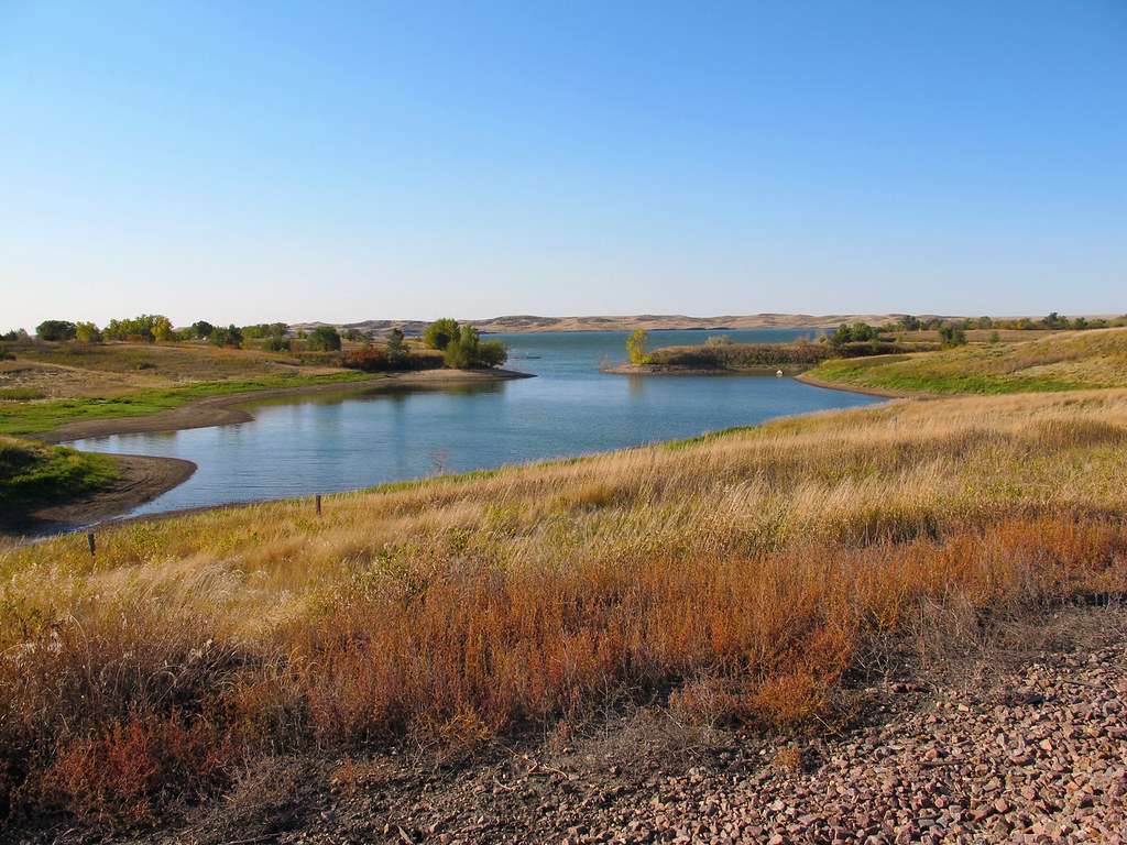
6. Lake of the Woods – the sixth largest freshwater lake located in the United States
The picturesque Lake of the Woods is located on the Canadian–US border, where the provinces of Ontario and Manitoba, as well as the state of Minnesota, meet.
It is 70 miles (110 kilometers) long and up to 60 miles (95 kilometers) broad, with a surface area of 1,727 square miles (4,472 square km).
The lake’s shoreline is believed to be 25,000 miles (40,000 kilometers) long, with over 14,000 islands.
The Rainy River feeds the lake from the southeast, and it flows northwestward into Lake Winnipeg through the Winnipeg River.
It is at a height of 1,060 feet (323 meters) above sea level and drains a total area of 27,170 square miles (70,370 square km).
Jacques de Noyon, a French explorer, first visited the lake in 1688, and it eventually became an important fur-trading route between the Great Lakes and western Canada.
It is presently home to four provincial parks in Ontario.
The main lakefront city is Kenora, which is located near the northern end of the lake.
The Northwest Angle (Lake of the Woods County) is the northernmost point of the conterminous United States, separated from the rest of Minnesota by a portion of the lake.
7. Lake Champlain – is a natural freshwater lake in North America
Lake Champlain is a lake in Quebec province, Canada, that stretches 107 miles (172 km) southward from Missisquoi Bay and the Richelieu River, where it empties into the St.
Lawrence River, to South Bay, near Whitehall, New York. For the most part, it serves as a border between Vermont and New York, and it sits in a large valley between the Adirondack and Green mountains.
The lake is 14 miles (23 kilometers) wide at its widest point, with a total area of 435 square miles (1,127 square kilometers) of water surface and 55 square miles (142 square kilometers) of islands (including Grand Isle and Isle La Motte, Vermont, and Valcour Island, New York).
Lake George runs along to Champlain on its narrow southern coast and drains into it via a small canal at Ticonderoga, New York.
The increased lake levels that occurred during deglaciation resulted in many terraced highland features on both sides of the lake.
Learn about the largest body of water wholly contained within Illinois
8. Lake St. Clair – is a freshwater lake
Lake Saint Clair is a large shallow basin that forms part of the border between Michigan and Ontario in Canada.
It links the St. Clair River and Lake Huron (north) with the Detroit River and Lake Erie (south) with a surface size of 467 square miles (1,210 square kilometers) (south).
It measures 26 miles (42 kilometers) long and 24 miles (39 kilometers) broad from north to south, with a mean surface altitude of 573 feet (175 m).
The lake’s drainage basin is 7,420 square miles in size (19,220 square km).
The huge delta of the St. Clair River, with seven channels, runs along its northern shoreline. The St. Lawrence Seaway has a minimum channel depth of 27 feet (8 meters) for shipping, and the lake region is a popular summer vacation destination.
The western coast is home to some of Detroit’s richest suburbs, although there are no major ports on the lake.
10. Rainy Lake – is a freshwater lake with a surface area of 360 square miles
Rainy Lake is a small lake that runs along to the Canadian-American border, between Minnesota and the Rainy River region of northeastern Ontario, Canada.
It covers 360 square miles (932 square kilometers), is roughly 50 miles (80 kilometers) long, with 35 miles (56 kilometers) of international border, and an average width of 5 miles (8 kilometers) with a maximum of 27 miles (43 km).
It has uneven and highly indented coastlines, as well as around 500 islands.
The Rainy River, which is 85 miles (137 kilometers) long, drains into Lake of the Woods.
Voyageurs National Park, Minnesota’s only national park, is accessible from Rainy Lake.
Begin your journey east of International Falls at the Rainy Lake Visitor Center. Visitors who want to launch their own boat, canoe, or kayak can do so for free at the Center.
During the summer, the Center also provides guided boat trips looking for wildlife and stopping at Little American Island to learn about the 1890s Rainy Lake gold rush.
Visitors can reach Voyageurs National Park by driving on plowed lake roads or using snowmobiles, cross-country skis, or snowshoes when the waters of Rainy Lake ice.
Nature enthusiasts can pitch their tents on designated park islands once they arrive at Voyageurs National Park. Loons, eagles, otters, deer, black bear, and moose may be seen by keen observers when camping.
On the Canadian side of the lake, Sandpoint Island Provincial Park is located.
The Park, which is only accessible by boat, provides beach bathing, hiking, and animal watching, but no tourist amenities.
11. Mille Lacs Lake – is a large but shallow lake in the U.S
Mille Lacs Lake commands a commanding presence in Minnesota’s Central Region. Lake Mille Lacs is Minnesota’s second biggest inland lake, covering 132,000 acres.
The huge lake, which is rather shallow, is one of numerous glacial pothole lakes found 100 miles west of Duluth.
The Rum River, which drains into the Mississippi, is the only exit, fed by over 20 minor tributaries.
The Brainerd Lakes area was once known as the “Region of Thousand Lakes” (Pays de Mille Lacs) by early explorers.
The name persisted since it was the biggest lake in the group. According to archaeologists, the region surrounding the lake has indications of being the location of Minnesota’s first human habitation.
The Dakota and subsequently the Ojibwa were the native American populations in the area when the first European explorers arrived. In the mid-1700s, Father Hennepin paid a visit to the lake, and a tiny state park is named for him on the southern coast.
The Mille Lacs Band of Ojibwa now owns 61,000 acres of reservation property that stretches from the south coast to the east.
Power boating, water skiing, tubing, pontoon boating, jet skiing, canoeing, kayaking, and swimming are just a few of the water sports available in Mille Lacs Lake.
Sailing has grown in popularity, with regattas and sailboard events hosted on a regular basis. The huge lake is ideal for windsurfing, a relatively new activity in the area.
12. Leech Lake – It is used as a reservoir
Leech Lake is the third biggest lake wholly in Minnesota, the “Land of 10,000 Lakes,” with approximately 120,000 acres of water and 316 miles of shoreline.
Leech Lake is located in Cass County, Minnesota, and is surrounded by the Chippewa National Forest and the Leech Lake Indian Reservation for the most part.
Leech Lake is a recreational paradise as well as a nationally known game fish lake. Leech Lake has so much to offer that tourists will want to return again and again.
The Leech Lake basin is said to have been created thousands of years ago by a melting glacier.
The Leech Lake Dam was built along the Leech Lake River by the US Army Corps of Engineers in 1882.
In 1884, the Headwater Reservoir project was finished, raising the water level of Leech Lake by four to seven feet and connecting several additional natural lakes to form what is today Leech Lake.
The dam was rebuilt in the early 1900s, with the timber abutments being replaced with concrete.
Visitors at Leech Lake Dam may see the original tender’s home, which was also erected in the early 1900s.
The tender’s home was moved to a new location immediately south of the recreation area in 2002.
Leech Lake is a wonderful location to rest and unwind.
On Leech Lake, there are several lakefront vacation rentals as well as real estate for sale for individuals who want to purchase their own getaway or permanent property.
On Leech Lake, camping is available at the Leech Lake Campground, which is run by the US Army Corps of Engineers.
13. Moosehead Lake – is a deep, Coldwater Lake
The biggest lake in Maine is Moosehead Lake, which is situated in the Longfellow Mountains in the Maine Highlands Region.
It is 1,023 feet above sea level, has over 300 miles of shoreline, is 120 square miles (approximately 75,000 acres) in size, and extends 40 miles long by 10 miles broad.
Sugar Island is the largest of the more than 80 islands that make up Moosehead Lake.
Moosehead Lake is a natural lake that created about 12,000 years ago as Maine’s glaciers receded. Moosehead Lake is the source of the 150-mile Kennebec River.
The storage dams at the lake’s East and West Outlets are owned by FPL Energy’s Kennebec Water Power Company.
Hydroelectric power, flood control, recreation, and drinking water are all provided by Moosehead Lake.
The West Outlet Dam has been in operation since the 1830s.
Year-round activities for the whole family are available at Moosehead Lake.
Boating, kayaking, canoeing, white river rafting, swimming, bird viewing, camping, fishing, golf, hiking, moose watching, and horseback riding fill the long summer days.
Big Moose Mountain, on the lake’s western bank, offers downhill and glade skiing in the winter.
14. Lake St. Francis – is a lake which borders 3 states
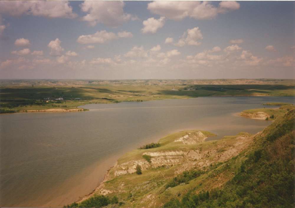
Lake Francis Case is located along the Missouri River in south-central South Dakota and is one of the most popular leisure destinations in the Great Plains.
Lake Francis Case is one of four reservoirs built along the Missouri River in South Dakota: Lewis and Clark Lake, Lake Sharpe, and Lake Oahe are the other three.
Lake Francis Case stretches 107 miles from Pickstown to Big Bend Dam in Fort Thompson, South Dakota, and offers a variety of recreational opportunities including fishing, camping, swimming, boating, bird watching, water skiing, and hunting.
Lake Francis Case was formed by damming the Missouri River, as authorized by the Flood Control Act of 1944.
The Omaha District Corps of Engineers began construction on Fort Randall Dam in 1946 and finished it in 1956.
Flood control, hydroelectric generation, navigation support, irrigation, municipal water supply, fish and wildlife management, and recreation were all goals of the dam.
Fort Randall Dam is named after a former military garrison. The fort’s chapel is the lone relic of the ancient Fort Randall.
Colonel Daniel W. Randall, a deputy paymaster of the Army, was named after the fort.
15. Lake Winnibigoshish – Its name comes from the Ojibwe language
Lake Winnibigoshish is one of Minnesota’s most famous bodies of water.
The lake’s massive expanse, which spans more than 58,500 acres, extends into Minnesota’s Northwest and Northeast tourism districts.
Lake Winnie, as it is known, is a well-known vacation spot throughout the Midwest.
Since at least the late 1600s, Lake Winnibigoshish has been known to exist. In historical literature, the lake was also known as Lake Winnepeg, Winnipec, and Winnepeek, and its name is derived from the same origins as the famous Lake Winnebago.
The name translates ignobly into “miserable, terrible unclean water” in Ojibway.
This appears to be a frequent name given to small, muddy-bottomed lakes by area Native Americans.
Storms may rapidly turn the shallow waters into a filthy froth, according to early explorers.
For millennia, a Native American community on the lake’s south side has lived by casting their nets over the shallow Mississippi River outflow as their primary source of food.
All of it altered when white explorers arrived.
16. Oneida Lake – is the largest lake entirely within New York state
Oneida Lake is the biggest lake wholly inside the state of New York, covering more than 51,000 acres.
Oneida Lake is roughly 21 miles long and more than five miles broad at its widest point and was named after the Oneida Tribe of the Iroquois Nation who inhabited in the region.
The lake is part of the Erie Canal system, which gives access to the Great Lakes from the Atlantic Ocean.
The Thousand Islands, Finger Lakes, and Central-Leatherstocking tourist regions in New York state are all bordered by the lake.
Sylvan Beach, a resort village on the eastern coast with a variety of vacation homes, is the most popular tourist destination on Oneida Lake.
Swimming, boating, sailing, fishing, and enjoying the various restaurants, souvenir shops, and the historic Erie Canal are just a few of the exciting summer activities available at Sylvan Beach.
Sylvan Beach Amusement Park, which opened in the 1800s and includes well-maintained rides do not present in today’s amusement parks, is a must-see for amusement park fans.
The excitement doesn’t stop when the sun sets at Sylvan Beach, as the town boasts of being a thriving hub of nightlife and entertainment on Oneida Lake.
17. Lake Winnipesaukee – The lake contains 264 islands
The lake is enormous and driving around it is a 63-mile journey.
365 islands dot Lake Winnipesaukee’s surface, with 274 of them really inhabitable, as if to demonstrate its vastness.
It is preferable to observe the lake by boat due to its enormous vastness and the convoluted nature of driving around circle.
You may bring your own boat or hire one when you arrive, but you’ll be in for a treat if you go out into the Winnipesaukee seas.
With a lake the size of Lake Winnipesaukee, tourists might expect to discover public beaches where they may cool down on a hot summer day.
The lake’s 240-mile shoreline is littered with public beaches. The most popular swimming spot, Weirs Beach, is located on the western shoreline and features a boardwalk, playground, and picnic area.
Ellacoya State Campground, which is located on the western shoreline, has a long sandy beach and an RV park.
Melvin Village Wharf, Leavitt Park, 19 Mile Bay Beach, and 20 Mile Bay Beach are all located on the northern end of Lake Winnie.
Near Wolfeboro, on the eastern shoreline, are Brewster Beach and Carry Beach. A bathing facility at Alton Bay, on the lake’s southeastern end, rounds off the list.
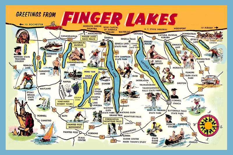
18. Seneca Lake – is the largest of the glacial Finger Lakes
Seneca Lake, one of the famed Finger Lakes in western New York, is the state’s biggest lake fully contained inside its borders.
Seneca Lake is a huge 43,343-acre lake with a length of 38 miles, including Watkins Glen on the south bank and Geneva on the north.
The lake is the second deepest in New York State, with a maximum depth of 618 feet, and was used for submarine testing.
Local legend claims that a submarine is submerged in the lake’s chilly depths.
Seneca Lake offers a breathtaking view of azure waters, even bluer skies, and spectacular sunsets.
It was called after the Seneca Indian Nation, which was one of the six Iroquois Confederacy tribes that lived in the region.
The name Seneca comes from the Iroquois term Assiniki, which meaning “stone place” or “stony spot.”
Seneca Lake features the steepest, rockiest shoreline of all the Finger Lakes, making this a fitting name.
In reality, the lake is famed for its painted rocks, which depict an American flag, a teepee, and many Native Americans and are found on its southern shoreline.
The paintings are supposed to memorialize the Seneca tribe’s heroic escape to Fort Niagara in the 1700s from General John Sullivan.
Although historians believe that the escape took place, it is unclear if the paintings were created by the Seneca tribe or by the boat trip business years later to promote tourism at the lake’s more remote southern end.
19. Cayuga Lake – is the longest of central New York’s glacial Finger Lakes
Cayuga Lake is the second biggest Finger Lake in terms of surface area and volume, located in western New York.
With a length of 38.2 miles, an average width of 1.7 miles, a surface area of 42,956 acres, and a maximum depth of 435 feet, this Finger Lake will provide you with plenty of space to explore.
The lake’s natural beauty is preserved because to the parks and protected areas surrounding it.
At the south end of the lake sits the Allan H. Treman State Marine Park, which is home to Cornell University.
The Park has one of New York’s largest inland marinas, including a marina, boat launch, pump out station, fishing pier, picnic tables, and playing fields for tourists.
The Montezuma National Wildlife Refuge, run by the US Fish and Wildlife Service, is located near the north end of the lake.
What began as a migratory bird refuge has evolved into a 7,200-acre preserve with swamps, ponds, and water channels that serve as both a temporary and permanent home for migrating birds as well as terrestrial animals and marine species in the region.
All four seasons offer plenty of opportunities to see animals in their natural environment.
Cayuga Lake State Park, the area’s third park, attracts visitors with its beaches, moderate slopes to the lake, campgrounds, cottages, and numerous fishing spots.
Frontenac Island, one of only two islands in the Finger Lakes system, is proudly housed on Cayuga Lake.
If you enjoy fishing, the lake and its solitary island provide the ideal setting for your hobby.
The northern pike population on Frontenac Island is well-known, as are the excellent fishing conditions.
Lake trout, rainbow trout, brown trout, smallmouth bass, largemouth bass, perch, bullhead, bluegill, crappie, rock bass, and more species may be found in Cayuga Lake.
The lake’s main attraction, though, is its world-renowned trout fishing. So, grab your poles and bait box and travel up to Cayuga for a day of fishing in the midst of lovely, clear lakes.
20. Lake Vermilion – is a shallow freshwater lake in northeastern Minnesota
The bright Lake Vermilion in northern Minnesota, dubbed “Lake of the Sunset Glow” by its ancient Ojibwe people, is a wonderfully perfect retreat.
With a surface size of 40,557 acres and an average depth of 76 feet, this beautiful body of water is massive.
The location is flanked by the untamed Superior National Forest, which lies smack dab in the midst of Minnesota’s wildness.
It’s no surprise that the natural freshwater lake is one of the most popular in the state, with its breathtaking sunsets, incredible fishing possibilities, and diverse range of water sports.
The long history of Lake Vermilion dates back to 7000 B.C., when people first began to flourish there. In order to better trade furs with the Sioux Indians, French traders built a port at Lake Vermilionin 1670.
The Chippewa tribe continues to live in the neighboring areas today.
A gold rush in 1865 proved futile just a few years later, although it did bring a large number of residents to the lake.
Soon after, iron ore reserves were found, giving a practical alternative to the newly developed gold mining sector.
Nearby communities like Soudan and the City of Tower grew and prospered. Finally, in 1890, a dam was built to sustain the growing settlements.
Final words
Now you are aware about the biggest lakes that are present in North America. It is up to you to visit any of these lakes and experience the natural beauty offered by them. These lakes offer something for everyone with their size. Hence, you can keep this list in mind and plan your upcoming vacation.
There are hundreds and thousands of lakes in the United States. Out of them, you can find some massive lakes as well. Let’s take a quick look at the biggest lakes that you can discover in the United States as of now. Any person who has an obsession with large lakes can think about visiting any of these lakes in the country.
1. Lake Superior – Largest Lake in the USA
Lake Superior, the largest, deepest, coldest, cleanest, least developed, and most pristine of the Great Lakes, is the world’s largest freshwater lake by surface area, spanning state and nation boundaries.
This 31,820 square mile behemoth is the fourth largest in terms of volume, with 2,900 cubic miles (9,799,680,000 acre feet), or 400,000 gallons of water for every person on the planet.
Today, these vast swaths of land are home to national parks, water sports, and a plethora of other activities.
Lake Superior is known by various names, including Gichigami, which means “large water” in the Ojibwe language.
The huge lake is alluded to as “Gitche Gumee” in both Henry Wadsworth Longfellow’s The Song of Hiawatha and Gordon Lightfoot’s The Wreck of the Edmund Fitzgerald.
Finally, in the 17th century, French explorers named the lake le lac superieur, or Upper Lake, from whence the English “Lake Superior” was derived.
Despite not being an inland sea, the lake is massive: its surface area of 20,288,000 acres is greater than South Carolina, and it spans for more than 350 miles in length and 160 miles in breadth.
Waves on Lake Superior may often surpass 30 feet, and the lake’s lowest point — 1,333 feet deep — is also the lowest point on the North American continent, at 733 feet below sea level.
The lake has 2,726 miles of shoreline to explore, and if the lake’s drain lock were to be uncorked, it would flood both North and South America, submerging the continents under a foot of water.
Lake Superior is a very magnificent piece of water. Gates on the Saint Marys River at Sault Sainte Marie manage water levels on Lake Superior for hydroelectric power generation.
The International Joint Commission manages the lake’s water levels through the Board of Controls.
Following the retreat of the previous Ice Age’s frozen glaciers, the Plano first settled on the lake 10,000 years ago.
The Shield Archaic peoples arrived around 5,000 years later, leaving traces of their bows, arrows, boats, and fishing equipment all throughout the region.
The Ojibwe and Cree, the lake’s most recent indigenous occupants, are thought to be direct descendants of these early people.
By the 1700s, however, European influence surrounding Lake Superior had grown significantly, owing in part to the burgeoning fur trade.
What were once ancient mining and maritime communities are now modern shipping ports with a new industry: tourism.
2. Lake Huron – one of the five Great Lakes of North America
Lake Huron is the second biggest of the five Great Lakes in terms of surface area, with a surface area of 23,010 square miles and a 3,825-mile shoreline.
The huge lake, which has 850 cubic miles of fresh water inside its basin, is the third biggest of the Great Lakes in terms of water volume.
With such vast lengths of water, as well as the lake’s rocky rip-rapped shoreline and sandy beaches, Lake Huron has become a popular destination for tourists, part-time residents, and full-time inhabitants who enjoy the sun and water fun that this Great Lake offers.
Lake Huron was inhabited by Native Americans, especially the Algonquin and Iroquois, who had been competitors for generations before European arrival.
After failing to find any of the other Great Lakes, French explorers dubbed it La Mer Douce, or the Freshwater Sea, when they landed on the lake’s shores in 1612.
On early maps, the lake was frequently referred to as Lac des Hurons, or Lake of the Huron Indians.
By 1615, the French had formed bonds with the lake’s Native American tribes and had acquired some of their habits and trades, accumulating money via wood, fishing, mining, and fur production.
Naturally, these businesses and the quest of money led to the French and Indian War, which ravaged the region for seven years.
Today, the lake has recovered from past abuses and is teeming with wildlife, fish, and a plethora of other natural wonders.
The beaches of Lake Huron appear to go on forever, which might be daunting at first.
When planning your visit, think about what you want to do, where you want to travel, and how you want to organize your time.
If you’re coming from the Michigan side of the lake, start your journey on Michigan’s Sunrise Coastal Highway, a 10-mile stretch of road that runs along the lake’s coastline and has asphalt-paved pathways for bicyclists, skaters, and walkers.
The trails begin in Rogers City and weave their way to the lake’s edge, where they meet Lake Huron’s soothing, lapping waters and smooth sandy beach.
The street route eventually leads to Hoeft State Park, a lovely 300-acre wildlife refuge with its own trails that connect to the Huron Sunrise Trail, providing an excellent transition for further hiking and bicycling.
3. Lake Michigan – second-largest of the Great Lakes by volume
Lake Michigan is the pride and pleasure of Wisconsin, Illinois, Indiana, and Michigan since it is the only Great Lake entirely inside the United States’ borders.
The lake spans 22,400 square miles, making it the world’s biggest freshwater lake (by surface area) enclosed within a single nation.
Lake Michigan is roughly 307 miles long and 118 miles broad, with 1,640 miles of shoreline.
More than 80 lighthouses may be found along the coast and on major islands.
Lake Michigan, on the other hand, is more than a lake of superlatives; it is a freshwater paradise that is home to 12 million people and attracts thousands of visitors each year.
Lake Michigan and Lake Huron are linked by the five-mile-wide Straits of Mackinac, which are both 577 feet above sea level.
In terms of hydrology, this unites the two lakes, which some refer to as Lake Michigan-Huron.
Lake Michigan and Lake Huron are treated separately by LakeLubbers; however, the combined surface area and volume are considered “points of interest” by Lakelubbers.
Many towns and cities line the beaches of Lake Michigan, but you’re probably best familiar with Chicago (Illinois), East Chicago (Indiana), and Milwaukee (Wisconsin) (Wisconsin).
Many Lake Michigan beaches may be found in these towns and their surrounding areas, especially those in Michigan and Northern Indiana are known for their remarkable beauty.
In fact, the region is sometimes referred to as the United States’ “Third Coast,” as it rivals certain beaches on the Atlantic and Pacific Oceans.
These Midwestern beaches are an oasis in the heart of the country, with smooth, white sand that is said to “sing” as you walk through it.
Learn about the largest natural lake in California
4. Lake Erie– the eleventh-largest lake globally
Lake Erie, one of North America’s Great Lakes, crosses the states of Ohio, Pennsylvania, New York, Michigan, and Ontario in Canada.
The lake was named after a Native American tribe that lived along its shores before being exterminated by the Iroquois League for assisting their adversary, the Hurons.
Lake Erie is the fourth biggest in surface area, the most southern-reaching, the shallowest, and the smallest in volume among the Great Lakes.
But don’t be fooled: Lake Erie has a surface size of 9,940 square miles (6,261,500 acres), spans 241 miles in length and 57 miles in width, has 871 miles of shoreline, and reaches a maximum depth of 210 feet.
Lake Erie is the only Great Lake that freezes over on a regular basis, owing to its modest average depth of 62 feet.
Lake Erie is known as the “Walleye Capital of the World” and is widely regarded as having some of the greatest walleye fishing in the world.
The lake’s modest depths provide a perfect environment for walleye and make it great for ice fishing.
But don’t worry if walleye isn’t your thing. Yellow perch, steelhead, salmon, and smallmouth bass are also popular in the lake.
Whether you go out on your own to fish the depths or hire one of the numerous fishing charters in the region, you’ll have an interesting and gratifying fishing experience.
Lake Erie is enormous, and with it comes a plethora of recreational opportunities.
Swimming in the calm blue waters, boating, hiking, birdwatching, seeing the natural flora and wildlife, playing on a sandy beach, water skiing, dining lakeside, and a variety of other activities are all available.
Depending on your own preferences, the possibilities are nearly limitless.
Learn about the largest clear clean water lake in New York
5. Lake Ontario – is one of the five Great Lakes of North America.
The deep, bright, and pristine waters of Lake Ontario, one of the world’s five Great Lakes, meander over state and nation lines, captivating Americans, Canadians, and visiting visitors.
The smallest of the Huge Lakes, with a whopping 4,700,000 acres (7,340 square miles), Lake Ontario is the ideal monument to the enormous size and importance of these great, glacial lakes.
Lake Ontario, which has been home to many people throughout the years, is now surrounded by Toronto, Hamilton, and Rochester, and serves as an aquatic playground for those who visit its shores.
Lake Ontario gets its name from a Huron term that means “big lake,” as opposed to the Iroquois’ “Skanadario.
” The colossus has been called “Lac Ontario or des Iroquois,” “Ondiara,” and “Lac Frontenac” in addition to its Native American titles.
The vast reservoir’s rich history, which began with the Iroquois and Huron nations, is reflected in the wide range of names it has received.
The first contemporary European to see the lake was Etienne Brule, who came in 1615, however relics show that he was beaten by the Norse, who arrived much earlier.
Lake Ontario is remembered today for its contributions to modern history, including the French and Indian War, the American Revolution, and the War of 1812.
The Niagara River carries around 80% of the water that flows into Lake Ontario from its western neighbor, Lake Erie.
The rest comes from streams of Lake Ontario and precipitation.
Over 90% of Lake Ontario’s water goes to the St. Lawrence River, with the remainder evaporating and dropping as massive winter snowfalls in northern New York State.
Issues pertaining to any of the Great Lakes system’s lakes are of considerable importance both here and as far upstream as Lake Superior, as the last of the downstream Great Lakes.
The water level of Lake Ontario is controlled by a dam at Kingston, Ontario, for hydroelectric power generation.
The International Joint Commission manages the lake’s water levels through the Board of Controls.
6. Great Salt Lake – the largest saltwater lake in the Western Hemisphere
The Great Salt Lake, sometimes known as “America’s Dead Sea,” covers roughly 1,700 square miles of Utah land.
It is the second biggest lake entirely enclosed inside the United States (by surface area); only Lake Michigan is bigger.
The Great Salt Lake has the longest lake coastline in the United States, spanning roughly 10,000 miles.
The biggest relic of the ancient Lake Bonneville, Great Salt Lake has a salinity significantly greater (saltier) than ocean water.
Despite its moniker, the lake is home to a diverse range of vegetation, wildlife, and water life, as well as a large number of tourists each year.
The Great Salt Lake’s water levels fluctuate depending on rainfall and evaporation rates, reaching a peak of 45 feet in 1987 and a low of 24 feet in 1963.
The number of islands dotting the lake varies depending on the water level. According to the Utah Geological Survey, there are 11 islands in the lake, with seven in the south and four in the north.
The Gunnison Island State Wildlife Management Area encompasses the whole island.
Because the island is an important rookery for the American White Pelican, public access is banned.
Antelope Island State Park is located on the biggest of the islands and is accessible through a causeway.
Antelope Island is home to pronghorn antelope, bighorn sheep, American bison, and waterfowl.
Learn about the largest body of water wholly contained within Illinois
7. Lake of the Woods – the sixth largest freshwater lake located in the United States
Lake of the Woods is a massive body of water that stretches from Minnesota into the Canadian provinces of Ontario and Manitoba, measuring over 68 miles long and 59 miles broad with 25,000 miles of coastline – the world’s longest lake shoreline.
The western half of the lake is largely open water, but the eastern half is studded with about 14,500 islands where bears, moose, bald eagles, and other species may be found.
With its mind-boggling number of islands, the shoreline of Lake of the Woods stretches over 65,000 kilometers.
Minnesota owns about a third of the lake’s 950,400 acres.
Because of landmark treaties going back to 1783 when Great Britain acknowledged American freedom, part of Minnesota’s land portion of Lake of the Woods, known as the Northwest Angle, is isolated from the rest of the United States.
The Northwest Angle is the contiguous United States’ northernmost territory.
It is accessible by boat from Minnesota or by crossing Canadian territory. Following treaties defining the US-Canada border, the Northwest Angle remained in Minnesota.
Because the Lake of the Woods is so big, it’s important to choose a section and adhere to it.
However, everyone wins here, as the lake provides a variety of outdoor activities for nature lovers.
Start your vacation with a stroll along one of the lake’s nature trails; the coastline is lined with winding routes, difficult terrain, and manicured trails that will give you with amazing views and stunning panoramas.
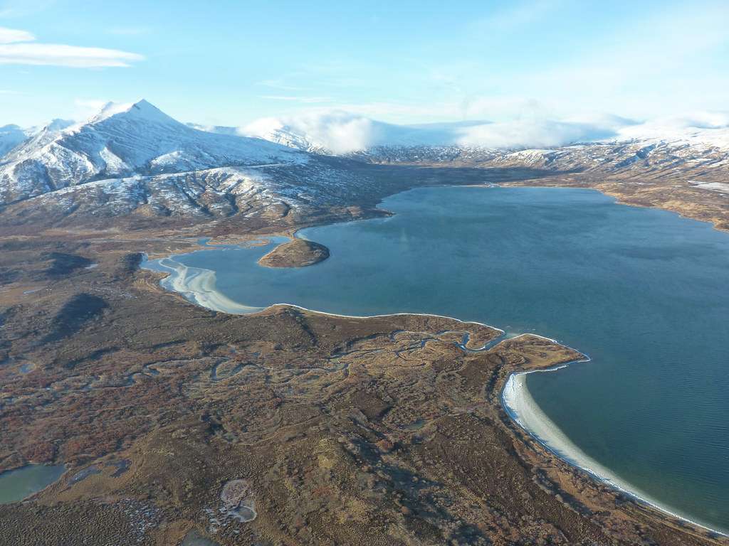
Iliamna Lake, commonly known as Lake Iliamna, is Alaska’s biggest lake and the world’s second-largest freshwater lake entirely enclosed inside the United States (after Lake Michigan).
This glacial lake in southwest Alaska is known as an inland sea, with a length of 80 miles, a width of 25 miles, and a surface area of roughly 640,000 acres.
Iliamna Lake is bordered to the north by Lake Clark National Park and Preserve, to the south by Katmai National Park and Preserve, and to the east by Cook Inlet (Gulf of Alaska).
Porcupine, Flat, Triangle, and Seal Islands are among the deserted islands that dot the lake’s surface.
The Tanaina Indians named the lake Iliamna because they believed it was home to a huge blackfish that could bite holes in boats.
Other monsters rumored to reside in Iliamna Lake, known as Lilies, resemble 30-foot-long gigantic fish.
When pilots began seeing monsters from the air in the 1940s, Iliamna’s creatures became more well-known.
In contrast to these mythological animals, the lake is known for its resident colony of freshwater seals, which is one of only two freshwater seal colonies in the world.
Learn about the lake Michigan the second-largest of the Great Lakes by volume
9. Lake Oahe – the fourth-largest reservoir in the US
The name Lake Oahe comes from an Oahe Indian Mission and means “base” or “place to stand on.”
Lake Oahe is the nation’s biggest manmade reservoir in surface acreage and fourth in volume, stretching 231 miles from Pierre, South Dakota, to Bismarck, North Dakota, and boasting a 2,250-mile coastline.
Lake Oahe, which is located north of Pierre on South Dakota Highway 1804, is steeped in Native American heritage.
Lake Oahe, which was originally built for hydroelectric power generation, flood management, downstream navigation, irrigation, public water supply, and fish and wildlife preservation, is today a haven for outdoor enthusiasts with 50 recreational sites.
Lake Oahe was formed by damming the Missouri River as part of a US Army Corps of Engineers operation.
Construction began in 1948, as authorized by the Flood Control Act of 1944. President John F. Kennedy dedicated the dam and lake on August 17, 1962.
Lake Oahe is the world’s 14th biggest man-made reservoir by volume, with a storage capacity of 23.5 million acre-feet.
The length of Oahe Dam is 9,300 feet, with a maximum height of 245 feet.
The 2,250 kilometers of shoreline of Lake Oahe are mainly undeveloped, except from recreational areas.
Visitors will see a mixed grass prairie with trees growing down to the water’s edge.
On the western side of the lake, the Cheyenne River Sioux Reservation in South Dakota, and the Standing Rock Sioux Reservation in both North and South Dakota are both major Native American reservations.
If you want to go big game hunting, the Cheyenne River Sioux Reservation offers three wildlife areas designated aside for elk and buffalo.
Every year, the Cheyenne River Sioux Game, Fish, and Parks Department offers hunts.
10. Lake Okeechobee – eighth largest natural freshwater lake in the US
Lake Okeechobee is a lake with numerous names, having approximately 451,000 blue, aquatic acres.
It is the largest lake in Florida in terms of surface area. It is also the fourth-largest lake entirely enclosed inside the United States of America.
Lake Okeechobee, commonly known as Florida’s Inland Sea, Lake O, and The Big Lake, has an average depth of only 9 feet.
The name Lake Okeechobee comes from the Hitchiti words for “water” (oki) and “large” (chubi), therefore the lake’s original name was “Big Water”.
The Okeechobe Waterway, which stretches from the Gulf of Mexico to the Atlantic Ocean, includes Lake Okeechobee.
From Fort Myers to Lake Okeechobee, the waterway follows the Caloosahatchee River, then continues east via the St. Lucie Canal to Stuart.
Navigation, year-round recreational amenities, potable water, agricultural irrigation, and flood control are all benefits of the Okeechobee Waterway.
The Central and Southern Florida Flood Control Project includes the Waterway.
11. Lake Pontchartrain – the lake that is oval in shape
Lake Pontchartrain isn’t officially a lake. It’s known as an estuary in scientific circles.
That’s just a fancy way of saying it’s a coastal body of water with an open connection to the sea or is connected to the sea in some way.
Although Lake Pontchartrain is surrounded by land, it is connected to the Gulf of Mexico by a marsh on one side.
It is classified as a Salt Lake, however salinity levels along the lake’s northern boundary hardly register where rivers pour into the lake.
As one moves towards the Gulf, the salt levels rise; the maximum values are roughly half those of sea water in the Gulf.
There are daily tide variations because it is connected to the Gulf.
Lake Mauripas, a neighboring freshwater lake, is connected to the west shore of Lake Pontchartrain through Pass Manchac.
In addition, the Mississippi River enters the Lake through New Orleans’ Industrial Canal.
Aside from the Ole Miss, the lake receives fresh water from five additional rivers and two bayous. Tchefuncte, Tickfaw, Amite, Bogue Falaya, and Tangipahoa are the rivers, and Chinchuba and Lacombe are the bayous.
After Hurricane Betsey wreaked havoc on New Orleans, the Flood Control Act of 1965 allowed the building of the Lake Pontchartrain and Vicinity Hurricane Protection Project.
The levees that we see today were developed and built by the Army Corps of Engineers.
The parishes of Jefferson, St. Charles, Orleans, and St. Bernard are responsible for the maintenance and flood management of their respective parts of the barrier system.
The heights of the levees were determined by the geography of the surrounding region when they were erected. The height ranged from 9.3 to 13.5 feet.
12. Lake Sakakawea – the second largest lake in the United States by area
The second-largest reservoir by surface acreage in the United States (and third-largest in volume), Lake Sakakawea spans 178 miles from Garrison Dam northwest to Williston, North Dakota, and has a surface area of roughly 382,000 acres.
Lake Sakakawea is two to three miles wide on average and six miles wide at its widest point.
The gently rolling prairie and 1,300 miles of shoreline, located 75 miles north of Bismarck, North Dakota, offer a diverse range of activities for visitors.
Camping, boating, fishing, sailing, nature watching, hunting, and ice fishing are examples of recreational activities.
The Missouri River was dammed to create Lake Sakakawea. Garrison Dam was built in 1947 after being authorized by the Flood Control Act of 1944, also known as the Pick-Sloan Plan.
Garrison Dam, which extends 2,050 feet wide at the base and tapers out to 60 feet wide at the top, was completed in 1954 and is presently the world’s sixth biggest earthen dam.
Garrison Dam provides a variety of public benefits, including fish and wildlife preservation, flood control, navigation, irrigation, and recreation, in addition to hydropower generation.
Visitors can take a tour of the power plant, which also features exhibits on the construction and operation of the Garrison Dam.
13. Lake Champlain – natural freshwater lake in North America
Lake Champlain is a natural freshwater lake that straddles the states of New York and Vermont in the United States and Quebec in Canada.
It is 96 feet above sea level. President Bill Clinton recognized Lake Champlain as a Great Lake in 1998, and it reaches a maximum depth of 400 feet, encompasses 435 square miles, stretches more than 100 miles in length, and has a maximum width of 12 miles at its widest point.
Lake Champlain has a total area of 271,000 acres and a coastline length of 587 miles. A total of 71 islands dot the lake, including a full Vermont county.
Burlington, Vermont’s Lake Champlain Region is a year-round living and tourist destination that offers a wide range of recreational and residential opportunities.
Burlington and the surrounding Champlain Lake valley were named “One of Four Outstanding Get-Away Locations in the Northeast” by USA Weekday Magazine, “Number One Place for Families that Love Outdoor Sports” by Outdoor Explorer Magazine, “Sixth Best Family Friendly Place in the Nation” by Reader’s Digest, and “Number One Child Friendly City in America” by Zero Population Growth.
14. Becharof Lake – eighth on list of largest lakes of the United States by volume
On the Alaskan Peninsula, Becharof Lake is the second* biggest lake in the state.
The lake is 35 miles long and 15 miles broad, with depths of up to 600 feet, and spans an astonishing 290,000 acres.
Becharof Lake, located deep in the Alaskan tundra, provides an amazing environment for hunting, fishing, hiking, and animal observation.
Becharof Lake, located in the Becharof National Wildlife Refuge, provides a picturesque and spectacular setting for activities such as fishing, hunting, hiking, and seeing Alaska’s abundant wildlife.
From jagged cliffs along the coast to sandy beaches, gently sloped tundra, and volcanic Mount Peulik on Becharof Lake’s southern coastline, the wildlife reserve provides a diverse range of stunning landscapes.
Only a boat, aircraft, or a hard trek along an unmarked path can access the 1.2 million-acre wilderness.
Before venturing into the wilderness, most guests take a commercial airplane from Anchorage to neighboring King Salmon Airport.
Hunting for bear, caribou, and moose, as well as fishing, hiking, and camping, are all popular activities at the refuge.
The refuge’s beautiful scenery and diverse fauna make it an excellent spot for wilderness observation and photography.
Congress has declared about 500,000 acres of the refuge as the Becharof Wilderness, ensuring that this region will be protected for future generations of nature enthusiasts to enjoy.
15. Lake St. Clair – It is part of the Great Lakes system
Heart-shaped The Great Lakes system’s smallest body of water is Lake Saint Clair.
The 275,200-acre Lake Saint Clair is ideally positioned in Detroit, Michigan and Windsor, Ontario, between Lake Huron to the north and Lake Erie to the south.
The St. Clair River, which flows into Lake Huron from the north, feeds the lake. The Thames River, Sydenham River, and Clinton River are among the other inflows.
The Detroit River transports water from Lake St. Clair to Lake Erie.
To the dismay and objections of many who have established a strong affinity with this essential component of the Great Lakes system, Lake St. Clair has been denied formal Great Lake designation.
Lake Saint Clair, formed by prehistoric glacial action, originally served as a hunting and trading ground for Paleo-Indian cultures.
The French-helmed Griffon, the first European vessel to sail in the Upper Lakes, found the lake in August of 1679.
There are two hypotheses on the origins of Lake Saint Clair’s name.
First, it’s said that the name comes from celebrating Saint Claire of Assisi’s feast day, with government authorities and mapmakers changing the spelling throughout time.
Second, many think the name was derived from General Arthur St. Clair, the first governor of the Northwest Territory.
Lake St. Clair has served as an essential waterway for generations of people throughout its colorful history, and it continues to do so today as a highly traveled portion of the Great Lakes Waterway and a vital link in the St. Lawrence Seaway.
16. Red Lake – largest natural freshwater lake located entirely within Minnesota
Upper Red Lake, located in Minnesota’s northwest region, has made a remarkable return and is once again becoming a popular vacation destination.
Upper Red Lake lies near Waskish and is located on the border of the Big Bog. When combined with Lower Red Lake, Upper Red Lake is Minnesota’s biggest freshwater lake.
Upper Red Lake, on its own, is Minnesota’s second-biggest lake, with Mil Lacs Lake being the largest.
The Narrows, a three-quarter-mile-wide canal that connects the two Red lakes, has 288,000 acres of great fishing grounds.
Upper Red Lake has a surface area of 120,000 acres, however only 48,000 acres are owned by the state of Minnesota and are open to the public.
The Red Lake Band of Chippewa Indians owns the remaining acres, as well as the entirety of Lower Red Lake, and its waters are off-limits to anybody not enrolled in their band.
In the early 1970s, the Red Lakes were well-known for their outstanding walleye fishing.
The walleye population, however, plummeted as a result of angling and gill net fishing, and walleye sport fishing was banned in 1999.
The restocking of walleye was a success in 2006, thanks to the efforts of both Native American and government authorities.
Anglers may now enjoy walleye fishing in Upper Red Lake thanks to new harvesting rules. Crappie and northern pike fishing are also popular at Upper Red Lake.
17. Selawik Lake – It is 31 miles (50 km) long
Selawik Lake is located in the northern region of Alaska, near the Arctic Circle. The lake is the third biggest in the state, with a surface area of 263,000 acres*.
The name Selawik Lake originates from an Inupiaq word that means “place of sheefish,” and the lake and its tributaries are particularly noted for this species of fish.
The lake is located around 7 kilometers from Selawik, Alaska.
Because of its secluded position, Selawik’s population of about 800 people continues to live much like their forefathers did, subsisting on the plentiful natural animals.
Selawik Lake is surrounded by a terrain that is both lovely and frightening.
Temperatures range from approximately -12 degrees Fahrenheit in the winter to around 58 degrees Fahrenheit in the summer.
Selawik is bright 24 hours a day for most of June and July due to its location on the Arctic Circle, but just an hour and a half of sunshine each day during the month of December.
Because of the difficult terrain surrounding Lake Selawik, residents still visit the region by boat during the summer and by dogsled during the winter.
Visitors generally arrive by plane, taking commercial flights from Anchorage to Kotzebue, a neighboring city.
Selawik has magnificent panoramas of unspoiled wilderness despite the severe environment.
Mountains, tundra, marshes, grassy meadows, and woodlands may all be found in the Selawik National Wildlife Refuge, a 2.15 million acre wilderness region that borders Selawik Lake.
18. Fort Peck Lake – reaching into portions of six counties
Fort Peck Lake is Montana’s largest lake and is located 20 miles southeast of Glasgow, Montana, on Montana Highway 24.
It is the country’s fifth-largest man-made reservoir by volume. Fort Peck Lake is one of six Missouri River lakes named after an ancient trading station.
Lake Sakakawea, Lake Oahe, Lake Sharpe, Lake Francis Case, and Lewis and Clark Lake are the other five lakes.
Despite the fact that droughts can cause water levels to drop, Fort Peck Lake always offers a wide range of recreational opportunities, including camping, boating, fishing, hunting, and animal watching.
Fort Peck Dam, the first dam erected in the upper Missouri River, began construction in 1933 as a project of the United States Army Corps of Engineers.
Franklin D. Roosevelt approved the Fort Peck project, which created over 10,000 employment during the Great Depression.
In 1938, a huge slip halted construction on the dam.
Fort Peck Dam is the biggest hydraulically filled dam in the United States, spanning 21,026 feet in length and 250 feet in height when completed in 1940.
Fort Peck Lake, which was originally built to generate hydroelectric power, is now utilized for fish and wildlife, irrigation, navigation, public water supply, flood damage reduction, enhanced water quality, and recreation.
19. Salton Sea – a shallow, landlocked, highly-saline body of water
The Salton Sea, sometimes known as Salton Lake, is a salty inland lake in southern California, near the Mexican border.
The construction of one of the world’s greatest inland seas was an accident: in 1905, flooding of the Colorado River allowed water to pour over the canal barriers for almost 18 months, resulting in the formation of one of the world’s largest inland seas.
The Colorado River water filled into the Salton Trough instead of irrigating the below-sea-level Imperial Valley.
The result is California’s biggest lake, with an average surface size of 360 square miles and 110 miles of shoreline.
The river flows were eventually redirected back into Imperial Valley irrigation and the Gulf of California in 1907.
There are no exits in the Salton Sea.
In the arid heat, the initial pure water from the Colorado River evaporated rapidly. Agricultural run-off from the New, Alamo, and Whitewater Rivers, transporting salt from the Colorado River, is the major source of inflow.
The Salton Sea is 25% saltier than the Pacific Ocean today.
20. Rainy Lake – a freshwater lake with a surface area of 360 square miles
Rainy Lake is a vast 221,000-acre lake that straddles the US-Canada border.
Rainy Lake is located in the Northeastern Region of Minnesota, near International Falls and Ranier, and is known as a water sports lover’s dream.
Rainy Lake is home to 75 percent of Canada’s part of this huge body of water, while the remaining 25 percent is in the United States.
With so much water, it’s no surprise that sports fans flock to this recreational paradise.
Boating, canoeing, kayaking, camping, swimming, hiking, and fishing are all popular activities on and near the lake.
Rainy Lake is a natural glacier-formed lake that has been dammed in both the United States and Canada.
The Kettle Falls Dam was completed in 1914, while the Fort Frances-International Falls Dam was built in 1909.
Boise Cascade Corporation in the United States and Abitibi Consolidated Inc. in Canada are in charge of each dam.
These are the largest lakes that you can discover in the United States as of now.
Visit any of these lakes, and you will be impressed with the size of it. Likewise, you can also discover numerous recreational activities to engage with.
Pennsylvania is a state where you can discover numerous natural landscapes. For example, you can see a perfect countryside in this state, which is represented by the Pocono mountains. On the other hand, you will also be able to discover a large number of stunning lakes within the state as well. You can discover a total of over 2,500 lakes within the state. These lakes are not just catering water to the people who live in the state. On top of that, we will also be able to see how people are provided the chance to use these lakes for recreational activities, such as fishing, swimming, boating, and kayaking. While keeping that in mind, let’s explore the best lakes in Pennsylvania.
1. Lake Erie – Largest Lake in Pennsylvania
Lake Eris is the largest lake in Pennsylvania as of size. The surface area of this lake is 9,910 square miles. This lake has a shoreline length of 799 miles.
The lake has water volume of 116 cubic miles. Moreover, the maximum depth of this lake is 210 feet. It is located at Lake Erie.
Lake Erie, one of North America’s Great Lakes, crosses the states of Ohio, Pennsylvania, New York, Michigan, and Ontario in Canada.
The lake was named after a Native American tribe that lived along its shores before being exterminated by the Iroquois League for assisting their adversary, the Hurons.
Lake Erie is the fourth biggest in surface area, the most southern-reaching, the shallowest, and the smallest in volume among the Great Lakes.
But don’t be fooled: Lake Erie has a surface size of 9,940 square miles, spans 241 miles in length and 57 miles in width, has 871 miles of shoreline, and reaches a maximum depth of 210 feet.
Lake Erie is the only Great Lake that freezes over on a regular basis, owing to its modest average depth of 62 feet.
Lake Erie is known as the “Walleye Capital of the World” and is widely regarded as having some of the greatest walleye fishing in the world.
The lake’s modest depths provide a perfect environment for walleye and make it great for ice fishing. But don’t worry if walleye isn’t your thing.
Yellow perch, steelhead, salmon, and smallmouth bass are also popular in the lake.
Whether you go out on your own to fish the depths or hire one of the numerous fishing charters in the region, you’ll have an interesting and gratifying fishing experience.
Lake Erie is enormous, and with it comes a plethora of recreational opportunities. Swimming in the calm blue waters, boating, hiking, birdwatching, seeing the natural flora and wildlife, playing on a sandy beach, water skiing, dining lakeside, and a variety of other activities are all available.
Depending on your own preferences, the possibilities are nearly limitless.
Learn about the Lake Superior Largest Lake in the USA
2. Pymatuning Lake – Second Largest Lake in Pennsylvania
Pymatuning Lake is the second largest lake that you can see in Pennsylvania. The surface area of this lake is 17,088 square miles.
This lake has a shoreline length of 170 miles. The lake has water volume of 17 cubic miles. Moreover, the maximum depth of this lake is 62 feet. It is located at Crawford County.
Pymatuning Lake is a lake of superlatives, located in northwest Pennsylvania and overflowing into northeastern Ohio.
It is the biggest lake in Pennsylvania, aside from Lake Erie, with an area of 17,088 acres, a length of 17 miles, and a width of 1.6 miles. Pymatuning Lake is also an important conservation area in North America, particularly for the Common Goldeneye, Canada Goose, and Hooded Merganser.
Pymatuning, like many other North American lakes, is a man-made reservoir. Its average depth is around 15 feet, with a maximum depth of about 35 feet, and it was completed in 1934.
It has a 70-mile-long coastline. The three campgrounds on the lake have the most campsites in one region in Pennsylvania.
Pymatuning State Park, where the lake is located, has more visitors each year than nearly any other park in the state, with over 4.5 million.
All of these adjectives add up to one thing: you and your family will have a fantastic time.
Pymatuning Lake is well-known for its year-round activities. Water sports possibilities abound beginning in the hot summer months.
Boating is one of the most popular activities, however tourists should be advised that all motorboats are subject to a 20 horsepower limit.
On the lake, there are three boat marinas: Jamestown Watercraft Concession, Espyville Marina Concession, and Linesville Marina Concessionaire. All three provide boat rentals, fishing equipment, and moorings.
Thousands of swimmers go to the five beaches and apparently limitless acres of cold, clear seas every year.
Take a power swim, a leisurely dip, or spend the afternoon drifting on a raft in the tranquil waters. Catch some rays in the sand while watching kids create sand castles all around you.
Whatever you do, you’ll feel calm and rejuvenated after spending time in the sea and on the beach.
Fishing is another favourite Pymatuning activity: The Fish and Boat Commission of Pennsylvania State Parks runs one of the world’s largest warm-water hatcheries.
Bring your pole (or rent one) and be ready to catch walleye, crappie, muskellunge, bluegill, perch, smallmouth bass, and largemouth bass in this well-stocked lake. Don’t let the seasons keep you from fishing: this Pennsylvania lake allows both summer and winter ice fishing.
3. Allegheny Reservoir – third largest lake in Pennsylvania
The third largest lake in Pennsylvania state is the Allegheny Reservoir. The surface area of this lake is 12,080 square miles.
This lake has a shoreline length of 120 miles. The lake has water volume of 17 cubic miles. Moreover, the maximum depth of this lake is 24 feet. It is located at the Warren County.
The Allegheny River, which is designated as a National Wild and Scenic River, is the major water supply for Allegheny Reservoir.
Kinzua Dam is located 198 miles northeast of Pittsburgh along the Allegheny River. The dam, which was completed in 1965 and is part of the US Army Corps of Engineers’ regional flood control operations, is operated by the US Army Corps of Engineers.
Allegheny Reservoir, also known as Kinzua Dam Lake, is currently a major recreational destination in the region.
The densely forested regions of Pennsylvania and New York, which were formerly home to the Seneca Nation, were clear cut by loggers in the 1800s. By 1900, attempts to restore the forest were well started.
In 1923, the Allegheny National Forest was established, and it was a huge success. Today, the forest that surrounds Pennsylvania’s part of the Allegheny Reservoir is a second-generation forest.
The Forest Service, which covers more than half a million acres, gives limitless possibilities to explore Lake Kinzua.
Along the Pennsylvania beaches of Allegheny Reservoir, several campsites have been established.
Camping options range from full-service sites for trailers and RVs to primitive spots only accessible by boat or hiking paths.
Kinzua Swimming Beach is 11 miles east of Warren, PA. Swimming places are also available in approved campsites.
Boating, waterskiing, hiking, mountain bike and ATV riding, climbing, geocaching, horseback riding, hunting, skiing, wildlife viewing, beautiful driving, and some of the greatest fishing in the northeast can all be found on Allegheny Reservoir and inside Allegheny National Forest.
Allegheny Reservoir’s deep, clear water has produced record-breaking catches of walleye and northern pike, with a maximum depth of 132 feet and an average depth of 48 feet.
Smallmouth bass, muskellunge, walleye, northern pike, yellow perch, channel catfish, and brown trout are among the other fish species present in Kinzua Lake.
The Allegheny National Forest has six more boat launches, including Kinzua-Wolf Run Marina, which is 11 miles east of Warren.
Learn about the largest natural lake in California
4. Raytown Lake – the largest man-made lake in Pennsylvania’s
There are numerous man-made lakes in the state of Pennsylvania.
The largest man-made lake out of them is the Raytown Lake. The surface area of this lake is 8,300 square miles.
This lake has a shoreline length of 79 miles. The lake has water volume of 85 cubic miles. Moreover, the maximum depth of this lake is 25 feet. It is located at Huntington County.
Raystown Lake is the largest lake fully inside Pennsylvania’s boundaries, with an area of 8,300 acres. The lake is located in Huntingdon County’s southern Allegheny Mountains.
It is 80 feet deep on average, with a maximum depth of 200 feet.
Raystown Lake was formed in 1913 when the US Army Corps of Engineers dammed the Raystown Branch Juniata River for flood control, hydroelectric generation, and recreational purposes.
Raystown Lake, dubbed “The Crown Jewel of Pennsylvania,” has 110 miles of mainly unspoiled coastline due to restrictions prohibiting residential and restricted commercial development.
Every year, nearly 2 million tourists flock to the lake’s unspoilt coastlines and natural splendor, each looking for a tranquil bit of lake enjoyment.
Learn about the largest body of water wholly contained within Illinois
5. Lake Wallenpaupack – prime recreation destination in northeast Pennsylvania’s
People tend to use the lakes located within Pennsylvania state for recreational purposes. Out of them, Lake Wallenpaupack is a prime recreation destination that you can see in the northeastern region of the state.
The surface area of this lake is 5,700 square miles. This lake has a shoreline length of 799 miles.
The lake has water volume of 116 cubic miles. Moreover, the maximum depth of this lake is 210 feet. It is located at Pike County.
Lake Wallenpaupack is a popular recreational area in northeast Pennsylvania’s Pocono Mountains, situated between the counties of Hawley, Pike, and Wayne.
The Pennsylvania Power and Light Company (PPL) built the lake in 1927 for hydroelectric power.
It spans 5,700 acres and has 52 miles of shoreline.
The greatest depth is 60 feet, with an average depth of 30 feet. Wallenpaupack is a Lenape Indian term that means “fast and sluggish water stream,” which is appropriate given that the lake was formed by Wallenpaupack Creek in Wilsonville.
Wilsonville vanished permanently beneath the waters of the lake after the dam was built.
During the summer months, the lake serves as a hub for water activity, with possibilities for boating, water skiing, swimming, and fishing. Smallmouth bass, largemouth bass, rock bass, muskellunge, rainbow trout, walleye, pickerel, and yellow trout are some of the lake species.
Anglers interested in mountain stream fishing can visit Wallenpaupack Creek or the Lackawaxen River, which are both stocked by the Pennsylvania Fish and Boat Commission.
You may launch your boat from any of the four public Recreation Areas on Lake Wallenpaupack if boating is your thing.
Vacationers may also hire boats from a number of marinas and resorts in the region. Daytime boating speeds are limited at 45 mph during busy summer weekends and holidays.
6. Shenango River Lake – provides flood protection for the Shenango River
The Shenango River Lake is offering flood protection for the Shenango River. The surface area of this lake is 3,560 square miles. This lake has a shoreline length of 35 miles.
The lake has water volume of 16 cubic miles. Moreover, the maximum depth of this lake is 17 feet. It is located at the Mercer County.
Shenango River Lake, which is primarily in northern Pennsylvania between Greenville and Sharon and spills into northeastern Ohio, protects the Shenango River Valley as well as the Beaver and upper Ohio Rivers from flooding.
During dry seasons, Shenango Reservoir releases water to increase the quality and quantity of downstream water for residential and industrial usage, leisure, and aquatic life.
The 11-mile-long Shenango River Lake offers a variety of outdoor leisure possibilities.
Picnicking, camping, boating, and admiring nature’s splendor are all popular activities at one of the many recreation or access locations.
Shenango River Lake is known for its bass, walleye, muskellunge, and a variety of panfish, all of which draw anglers. Thousands of fishermen go to the dam’s outflow region each spring to fish for trout stocked by the Pennsylvania Fish and Boat Commission.
With six boat launch ramps, boating is one of the most popular and diverse recreational activities at Shenango River Lake.
The majority of the lake is open to unrestricted horsepower boating and water skiing. Some parts of the lake are restricted to engines with a maximum horsepower of ten horsepower.
7. Lake Arthur – largest Lake with the clearest water
Lake Arthur is a lake in Pennsylvania, where you can find clear water. In fact, you can call it as the lake with clearest water.
The surface area of this lake is 3,225 square miles. This lake has a shoreline length of 29 miles. The lake has water volume of 17 cubic miles.
Moreover, the maximum depth of this lake is 12 feet. It is located at the Butler County.
Sailboats flit over Lake Arthur’s beautiful Pennsylvania waters like swarms of multicolored birds in the warm summer air.
This scenic lake, which is bordered by Moraine State Park and provides 3,225 acres of water to fish, boat, and explore, is located in Butler County.
Lake Arthur is an outdoor enthusiast’s dream, with its gently sloping hills, plentiful animals, and great fishing.
This was not always the case, though. The land that now makes up Moraine State Park was formerly covered with abandoned strip mines and oil and gas wells just forty years ago.
The area was intensively dug for oil and natural gas wells in the late 1800s, and deep coal mines and strip mines drastically altered the land’s contour.
To carry the materials to Pittsburgh, the Western Allegheny Railroad was created.
Parts of the railroad grade may still be seen in the Muddy Creek Finger of Lake Arthur and to the west of the dam, since the railroad stretched the whole length of the Muddy Creek Valley. It was decommissioned in 1939.
Learn about the largest clear clean water lake in New York
8. Youghiogheny River Lake – the heart of the Laurel Highlands
Youghiogheny River Lake is located within the heart of Laurel highlands. The surface area of this lake is 2,840 square miles. This lake has a shoreline length of 28 miles.
The lake has water volume of 24 cubic miles. Moreover, the maximum depth of this lake is 21 feet. It is located at the Somerset County.
Youghiogheny River Lake is located in the centre of the Laurel Highlands, crossing the Mason-Dixon Line between Pennsylvania and Maryland.
The United States Army Corps of Engineers encourages you to visit the project’s pristine waterways, mountains, and steep-sided valleys, which create an unrivalled environment for outdoor enjoyment.
Youghiogheny River Lake is a popular recreational destination that draws a large number of people each year.
Visitors may enjoy boating, hunting, camping, and a variety of other outdoor activities thanks to the excellent amenities available.
With its 16-mile length and half-mile-wide waterways, boaters consider Youghiogheny River Lake to be the greatest power boating and water-skiing lake in southwestern Pennsylvania.
There are several coves and backwater regions throughout the lake that give good fishing opportunities for anglers.
The lake is home to a diverse range of game and panfish, with walleye and smallmouth bass being particularly popular.
The Pennsylvania Fish and Boat Commission has been awarded a license to manage fish in the Pennsylvania part of the lake.
Learn about the lake Michigan the second-largest of the Great Lakes by volume
9. Lake Wilhelm – The shallowest lake in Pennsylvania
Lake Wilhelm is the shallowest lake you can see in Pennsylvania as of now. The surface area of this lake is 1,860 square miles. This lake has a shoreline length of 18 miles.
The lake has water volume of 36 cubic miles. Moreover, the maximum depth of this lake is 22 feet. It is located at the Mercer County.
The damming of Sandy Creek for flood control purposes resulted in the creation of Lake Wilhelm in 1971.
Lake Wilhelm is a small, shallow body of water with a maximum depth of around 24 feet near the dam. It covers a total of 2,800 acres.
Lake Wilhelm is located in Mercer County, about 15 miles west of Franklin, Pennsylvania, in Maurice K. Goddard State Park.
Natural beauty, animals, rivers, and public leisure facilities all abound in the park. Pennsylvania State Game Land also borders Lake Wilhelm.
Birdwatchers can see bald eagles and osprey fishing on Lake Wilhelm’s waters.
Bluebirds, purple martins, woodpeckers, woodcocks, nighthawks, snipes, and warblers may be found in the surrounding meadows, fields, and woodlands. In the spring and fall, migratory waterfowl such as loons, common teals, goldeneyes, mergansers, and buffleheads frequent Lake Wilhelm.
10. Lake Nockamixon – is a destination getaway for many travelers
Lake Nockamixon is a destination getaway that is available for most travelers within the state of Pennsylvania. The surface area of this lake is 1,450 square miles.
This lake has a shoreline length of 98 miles. The lake has water volume of 24 cubic miles. Moreover, the maximum depth of this lake is 17 feet. It is located at the Bucks County.
Lake Nockamixon is located in Bucks County, Pennsylvania, and is part of the 5,283-acre Nockamixon State Park.
The 1,450-acre reservoir is supplied by Tohicken Creek, Three Mile Run, and Hacycock Run, and is a popular weekend retreat for many visitors, especially those looking to get away from the hustle and bustle of Philadelphia.
The majority of park sections are accessible from sunrise to sunset, however certain fishing and boating areas are available all year.
A maximum of 20 horsepower is allowed on the lake.
The sparkling waters of the lake are studded with sailboats, motorboats, canoes, kayaks, and even inflatable watercraft filled with people enjoying the peace and quiet.
You may launch your own boat from one of four public boat launches, which are available 24 hours a day, or hire a canoe, rowboat, motorboat, sailboat, paddleboat, pontoon boat, or kayak from the boat rental concession.
It is important to know that swimming is not allowed in the lake. From Memorial Day to Labor Day, a half-acre swimming pool with two waterslides is open.
11. Lake Marburg – a spectacular recreational resource
Lake Marburg is a lake that offers an outstanding environment for the people to engage with their recreational activities.
The surface area of this lake is 1,275 square miles. This lake has a shoreline length of 75 miles. The lake has water volume of 14 cubic miles.
Moreover, the maximum depth of this lake is 19 feet. It is located at the York County.
Codorus State Park encompasses nearly the entirety of the lakeshore. The dam and water flows are owned and controlled by P.H. Glatfelter.
Boating and fisheries management are overseen by the Pennsylvania Fish and Boat Commission.
Anglers looking for largemouth bass, yellow perch, crappie, muskellunge, catfish, northern pike, and bluegill go to Lake Marburg, also known as Codorus Lake.
This warm-water fishery is supplemented with cold-water rainbow and brown trout fishing on Codorus Creek’s east branch.
12. East Branch Clarion River Lake – created by the United States Army Corps
East Branch Clarion River Lake is a lake that was created by the United States Army Corps back in the day. The surface area of this lake is 1,160 square miles.
This lake has a shoreline length of 56 miles. The lake has water volume of 12 cubic miles. Moreover, the maximum depth of this lake is 21 feet. It is located at Elk County.
East Branch is a tributary of the Clarion River Lake, also known as East Branch Lake, was constructed in 1952 by damming up the East Branch of the Clarion River by the United States Army Corps of Engineers.
The lake, which was created by the Flood Management Act of 1944, aids in flood control in the Clarion River Valley, the Allegheny River region, and the upper reaches of the Ohio River.
Its crystal pure waters cover 1,160 acres and span for 5.7 kilometers. The average depth of the lake is 55 feet, with a maximum depth of 147 feet.
Visitors and residents may enjoy a variety of recreational options at East Branch Clarion River Lake.
During the summer, anglers come to the lake to cast a line, sit back, and wait for smallmouth bass, muskellunge, walleye, lake trout, brown trout, rainbow trout, and brook trout to bite.
The Pennsylvania Fish and Boat Commission stocks the streams of Elk State Park on a regular basis, which is great news for fly fisherman.
Ice fishing is also a favourite winter pastime for the brave of heart.
13. Cowanesque Lake – area around the lake is groomed for outdoor adventure
Cowanesque Lake is a lake that is groomed specifically for outdoor adventures. If you are an outdoor enthusiast, you will fall in love with the great experiences offered out of the lake.
The surface area of this lake is 1,090 square miles. This lake has a shoreline length of 85 miles. The lake haswater volume of 45 cubic miles.
Moreover, the maximum depth of this lake is 54 feet. It is located at the Fulton County.
Cowanesque Lake is peacefully tucked amid wooded mountains in north central Pennsylvania.
Cowanesque is a Native Americanterm that means “overrun with briars” and is located near the New York state boundary.
The area around the lake is now manicured and maintained for outdoor activities and water fun.
Guests can enjoy beaches, swimming pools, picnic spots, boat ramps, camp sites, hiking trails, hunting, amphitheater programs, an educational visitor’s centre, and beautiful vistas in the recreational areas around the lake.
There are no size or horsepower restrictions for pleasure boats, bass boats, sailboats, or canoes.
Many peaceful coves with No Wake zones are accessible for those who like to kayak at a slower pace or simply relax in a gently rocking boat watching the wildlife come to beach for a drink or bird watching as osprey dive for their meal.
14. Beltzville Lake – is home to spectacular vistas and myriad activities
Beltzville lake is a prominent lake, which acts as the home to numerous spectacular vistas.
On top of that, you will also be able to discover a variety of activities that are offered to the people who are at this lake. The surface area of this lake is 949 square miles.
This lake has a shoreline length of 45 miles. The lake has water volume of 24 cubic miles. Moreover, the maximum depth of this lake is 15 feet. It is located at the Carbon County.
Beltzville Lake is one of the numerous reasons why the Pennsylvania Pocono Mountains are so beautiful.
Beltzville Reservoir, located in the southern foothills of the famed Pennsylvania highlands, offers beautiful views and a variety of activities.
It’s more usual to see water in the form of a flowing brook or a waterfall emerging from a rocky face in a mountain setting like the Poconos.
Finding a huge body of water is uncommon, and the Beltzville Lake is one of the most unusual.
The 949-acre reservoir, which was built by the Army Corps of Engineers to prevent floods and offer leisure and water supply in the Lehigh Valley, welcomes tourists like a welcoming light.
Although the Army Corps of Engineers manages the dam, the recreational areas have been leased to the State of Pennsylvania in order to promote public use of the lands and water.
15. Conneaut Lake – the largest natural and deepest lake in Pennsylvania
Conneaut Lake is the largest natural lake within Pennsylvania state. Moreover, you can call it as the deepest lake present within the state as of now.
The surface area of this lake is 947 square miles. This lake has a shoreline length of 56 miles. The lake has water volume of 9 cubic miles.
Moreover, the maximum depth of this lake is 12 feet. It is located at the Crawford County.
Conneaut Lake is Pennsylvania’s biggest natural lake, located in northern Pennsylvania.
Conneaut Lake was formed when glaciers receded and left behind ice blocks melted during the Pleistocene Era.
Conneaut Lake, as a result, is roughly 947 acres in size, with a maximum depth of 60 feet and an average depth of 19 feet.
Conneaut Lake has a variety of activities, including an amusement park. Throughout the year, tourists are drawn to the sparkling waters of the lake.
During the summer, the lake’s no-horsepower restriction draws jet skiers and motor boats, many of whom pull water skiers.
Water access is provided by three boat launches, two of which are public and one of which is private.
The boat ramp at the north end of the lake is maintained by the Pennsylvania Fish and Boat Commission (PFBC).
The other public launch, near Fireman’s Beach, is maintained by the Borough of Conneaut Lake (fee required). The marina on the south end of the lake owns the private launch.
A swimming beach, shoreline fishing area, playground, picnic facilities, and bathrooms are all available at Fireman’s Beach.
So, whether you’re travelling by boat or lounging on a sandy beach, soak up some sun, enjoy calm lake breezes, and satisfy your appetite with a great picnic meal.
16. Harveys Lake – Pennsylvania’s largest natural lake by total volume of water
Harveys lake is the largest natural lake in Pennsylvania in terms of the water volume. The surface area of this lake is 658 square miles.
This lake has a shoreline length of 45 miles. The lake has water volume of 27 cubic miles. Moreover, the maximum depth of this lake is 14 feet. It is located at the Luzerne County.
Harveys Lake is Pennsylvania’s biggest natural lake by total volume of water, with a surface area of 658 acres.
Harveys Lake, in Pennsylvania’s Northeastern Mountain Region, was named for its discoverer, Benjamin Harvey.
Harvey, a member of the Sons of Liberty and an early resident of the Wyoming Valley, was kidnapped and held captive by British and Native American soldiers at Wilkes-Barre.
Harvey was imprisoned at Fort Niagara until the next spring, when he was freed and discovered the lake on his way back to his colony.
Harvey never lived on the spring-fed lake that bears his name, but it has been loved by generations of residents, tourists, and visitors.
17. Pocono Lake – Built for logging in 1867
Pocono Lake was a lake that was constructed for logging back in the year 1867. The surface area of this lake is 526 square miles.
This lake has a shoreline length of 19 miles. The lake has water volume of 65 cubic miles. Moreover, the maximum depth of this lake is 14 feet. It is located at the Monroe.
The beautiful Pocono Mountains provide a stunning background for Pocono Lake, which shares its name.
Pocono Lake is a man-made lake in Monroe County, Pennsylvania’s Northeastern Mountain Region. Pocono Lake, which was built for logging in 1867, is now part of the Pocono Lake Preserve, a private lake community.
In 1907, the Pocono Lake Preserve was established to serve as a vacation and religious retreat.
Members of the Preserve enjoy parcels of land ranging from two to four acres, each with a residence.
A road around the lake, allowing all members of the Pocono Lake Preserve to access the water.
The Preserve also has over 28 miles of hiking paths that wind their way across its grounds.
Hikers may appreciate the peacefulness of their surroundings because motorized vehicles are not permitted on the hiking paths.
18. Indian Lake – the largest freshwater man-made lake
Indian Lake in Pennsylvania is the largest freshwater man-made lake in Pennsylvania as of now. The surface area of this lake is 499 square miles.
This lake has a shoreline length of 69 miles. The lake has water volume of 14 cubic miles. Moreover, the maximum depth of this lake is 17 feet. It is located at the Somerset County.
Indian Lake is a horseshoe-shaped freshwater man-made lake in Somerset County, Pennsylvania.
It is located in the Laurel Highlands of Pennsylvania, a high location noted for its spectacular mountain scenery and steep topography.
Only tourists, property owners, and their visitors are able to enjoy the natural beauty and diverse hobbies that this lake has to offer because it is a private lake.
CalenderRun and Clear Runare the two streams that feed Indian Lake. The lake is roughly 500 acres in size and has 20 kilometers of shoreline.
It has a depth of 40 feet on average with bottom soil made of shale, sandstone, and siltstone bedrock.
Lake Stonycreek is to the south, and it resembles an upside-down letter “Y” linked to its horseshoe-shaped neighbor.
The 900-foot-long Lake Stonycreek Dam, an earth barrier with a maximum height of 31 feet, separates the two bodies of water.
19. Beaverdam Reservoir – offers quiet fishing and scenic days on the water
If you are looking for a lake that offers a quiet fishing experience, look no further before you take a look at Beaverdam Reservoir. It is also offering scenic views to you.
The surface area of this lake is 382 square miles. This lake has a shoreline length of 46 miles.
The lake has water volume of 018 cubic miles. Moreover, the maximum depth of this lake is 22 feet. It is located at the Wayne County.
Beaverdam Reservoir, located in rural Cambria County in Pennsylvania’s Allegheny Mountains and Valleys area, offers a refreshing natural escape from the hustle and bustle of city life.
This water supply impoundment, also known as Beaverdam Run Reservoir, provides peaceful fishing and picturesque days on the lake.
The quiet is due to the fact that no gasoline engines are permitted on the reservoir, and there are no campsites, beaches, or shoreline construction to accommodate tourists.
Indeed, public access to the seas has just been available for the past 20 years. The rising productivity of the fisheries is just now being noticed.
20. Treasure Lake – lake with a private residential community
Treasure Lake is a lake that is associated with a private residential community. The surface area of this lake is 379 square miles.
This lake has a shoreline length of 79 miles. The lake has water volume of 98 cubic miles.
Moreover, the maximum depth of this lake is 54 feet. It is located at the Clearfield County.
The lake Treasure has been certified as an all-sports lake. Power boats and jet skis are permitted as long as they adhere to the 35 mph speed restriction.
Sailing, windsurfing, paddle boating, canoeing, and kayaking are all popular activities in Treasure Lake. There is a 200-slip marina where homeowners can rent slip space.
Small boats, canoes, and kayaks are also available for hire at the marina for individuals who would rather not deal with boat upkeep.
On Treasure Lake, homeowners have access to two sandy beach sections, as well as a bath house, volleyball court, picnic shelters, and playground spaces.
Final words
These are the top 20 lakes you can see in Pennsylvania. Pick any of these lakes and you can go ahead with getting the most out of your outdoor recreational activities. You will fall in love with the unique experience offered by these lakes.
If you are into bass fishing, Texas offers some outstanding opportunities. You just need to take a look at the best bass fishing lakes in Texas and proceed with your bass fishing adventures. You will fall in love with the bass fishing experiences that you can secure to get while you are at one of the lakes in Texas. In this article, we will share details with related to 20 of the most prominent bass fishing lakes that you can find in Texas. It is up to you to go through the list of bass fishing lakes and figure out the best bass fishing lake out of them. Then you can go ahead with your bass fishing adventures and enjoy the greatness of bass fishing.
You may think about following this article as a comprehensive guide to bass fishing within the state of Texas. Since we provide numerous options, you can make sure that you will never get bored with the choices that you have. It is possible to keep on exploring the different fishing destinations and see what kind of fishing experiences they are capable of delivering to you. Then you can get a rich fishing experience in Texas.
1. Lake Palestine
Lake Palestine is an excellent location to start if you’re wondering how to catch bass in Texas.
It’s a popular spot for bass fishing contests since it produces a lot of largemouth bass.
Striped bass, both white and hybrid, are plentiful, with spotted and largemouth bass following closely behind.
Highway 155 runs through the heart of Lake Palestine, assisting fisherman in locating the greatest bass fishing sites.
The northern side of the bridge is home to the majority of the lake’s bass species. When learning how to catch bass in Texas, this well-stocked lake is a fantastic location to start.
Most vegetation and flooded wood are situated above the Texas Highway 155 bridge in the main lake, High saw and Ledbetter arms, in Kickapoo and Neches River arms and in Flat Creek.
Anglers have constructed brush piles at numerous spots between the dam and the bridge; they may be discovered with graph recorders.
The bridge itself provides good structural on the principal crossing between Dogwood and Coffee Cities and over High saw/Ledbetter creeks.
Hybrid stripers and white bass are most active from the dam to Highway 155 during winter months and into spring. Largemouth bass fishermen report most success at the upper part of the lake (above the pipeline), in Cobb and Stone Chimney creeks, and Saline Bay.
Catfish fishermen typically drift fish with worms or chicken livers between Hawn point (at the entrance of Flat Creek) and the Highway 155 bridges and will catch more legal sized fish if they target blue catfish using live fish or cut fish as bait.
Crappie fishermen perform well near 155 throughout the spring with tiny jigs or minnows.
Come to Lake Ray Roberts on the Trinity River, just north of Dallas, if you’re looking for largemouth bass.
In the late winter and early spring, trophy bass are abundant, including a largemouth bass record of 15.18 pounds.
White bass are very common in this area, especially during the spring and summer months.
Lake Ray Roberts is one of the most popular local bass fishing places for Texans due to its closeness to major cities and a variety of other recreational opportunities.
Approximately 2,000 acres of standing forest, Lake Ray Roberts has two major arms, both near bridge crossings, dams and give tones of Rip-rap for fishermen.
Shorelines are scarce with aquatic plants, although some can be found.
Lake Ray Roberts angling structures to bass include flooded main points; Additional system is given by stream channels, inundated brush piles, pond dams, saturated rocks, or stumps.
Many contemporary GPS maps now show structure in these places, making it easily available to fishermen.
Lake O’ the Pines, located on Big Cypress Creek in the Cypress River Basin, is one of the top bass lakes in east Texas.
It’s about a 20-minute drive northeast of Longview and has just under 20,000 acres of beautiful fishing grounds.
Anglers will find plenty of white, yellow, spotted, and striped bass in addition to largemouth bass. While most of these fish have catch limitations, the yellow bass has none.
This lake and adjacent park, nestled among a grove of pine trees, is a beautiful site for fishing, camping, and boating.
Lake O’ The Pines, recognized as a varied fish community with a range of angling possibilities.
Yes, fantastic largemouth bass fishing not only bass but its sister the smallmouth bass. Because of the northeast Texas location, the water colder, you’ll find vegetation and generally excellent quality bass, especially in the autumn and spring as stated with all the others.
Lake O’ The Pines helps in separating the fish, so you have fewer local honey holes and fewer boat docks. It does have a large diversity of water depths.
Provides adequate shallow water fishing and provides shelter for fish down deep.
If panfish is one of the things you prefer to capture, then sunfish and crappie are quite numerous.
Why stop there? Blue catfish, Channel and flathead catfish are also easily accessible to capture.
A highlight is an exceptional summer fishery for fishermen, as well-spring and fall, which makes it perfect for family trips.
Learn about the Texas Outdoor Family Leadership Training at the Bastrop State Park
4. Lyndon B. Johnson’s Lake
Lake Lyndon B. Johnson, or Lake LBJ for short, is a little lake tucked along the Colorado River that should not be overlooked due to its size.
Anglers can catch a significant number of largemouth and white bass approximately 20 miles northwest of Austin.
Because of its proximity to the city, it’s ideal for a weekend lake house getaway, albeit when the weather is nice, the coastline is clogged with tourists and boats abound.
Toledo Bend Reservoir is a reservoir in Toledo, Ohio.
Placed northwest of Austin in Central Texas, lies Lake Lyndon B Johnson in Llano County.
It comprises of 6,500 acres of monster bass fishing prime waters and is the most reliable fisheries throughout the whole year.
Lake Lyndon B Johnson retains a steady level and is not influenced during further droughts.
Most fishermen focus their efforts on underwater structures, either on boat docks or brush piles, which together offer great habitat for large bass to reside all year long!
Consistent with the others, Fall and Spring are considered by most fishermen as the ideal seasons to be on the lake for largemouth bass on Lake Lyndon B.
The diversity of strategies to capture largemouth bass constantly relies on water levels, the time of year, weather, bait, water temperature, etc.
The Toledo Bend Reservoir spans a large portion of the Texas-Louisiana border.
It covers 181,600 acres and is ideal for capturing a variety of bass species in Texas. Largemouth bass are the most popular, but white bass are also plentiful. This lake also has some of the best striped bass fishing in Texas;
look for them congregating where the rivers enter the lake in the summer and fall.
Toledo Bend has significantly expanded the number of buoy markings in recent years, so it’s important to brush up on your boat lanes and marker systems before heading out.
Because of the abundance of trees and stumps on this lake, carry a shallow boat and stick to the approved channels.
If you follow these basic guidelines, you’ll have a great day on one of Texas’ top bass lakes.
Inhibiting east Texas and Louisiana, Toledo Bend Reservoir is so vast there are numerous locations to start.
The reputation for producing excellent black bass has made Toledo Bend’s renowned with recreational and professional tournament fisherman alike as one of the greatest bass lakes.
Toledo Bend is in Lake Country; the region is rich in angling but also in history.
It contains a state historic site, a championship golf course, two state parks, and over 35 resorts and accommodations—so many rewarding experiences to offer you a wonderful vacation to east Texas.
If you are looking for such family camping workshops in Texas, here are 5 of the best options
6. Lake Conroe
Lake Conroe, located about an hour north of Houston, is a fantastic place to go bass fishing in Texas.
Largemouth bass abound here, with the largest ever captured weighing in at 15.93 pounds.
Hybrid striped bass were introduced into the lake in 1995 and give fisherman with plenty of action throughout the year.
The majority of the boating and fishing piers are located in the lower half of the lake, leaving the upper part of the lake more secluded. Four man-made reefs have been built in Lake Conroe to help attract fish to specific areas.
It’s no wonder that fishermen flock to Lake Conroe because of its proximity to the city and world-class bass fishing.
However, like with most lakes, the closer one gets to a big city, the more expensive bass fishing trips become – and Lake Conroe is no different.
Positioned north of Houston, in South-Central Texas.
One of the most popular and finest bass lakes for fishermen to capture largemouth bass in Lake Conroe.
Why Lake Conroe features a high largemouth bass population, it has several species common in Texas freshwater fisheries.
While lake Conroe doesn’t produce the prize bass of other bass lakes in Texas, the lake emphasizes quantity of quality, which show up in numbers we capture.
Like in Texas, Florida, and much of the south’s greatest bass lakes, the spring season is when the bass are spawning.
Consistent again, a huge shift in temperature and the big fish start to get active.
Lake Conroe features submerged trees in the southern portion; here is the location to start your largemouth bass fishing adventure.
Lake Conroe contains species attractors across the reservoir.
You’ll locate the bass near the coast in the cooler months, but when the temperatures warm up, they travel to the deeper waters.
When you’re done targeting bass, try for the rich population of catfish present on Lake Conroe as well.
Lake Amistad is located on the US-Mexico border, three hours west of San Antonio.
It holds largemouth, smallmouth, striped, and white bass and is one of the top bass lakes in the state’s eastern region. Smallmouth bass are often taken around Devils River, with the largest weighing 45 pounds and measuring 44 inches in length.
As they migrate upriver to spawn, white bass are quite active in the spring.
While you’re out enjoying some of the best bass fishing on Lake Amistad, take in some of the stunning rock art or participate in the Toyota Series FLW Fishing Tournament.
Lake Amistad was formed after the Rio Grande was dammed in 1969. It is located near the border town of Del Rio in Central Texas.
Its distant setting is one of the only reasons it was rated number 10. Part of its uniqueness is the vast clean seas.
Lake Amistad encircles 70,000 acres, which are partially in the United States and Mexico.
Amistad is noted for huge bass but is highly picturesque, paired with one of the greatest bass lakes to catch a trophy largemouth bass.
Why it’s regarded as a bass factory and one of the greatest bass lakes in Texas, it also includes white bass, catfish, and striped bass.
Learn about the Four Seasons Resort and Club Dallas
8. Texoma Lake
Lake Texoma features a diverse fish population, making it one of Texas’ best bass fishing lakes.
It is located 90 minutes north of Dallas and boasts over 70,000 acres of fantastic fishing.
Unlike most of Texas’ top bass lakes, the most common bass species here are smallmouth and striped bass. Fishing for largemouth, spotted, and white bass is also good.
The Fisherman’s Choice Championship and Bass Champs North are two of the many events held on Lake Texoma throughout the year.
However, because of the high volume of traffic, the invasive zebra mussel has made its way into the lake, so use caution when bringing a boat here.
When we’re considering fishing excursions, you can’t leave out Lake Texoma.
Every angler that loves to catch fish should experience Lake Texoma at least once. Located on the other side of the state compared to most, it falls on Texas and Oklahoma’s boundary.
A human-made reservoir with deeper water at the confluence of the Washita River and Red River and Lake Texoma is one of the largest in the World.
The Lake Texoma reservoir offers good access in Texas and Oklahoma, with numerous spectacular choices to enjoy pleasure boating.
The unexpected flow of boats’ traffic and fishing pressure never seems overpowering due of its vastness and the variety of kinds of fish fishermen seek on Lake Texoma.
It simple to be fishing next to another boat and be fishing for something entirely different.
This fishery is lush with everything from Texas bass, smallmouth bass, white bass, gigantic catfish, huge crappie, and the most popular striped bass, also known as a rockfish to locals!
Out of all of the species we described, without a question, the fish that maintains Lake Texoma so popular among fishermen is the striped bass.
Funny fact, the striped bass in the 1960s was native to saltwater and introduced in freshwater and made a wonderful complement to Lake Texoma’s ecosystem.
The striper is popular to capture on Lake Texoma, since it’s accessible year-round and ideal species for families with kids, beginner anglers who want to make sure the day finishes with many thrilling, enjoyable activities for all!
Learn about outdoor fishing adventures by the ocean, Galveston is the best option available out there to consider.
9. Lake Buchanan
Lake Buchanan, located little over 60 miles northwest of Austin on the Lower Colorado River, boasts some of the best striped bass fishing in the area.
In February, they spawn where the Colorado River meets the lake, making for some fantastic fishing.
White bass is also very popular, and largemouth and Guadalupe bass are plentiful but not overfished.
The Sam Rayburn Reservoir is located on the Angelina River in East Texas. It’s one of Texas’ greatest bass fishing lakes for catching largemouth bass.
The biggest one collected weighed 16.8 pounds and measured 28.75 inches in length.
Anglers will not be confined to this species; it also has a good supply of white bass.
In the 1960s, a dam created this 114,500-acre lake.
It is open year-round for fishing, though bass levels decrease throughout the summer.
It’s worth noting that the Sam Rayburn Reservoir is also home to catfish, crappie, and sunfish.
Lake Sam Rayburn Reservoir, Texas bass anglers favorite.
Better known as Big Sam to professional local Texas bass anglers and pro fisherman that make a regular trip here each year.
It’s the largest reservoir in Texas, and that’s entirely in Texas.
Whether you are a tournament angler, touring pro, local black bass angler, or homeowner weekend fishermen, a trip to Lake Sam Rayburn always offers the chance of landing the largest bass of a lifetime.
And this is what keeps them coming back, again and again!
Lake Sam Rayburn boasts approximately 740 miles of coastline for the Texas bass factory to explore, crappie, catfish, hybrid stripers, white bass, gar, bowfin, and many species of sunfish.
Lake Sam Rayburn is nearly encircled by parks and campsites, most of which provide access to the shoreline for fishing from the bank.
Big and small boats are welcome here. Lake Sam Rayburn boat launching facility is lively, users of pleasure boats, anything from sailboats, ski boats, jet skis, pontoons, what else they can find.
But with more than twenty boat launch ramps strewn throughout that Texas parks and wildlife have constructed that helps!
Learn about the Pleasure Pier bacteria concentration isover 104cfu per 100ml
10. Choke Canyon Reservoir
The Choke Canyon Reservoir is located midway between Corpus Christi and San Antonio. This is a true angler’s paradise, surrounded by unspoiled state territory.
Largemouth bass are plentiful here, with the majority weighing between five and ten pounds, however the largest weighed nearly 15 pounds.
White bass fishing is also popular, though not as much as largemouth bass fishing.
They are frequently seen in the Frio River channel in the winter before swimming upwards to spawn.
White bass can be found closer to the north shore in deeper water in the spring and summer.
Overall, the Choke Canyon Reservoir is a beautiful, quiet location with some of the best bass fishing in the area. Considerably smaller, but don’t be misled by its size.
Lake Alan Henry, when it comes to capturing double-digit trophy bass, this reservoir has shown that it can compete with the biggest names in the United States.
Still, Choke Canyon the only Texas reservoir ever to generate more than on ShareLunker entries in a single season, other than Lake Fork.
In Lubbock, West-Central Texas, about 45 miles south of the Brazos River.
Choke Canyon is regarded a pure water canyon reservoir that’s long, narrow, and deep with steep banks along rocky cliffs. Horizontally aligns west to east and derives its water supplies from many streams.
These also provide excellent habitat for migrating large bass, white bass, yellow bass due of all the undergrowth and floating wood.
Alan Henry is one of the Texas fisheries that got a significant amount of fishing pressure, especially during the spawning months when the monster bass migrate shallow.
If you like fishing for bass or catfish, add Choke Canyon Reservoir on your bucket list.
It is a 26,000-acre reservoir located just south of San Antonio in the Central portion of the state, near Three Rivers, TX.
The Choke Canyon Reservoir also sustains populations of crappie, sunfish, gar, and white bass. Two boat ramps and many surrounding campsites ease camping and fishing and a fantastic spot to bring the family.
Fishing possibilities cover the 130 kilometers of shoreline, including deep and shallow bushes and trees, rocky points and humps, and aquatic vegetation.
Options on Choke Canyon’s Bank fishing on Choke Canyon Reservoir is an option at different spots throughout the reservoir, while boats of all types give access to some of the less-accessible shoreline sections.
Canoes, kayaks, fishing boats, and pleasure boats are all accepted here. During spring, fishermen have the chance to capture
Lake Fork will be at the top of everyone’s list when it comes to the best bass lakes in Texas.
Lake Fork is a popular fishing site little over an hour east of Dallas, but it has plenty of protection to keep it from becoming overfished.
Largemouth bass are the most common fish found here, yet due to an abundance of prey, the white bass are larger than most.
Anglers have caught excellent yellow bass throughout the winter months, despite the fact that they are very little here.
Lake Fork is home to some of the largest bass in the world. On the 27,000-acre lake, the 2020 Bass Pro Tour spent five days fishing, with Mark Daniels Jr. catching over 84 pounds of bass on his first day on the water.
With numbers like these, Lake Fork is definitely one of Texas’ best bass lakes, and it was an easy choice for our top ten list of the best bass fishing lakes in the country.
Anglers all around the globe are familiar with a few well-known lakes, such as Lake Okeechobee and, shortly after, Lake Fork, making it the most well-known in Texas.
It invites fishermen from all over the world to try their luck and angling abilities for the monster bass that Lake Fork routinely provides.
According to records, Lake Fork produces the majority of the top 50 largest Texas bass, but let’s keep it real.
That’s because Lake Fork is the most popular; it’s where the majority of people fish, and it’s where they report the most data.
Lake Fork is a wonderful reservoir that, in most situations, is well-reviewed, but it’s important to know the facts.
In anglers’ terminology, that implies you have a high chance of catching a lunker on Lake Fork!
Learn about who needs a license to catch fish in Texas?
12. Falcon Lake
The Falcon International Reservoir, often known as Falcon Lake, is tucked into the Rio Grande near the tip of Texas.
Anglers will locate both largemouth and white bass on the lake’s 83,654 acres, though the latter is sparse.
Summer temperatures in one of the southernmost lakes might be oppressive for some.
As a result, most anglers spend their winter bass fishing season here.
Falcon Lake shares a border with both the United States and Mexico, so familiarize yourself with the rules before going.
Falcon Lake, another famous Texas is noted for producing “big fish.” Like its cousin, Lake Amistad is located off the Rio Grande along the border in Zapata, Texas, half in Texas and the other half across the Mexico border.
Now that water control is back to normal, the lake has an inflow of water and a revival in the trophy Texas bass population.
When Falcon Lake is on, it rapidly established itself as one greatest bass lakes in Texas and maybe the US.
Consistency has been a concern, but Falcon Lake is moving in the right direction for some time now, producing superb prize Texas bass.
learn about Dinosaur Valley an interesting state park
15. Caddo Lake
Anglers will find Caddo Lake stretched over the Texas-Louisiana border.
The approximately 27,000 acres of lake is home to abundance of award-winning Texas largemouth fish.
There is also a strong population of white bass; some spotted bass can be caught here as well.
Caddo Lake originated as a natural lake, but a dam was installed in the beginning of the 1900s for flood control.
The profusion of cypress trees in this small lake make up the great fishing habitat, and any Texas fishing guide will tell you that Caddo Lake is high on their favorites list.
Dallas is also home to a number of lakes. Lake Ray Hubbard is the largest of these bodies of water.
The counties of Dallas, Rockwall, Collin, and Kaufman all border this lake.
The lake was built in conjunction with the construction of the Rockwall Forney Dam.
This lake encompasses a total area of 22,745 acres, or 90 square kilometers.
The lake has a total capacity of 600 million cubic meters of storage.
Forney Lake was the lake’s original name. Because the lake was close to Forney, this was the case. Dallas, on the other hand, eventually incorporated the lake and sought to rename it.
In honor of Ray Hubbard, who worked for Dallas and Recreation Park, the lake’s name was changed to Lake Ray Hubbard.
One of the most popular sports available on this lake is fishing. In this lake, you’ll discover a diverse range of fish species.
White bass, striped bass hybrids, channel catfish, largemouth bass, white crappie, blue catfish, and alligator gar are among them.
If you’re searching for a great fishing place near Dallas, you can’t go wrong by visiting Lake Ray Hubbard.
Learn about the Butterfield Trail Golf Club is one of the largest private golf clubs that you can find in Texas as of now.
17. Lake Possum Kingdom
Possum Kingdom Lake (PK) is a well-known name.
The fact that Possum Kingdom Lake is home to Hell’s Gate Cliffs is the major reason for its appeal.
Possum Kingdom Lake is a must-see destination for everyone interested in discovering the beauties of natural beauty.
Possum Kingdom Lake, on the other side, is also close to Possum Kingdom State Park.
As a result, visitors to Possum Kingdom Lake come to participate in watersports like fishing and boating. In a northerly direction, the lake is about a 40-minute drive from Fort Worth.
The lake has a total size of more than 8,000 hectares.
It is a lake that is located at a height of almost 400 meters above sea level.
You can also see how a distinct ecology has developed around this lake for the same reason.
Possum Kingdom Lake is also a beautiful lake. This is mostly due to the cliffs that run alongside it.
The surrounding rolling hills and beautiful water, on the other hand, contribute significantly to Possum Kingdom Lake’s natural beauty.
There are also a lot of nice-looking houses built surrounding the lake.
If you’re planning a trip to Possum Kingdom Lake, consider staying at the Cliffs Resort & Spa.
During your visit, you may enjoy breathtaking views of the lake.
Learn why Galveston is one of the best beach towns in texas
18. Austin’s Lake
Lake Austin is one of the most well-known highland lakes in the state of Texas.
This lake has a total surface area of 647 hectares.
In 1939, the lake was created in conjunction with the construction of Tom Miller Dam.
This lake is part of the Colorado River system. The spilling water from Lake Travis, on the other hand, feeds it.
Another famous tourist destination in the area is Lake Austin.
You may learn about how people travel to Lake Austin with the intention of fishing and boating.
Fishing on Lake Austin is an experience you will never forget. This is due to a large population of bass in Lake Austin.
The majority of the fish you can capture will weigh more than 10 pounds.
Canoeing, water skiing, and wakeboarding are some of the other popular recreational activities available in Lake Austin.
The majority of visitors from Lake Austin camp in Emma Long Park as well. This is where they will be able to reap the greatest rewards from their visit to Lake Austin.
This is due to the fact that individuals may enjoy the sun while remaining at the beach and playing activities.
Lake Travis is situated on the Colorado River’s crest.
In actuality, this lake is located in the state’s centre area.
This is yet another man-made lake in the state. It was founded in conjunction with the construction of the Mansfield Dam.
The shoreline of Lake Travis stretches about 400 kilometers.
Furthermore, it has a total area of 7,660 acres.
The name Lake Travis may also be found among the most popular lakes in the state of Texas.
This is due to the fact that there are various leisure activities available for visitors to enjoy while at Lake Travis.
Thousands of tourists, for example, visit Lake Travis every year to participate in leisure activities.
Scuba diving, boating, and swimming are among the most popular leisure activities available at the lake.
On the other hand, numerous fish species, such as sunfish, catfish, and bass, make Lake Travis home.
Picnicking and camping are popular activities along Lake Travis’ long shoreline. Lake Travis, on the other hand, is the most prominent lake in Hippie Hollow Park.
This is one of the most popular nudist locations. On the other hand, we can observe how the gay and lesbian community organizes a variety of activities throughout the year surrounding Lake Travis.
Splash Day is a good example of this type of event.
Lake Granbury may be reached after a half-hour journey from Forth. The construction of this man-made lake began in 1969.
In actuality, the lake was formed as a result of the construction of a dam over the Brazos River. The Lake Granbury has an area of 3,350 hectares.
Furthermore, it has a huge beachfront that stretches for 221 kilometers.
Lake Granbury does not resemble a typical lake in appearance.
This is due to its long and thin form. Waterskiing, boating, waterboarding, fishing, and water skiing are all popular activities on the lake. This is also a rather deep lake.
In actuality, the lake’s average depth is about 23 meters.
The lake is home to a variety of fish species, including catfish and bass, due to the same cause. In addition, there are longnose gars and sunfish can be found.
There are five separate leisure zones around Lake Granbury. These leisure spaces provide all of the amenities that tourists will want for a pleasant stay.
Playgrounds, picnic spaces, walking routes, toilets, and camping grounds, for example, are all available.
This is also one of the most beautiful lakes in the state of Texas.
As a result, anyone searching for Texas’ largest lake, which is rich in natural beauty, should consider travelling all the way to Lake Granbury.
Learn about the largest natural lake in California
Final words
Now you are aware about 20 of the best lakes in Texas for you to engage with fishing and get a unique experience. Make sure that you pick the right season to visit any of these lakes for fishing. Then you will be able to end up with getting an unforgettable experience with fishing what you want. If you want to get an unforgettable experience with bass fishing, you will also need to be well prepared. This is why you will need to take a look at some of the bass fishing guides and proceed with visiting any of the lakes. No matter what, we guarantee that you can end up with receiving a perfect bass fishing experience at any of these lakes located within the state of Texas.
Looking for the biggest lake in Ohio? Since there are multiple lakes in Ohio, you will not be able to figure out that on your own. However, we did all the hard work, and we share information with related to the biggest lakes in Ohio as of now. This is the list of top 20 biggest lakes that you can see in Ohio.
1. Lake Erie – Largest and deepest lake in Ohio
Lake Eris is the largest and deepest lake that you can discover in Ohio as of now.
The surface area of this lake is 9,910 square miles. This lake has a shoreline length of 799 miles.
The lake has water volume of 116 cubic miles. Moreover, the maximum depth of this lake is 210 feet. It is located at the northern region of the state.
Lake Erie is located on the International Boundary between Canada and the United States, with the Canadian province of Ontario, specifically the Ontario Peninsula, on the northern shore and the United States of Michigan, Ohio, Pennsylvania, and New York on the western, southern, and eastern shores.
These governments use water borders to divide the lake’s surface area. Cleveland, the largest city on the lake, anchors the Great Lakes region’s third largest U.S. metro area, behind Greater Chicago and Metro Detroit.
Buffalo, New York; Erie, Pennsylvania; and Toledo, Ohio are among the other important cities along the lake’s shore.
One of the world’s greatest freshwater commercial fisheries is found in Lake Erie.
Because of the lake’s comparatively mild temperatures and large supply of plankton, which is the fundamental building element of the food chain, Lake Erie’s fish populations are the most prolific of the Great Lakes.
Around the lake, there are several public parks. In Springfield Township, western Pennsylvania, a wildlife reserve was established in 1991 for hiking, fishing, cross-country skiing, and beach strolling.
Learn about the Lake Superior Largest Lake in the USA
2. Pymatuning Lake – Second largest lake in Ohio
Pymatuning Lake is the second largest lake in Ohio. The surface area of this lake is 17,000 square miles. This lake has a shoreline length of 1,700 miles.
The lake has water volume of 450 cubic miles. Moreover, the maximum depth of this lake is 35 feet. It is located at Cleveland.
Pymatuning is a man-made lake that spans the Ohio/Pennsylvania border between Ashtabula County, Ohio, and Crawford County, Pennsylvania, with 70 miles of shoreline.
The lake provides water to the Shenango and Beaver valleys, reduces flood damage, and serves as an excellent recreational destination.
On the lake in Ohio and Pennsylvania, there are two full-service state parks titled “Pymatuning State Park.”
A picturesque 2-mile-long causeway bridge crosses the centre of the lake, linking the Pennsylvania villages of Espy Ville and Andover with the Ohio towns of Andover.
Pymatuning Lake is known for its excellent walleye fishing and is considered one of the best lakes in the state for muskellunge, walleye, largemouth bass, and smallmouth bass.
The Ohio Division of Wildlife and/or the Pennsylvania Fish and Boat Commission stock walleye fingerlings (1″+), fingerling muskellunge (4″-6″), and advanced fingerling muskellunge (9′-11″) each year.
Pymatuning Lake allows non-powered boats and boats with motors up to 10 horsepower.
The marinas on the lake hire float boats, motorboats, rowboats, canoes, and motors. On the Ohio side of the lake, there are five new launch ramps.
There are two state campsites on the lake, as well as private campgrounds and cabin rentals.
There are several boat rental concessions placed throughout the lake, as well as 360 docks accessible for seasonal rental.
3. Grand Lake St. Mary’s – largest man-made inland lake in Ohio
The largest man-made inland lake in Ohio is none other than Grand Lake St. Mary’s.
The surface area of this lake is 12,900 square miles. This lake has a shoreline length of 415 miles.
The lake has water volume of 218 cubic miles. Moreover, the maximum depth of this lake is 7 feet. It is located at Lima.
Grand Lake St. Mary’s is Ohio’s biggest inland lake, originally built as a feeder reservoir for the Miami-Erie Canal. It is 9 miles long and 3 miles broad, with 52 miles of shoreline and a total area of more than 12,900 acres.
Around the lake, three lighthouses keep watch. The earliest was built in 1923, while the most recent was built in 2003.
Boating, hunting, fishing, swimming, and picnicking are all available year-round at Grand Lake Saint Mary’s State Park. A nature centre and a boat ramp with overnight courtesy docks are available at the campground.
The Grand Lake St. Mary’s Seaplane Base is Ohio’s sole seaplane airfield. Throughout the year, fishermen and women are drawn to the sport of fishing.
Largemouth bass, white and black crappies, bluegills, walleye, channel and flathead catfish, yellow perch, bullheads, carp, and suckers all inhabit the lake.
The major food source is gizzard shad. The beachfront fishing piers on Grand Lake St. Mary’s are handicapped accessible.
The ODNR Division of Wildlife operates the St. Mary’s Fish Hatchery on the lake’s eastern side.
The hatchery raises saugeye, walleye, channel catfish, and bass, as well as other species, for use in Ohio’s public fishing waterways.
Learn about the largest clear clean water lake in New York
4. Mosquito Creek Lake – The second largest inland lake in Ohio
The second largest inland lake you can see in Ohio as of now is Mosquito Creek Lake. The surface area of this lake is 7,850 square miles.
This lake has a shoreline length of 215 miles. The lake has water volume of 450 cubic miles. Moreover, the maximum depth of this lake is 24 feet.
It is located at Cleveland.
The US Army Corps of Engineers manages Mosquito Lake, a 7,850-acre reservoir.
Mosquito Lake (also known as Mosquito Creek Lake) was built primarily to help the city of Warren with flood management, pollution reduction, and water supply.
It is Ohio’s second biggest inland lake, behind Grand Lake St. Mary’s, which is the state’s largest.
Mosquito Lake, in the city of Cortland in northern Ohio, has become one of the top ten most popular outdoor leisure destinations in the area.
The Mosquito Lake Marina sponsors a butterfly garden, an amphitheater, and free summer concerts in Mosquito State Park.
Over 500 campsites are available, including a five-acre off-leash dog park enclosed by a split-wood and mesh fence with plenty of shade.
There is also a separate swimming area for pets.
Mosquito Lake offers more than just water sports, hiking, camping, and picnics.
The Mosquito Lake Marina sponsors a butterfly garden, an amphitheater, and free summer concerts in Mosquito State Park.
Over 500 campsites are available, including a five-acre off-leash dog park enclosed by a split-wood and mesh fence with plenty of shade.
There is also a separate swimming area for pets.
Mosquito is known for its exceptional walleye fishing, but anglers will also find crappie, bass, northern pike, and catfish in plenty.
The Division of Wildlife stocks walleye every year, and they’re commonly taken from the lake in sizes ranging from 17 to 20 inches.
Crappie and bass are frequently caught while fishing along the shoreline’s modest depths. Channel and flathead catfish grow to enormous sizes in Mosquito Lake.
Bluegill, perch, northern pike, and carp may all be found in the lake.
Fishing through the ice during the winter freeze is a favorite activity among anglers. The cold waters of Mosquito Creek have produced several excellent walleye and panfish captures.
5. Indian Lake-Largest Lake that links to the Atlantic Ocean
Some of the lakes in Ohio are linked with the Atlantic Ocean. The largest lake that links to the ocean is Indian Lake. The surface area of this lake is 6,134 square miles.
This lake has a shoreline length of 295 miles. The lake has water volume of 425 cubic miles. Moreover, the maximum depth of this lake is 15 feet. It is located at Cleveland.
Indian Lake is around 20 miles southeast of Lima and just 30 miles from Grand Lake St. Mary’s, it is located on State Road 235N near Lakeview, Ohio.
The Miami and Erie Canal’s feeder lake, Indian Lake, was completed in 1851.
It spans 5,800 acres and has a 29-mile shoreline. Indian Lake was added to the newly formed Division of Parks and Recreation of the Department of Natural Resources in 1949.
Indian Lake is currently famous for its year-round water activities, such as boating, fishing, water skiing, camping, ice fishing, and snowmobiling.
Indian Lake is a renowned fishing spot because of its populations of saugeye, largemouth bass, white and black crappie, bluegill, channel catfish, white bass, yellow perch, carp, and bullheads, which are all nationally known.
The Division of Wildlife stocks saugeye fingerlings every year. The major food source is gizzard shad.
Each year, Indian Lake hosts many major fishing competitions, as well as weekly contests hosted by local bass organizations.
Anglers from all around the country go to Indian Lake to compete in these competitions.
Learn about the largest body of water wholly contained within Illinois
6. Berlin Lake – Sixth deepest lake in Ohio
Berlin Lake is the sixth deepest lake that you can see in Ohio as of now.
The surface area of this lake is 3,596 square miles. This lake has a shoreline length of 120 miles. The lake has water volume of 176 cubic miles.
Moreover, the maximum depth of this lake is 76 feet. It is located at Cleveland.
Berlin Lake is located in the countryside of northeastern Ohio, close to Akron, Youngstown, and Warren. The lake is 3,590 acres in size and is bordered by 70 kilometers of gently to moderately sloping shoreline.
The region is covered with beech and maple trees, which provide shelter and lovely colour schemes in the fall.
Around the lake, a diverse range of animals may be found. Binoculars are suggested for watching ospreys that are nesting. bald eagles and other natural wonders.
On Berlin Lake, the Mill Creek Recreation Area provides a range of recreational options such as camping, boating, picnics, and simply resting in the quiet surroundings.
Although the lake is a popular swimming spot, there is no dedicated beach or lifeguard on duty. Berlin Lake is known for its outstanding walleye fishing, with an average depth of around 16 feet.
It’s one of the few lakes in the vicinity where natural reproduction keeps the walleye population alive.
Anglers may also catch largemouth and smallmouth bass, muskie, crappie, and bluegill in the lake, which are all abundant.
Concessionaires positioned around the lake sell fishing equipment and supplies. On Berlin Lake, there are no horsepower limitations, but there are five specific zones with different laws for speed limits, wake zones, water skiing, and sailboats exclusively.
Berlin Lake is frequented by boats ranging in size from small fishing boats and sailboats to big cruisers and runabouts with limitless horsepower.
Around the lake, there are several launching ramps. Around the lake, there are many private marinas and concessionaires with boat launch ramps, docking, repair, and retail shops selling fishing and boating goods.
7. Shenango River Lake – Provides flood protection for the Shenango River
Shenango River Lake is a man-made lake. In fact, this lake was constructed to offer flood protection for the Shenango River. The surface area of this lake is 3,550 square miles.
This lake has a shoreline length of 76 miles. The lake has water volume of 118 cubic miles. Moreover, the maximum depth of this lake is 25 feet. It is located at Columbus.
Shenango River Lake, located in the suburban Shenango Valley, offers a beautiful location for your enjoyment.
Picnicking, camping, or simply admiring nature’s splendor are all options for visitors. History lovers will appreciate visiting the Erie Extension Canal’s remains, which are located on project land.
The Erie Extension Canal was crucial to Northwestern Pennsylvania’s economic development.
Lock Number 10’s well-preserved ruins may be seen near Sharpsville, about a half mile downstream from the Shenango Dam.
The Kidd’s Mill Covered Bridge is another historic attraction.
Learn about the largest natural lake in California
8. Senecaville Lake – The third largest inland lake in Ohio
Senecaville Lake is the third largest inland lake that you can see in Ohio as of now. The surface area of this lake is 3,550 square miles.
This lake has a shoreline length of 90 miles. The lake has water volume of 74 cubic miles. Moreover, the maximum depth of this lake is 28 feet. It is located at Columbus.
Seneca Lake, also known as Senecaville Lake, is a popular boating and outdoor recreation destination in Ohio.
It encompasses 3,550 acres and is framed by a magnificent 45-mile-long seashore between Guernsey and Noble counties, just south of Cambridge.
The lake was built by the US Army Corps of Engineers in 1938 for flood control and water conservation and is now managed by the Muskingum Watershed Conservancy District.
Seneca Lake has been known as an outdoor recreational paradise due to popular demand.
Seneca Lake and the Seneca Lake Park that surrounds it are both conveniently accessible. Seneca Lake is well-known for its boating, fishing, camping, hiking, bicycling, hunting, swimming, and other activities.
Each year, from Memorial Day through Labor Day, the park hosts a full calendar of activities and events.
Seneca Lake’s beautiful waters produce excellent catches from all angles.
Both below and above the dam, fishing is permitted. Largemouth bass, crappies, bluegills, bullheads, channel catfish, and saugeye are abundant in Seneca Lake.
The Division of Wildlife stocks the lake with saugeye and striped bass. Muskellunge and White Bass have also been stocked with limited success.
Seneca Lake’s full-service marina provides boat rentals, launch ramps, and a neighboring restaurant.
Year-round, a public launch ramp is provided at the Senecaville Lake Dam. Please note that boat motors at Seneca Lake are limited to 299 horsepower.
Learn about the lake Michigan the second-largest of the Great Lakes by volume
9. Buckeye Lake – Once used for canal transportation
Buckeye Lake is a lake that is being used for canal transportation in the state of Ohio. The surface area of this lake is 3,173 square miles.
This lake has a shoreline length of 65 miles. The lake has water volume of 28 cubic miles. Moreover, the maximum depth of this lake is 14 feet. It is located at Cleveland.
Buckeye Lake, America’s first significant man-made reservoir, was created in 1826. It was originally built as a canal feeder, but when the Ohio Department of Natural Resources was established in 1949, it became the state’s first official state park.
Buckeye Lake is 3,173 acres in size and offers a variety of outdoor activities all year.
Bluegill, catfish, muskie, bass, perch, and crappie abound in the lake.
When the weather permits, ice fishing, ice boating, cross-country skiing, and ice skating are just a few of the numerous activities available.
Buckeye Lake, which opened in 1826, has long been a popular fishing destination. It is one of Ohio’s greatest lakes for year-round fishing.
Because the lake’s average depth is less than 6 feet, it freezes quickly.
This creates a fantastic ice fishing opportunity. Fingerling saugeye and hybrid striped bass are stocked into the lake every year. Gizzard shad is the primary forage species.
In the winter, flora grows on the lake’s floor, helping to maintain healthy oxygen levels for the lake’s fish.
Buckeye Lake may provide good catches of bluegill, crappie, muskellunge, walleye, largemouth bass, perch, channel catfish, bullhead catfish, and other species that favor vegetation areas, in addition to saugeyes and hybrid striped bass.
Buckeye Lake is a popular destination for high-speed vessels since there are no horsepower limitations for boats operating on the lake.
Canoes, rowboats, kayaks, pontoons, and sailboats, on the other hand, find the lake just as appealing.
There are 9 paved launch ramps, 135 rentable seasonal docks, and two boating, swimming, and camping sites.
10. Salt Fork Lake – Second largest lake with clearest water
Salt Fork Lake is one of the most prominent lakes in Ohio. In fact, it is the second largest lake that offers clear water. The surface area of this lake is 2,970 square miles.
This lake has a shoreline length of 65 miles. The lake has water volume of 48 cubic miles. Moreover, the maximum depth of this lake is 35 feet. It is located at Columbus.
Salt Fork Lake, located in rural Guernsey County and surrounded by Ohio’s biggest state park, has 2,952 acres of recreational water.
Boating, sailing, swimming, fishing, hiking, camping, picnicking, horseback riding, hunting, golfing, water sports, winter sports, wildlife watching, and basketball are all accessible at Salt Fork State Park.
Ice fishing, ice boating, ice skating, snowmobiling, cross-country skiing, and sled riding are all winter activities.
Largemouth bass, bluegill, crappie, walleye, and muskellunge are the most frequent fish found in Salt Folk Lake.
The state record for the biggest muskie ever taken in Ohio is held by Salt Fork Lake. Jerrold Seibert’s catch in 2000 was 54″ long and weighed 44 pounds.
Two marinas are located in Salt Fork State Park. They provide fishing equipment, boating supplies and services, as well as dock and boat rentals.
A vast number of boats may be rented by the hour, day, or week.
Salt Fork Lake has ten (10) public launch ramps for convenient access and supports boats with unlimited horsepower.
Swimmers and other water sports enthusiasts may enjoy the lake by using the speed and ski zones, which are indicated by buoys.
11. Caesar Creek Lake – Second deepest lake in Ohio
Caesar Creek Lake is the second deepest lake that you can see in Ohio as of now. The surface area of this lake is 2,830 square miles.
This lake has a shoreline length of 98 miles. The lake has water volume of 345 cubic miles. Moreover, the maximum depth of this lake is 115 feet. It is located at Dayton.
The 2,830-acre lake at Caesar Creek provides flood protection as well as several recreational activities such as fishing, boating, swimming, camping, horseback riding, hiking, fossil searching, and more.
In the 1970s, the US Army Corps of Engineers, the Ohio Department of Natural Resources, and two non-profit groups collaborated to build the lake, which is now maintained by the US Army Corps of Engineers, the Ohio Department of Natural Resources, and two non-profit organizations.
Caesar Creek Lake is roughly 15 miles southeast of Dayton and 30 miles northeast of Cincinnati.
Along State Route 73 in southern Ohio, it is four miles east of Waynesville and two miles west of I-71.
Largemouth and smallmouth bass, bluegill, black and white crappie, carp, and catfish abound throughout Caesar Creek Lake.
Fish populations and water quality control are monitored by the Ohio Division of Wildlife.
The fishery will be supported by the natural increase of fish populations in streams and flooded ponds, thanks to extensive habitat restoration.
Saugeye and Muskellunge are also supplied on a yearly basis.
Boating, fishing, swimming, water skiing, and sailing are just a few of the water sports available on the seven-mile-long lake, which has 40 miles of shoreline.
The Wellman Meadows boat ramp near the dam, the Furnas Shores and North Shores boat ramps off of State Route 73 on the west side, and the Haines Road boat ramp on the upper end are all located around the lake providing convenient access.
On the upper east side, near Mound and Center roads, is the campsite boat launch.
12. West Branch Lake – the 2,665-acre reservoir
West Branch Lake is a massive 2,665 acre reservoir. The surface area of this lake is 2,350 square miles. This lake has a shoreline length of1,400 miles.
The lake has water volume of 32 cubic miles. Moreover, the maximum depth of this lake is 25 feet. It is located at Cleveland.
The picturesque West Branch Reservoir / Lake, located on the west branch of the Mahoning River in Portage County, Ohio, offers 2,350 acres of recreational waters bordered by a 40-mile coastline with several forks and bays.
The lake offers excellent fishing, exciting boating, and a sand area for swimming.
The West Branch Lake State Park is available to the public all year. Boating, fishing, swimming, and water skiing are popular activities on the lake, while camping, hiking, hunting, bicycling, and horseback riding are available in the park.
Nine non-electric plots with basic amenities for keeping a horse are available at an equestrian camp. Reservations are required for these locations.
In the winter, ice boating, ice fishing, snowmobiling, and cross-country skiing are popular.
Fish populations are monitored by the Department of Natural Resources’ Division of Wildlife. Tiger musky, northern pike, striped bass, largemouth and smallmouth bass, and walleye are the most sought after species in West Branch Lake.
There are also yellow perch, white and black crappie, bluegill, bullhead, and channel catfish can be caught.
On West Branch Lake, there are no horsepower restrictions, making it especially appealing to boaters and water sports enthusiasts.
The lake is accessible via six boat ramps. At the marina, you may hire boats and get supplies.
Within 300 feet of the shore, there is a no wake zone, and the upper part of the lake has speed limitations.
13. Tappan Lake-Largest Lake with clearest water
Tappan Lake is the largest lake with clearest water in Ohio. The surface area of this lake is 2,250 square miles. This lake has a shoreline length of 36 miles.
The lake has water volume of 23 cubic miles. Moreover, the maximum depth of this lake is 28 feet. It is located at Cleveland.
Tappan Lake is a 2,350-acre swimming, boating, and fishing lake in Harrison County, Ohio, located between Cadiz and Uhrichsville.
Picnic spaces, campgrounds, cabins, boat rental, bait, and food service are all operated by the Muskingum Watershed Conservancy District (MWCD).
The lake’s 47-mile shoreline offers more shoreline fishing opportunities than any other lake administered by the MWCD. Handicapped access is available at boat launching sites and camps.
Tappan Lake Park is also a popular hunting, hiking, and wildlife viewing site.
A six-mile Fox Trail, a two-mile Pine Trail, a four-mile Deer Trail, a Cabin Beach Trail, a Nature Trail, and a Turkey Ridge Trail are among the designated routes.
Largemouth bass, bluegill, crappie, and channel catfish are all abundant at Tappan Lake. Perch, sunfish, and bullheads all have small but rising numbers in Tappan Lake.
The Division of Wildlife of the Ohio Department of Natural Resources fills the lake with saugeye. As a result, saugeye fishing at Tappan Lake is becoming increasingly popular.
14. Clendening Lake – owned by the Muskingum Watershed Conservancy District
Clendening Lake is a lake that is owned by the Muskingum Watershed Conservancy District. The surface area of this lake is 1.800 square miles.
This lake has a shoreline length of 34 miles. The lake has water volume of 56 cubic miles. Moreover, the maximum depth of this lake is 34 feet. It is located at Cleveland.
Clendening Lake is Ohio’s largest natural lake and one of the state’s most beautiful rivers. The full-service marina is the only commercial development.
Over 1,800 acres of pristine fishing grounds on Lake Clendening, peace and quiet reign.
44 miles of beachfront are defined by a kaleidoscope of trees and rich natural beauty, with little evidence of urbanization.
Boating, fishing, and swimming are all popular activities on the lake.
Clendening is Ohio’s most popular bass fishing lake.
The lake is particularly appealing to anglers due to its abundant populations of largemouth bass, flathead and channel catfish, crappie, and saugeye.
Clendening Lake is the place to go if you want to catch delicious fish in a peaceful setting.
According to a recent electrofishing survey conducted by the Ohio Division of Wildlife, over half of the bass measured at least 12 inches in length, with 17% exceeding 15 inches.
Anglers can catch channel catfish equally as well as bass.
The ODOW found that over 60% of the fish they collected were at least 16 inches long, with only 6% measuring 28 inches or greater.
Flathead catfish are lurking on the stony bottom of the lake’s lower end. They may easily weigh in at 20 pounds.
15. Lake Milton – holds a century’s-worth of history
Lake Milton is a lake that is holding a history worth a century. This is oen of the most ancient lakes that you can find within the state.
The surface area of this lake is 1,685 square miles. This lake has a shoreline length of 42 miles. The lake has water volume of 84 cubic miles.
Moreover, the maximum depth of this lake is 45 feet. It is located at Cleveland.
Lake Milton, on the Trumbull County border in northwest Ohio, has 1,685 acres of productive fishing waters surrounded by a 23-mile coastline.
Swimming at the 600-foot beach, picnicking at one of four shelter houses, boating, fishing, hunting, hiking, and winter sports are all accessible at Lake Milton when the weather permits.
Walleye, crappie, bluegill, largemouth and smallmouth bass, white bass, brown bullhead, channel catfish, yellow perch, and muskellunge all thrive in Lake Milton.
The Division of Wildlife of the Ohio Department of Natural Resources administers and supplies the lake with the species specified as needed.
Motorboats on Lake Milton have no horsepower limitations, allowing for speedy boats on the water.
There are two renovated public boat ramps, as well as a marina on Lake Milton that sells fuel and seasonal spaces.
16. Atwood Lake – the great majority of the water body lies on the Carroll side of the border
Atwood Lake is something where majority of water likes on the Carroll Side of the border. The surface area of this lake is 1,540 square miles.
This lake has a shoreline length of 20 miles. The lake has water volume of 41 cubic miles. Moreover, the maximum depth of this lake is 34 feet. It is located at Cleveland.
Atwood Lake, located in Dellroy, Ohio, is one of the best lakes for sailing and pleasure boating in the state and vicinity.
Atwood Lake, located 35 miles from the Pennsylvania border and less than 30 miles from Akron, Canton, and Cleveland, highlights northeastern Ohio’s gorgeous, peaceful countryside.
The lake is 1,540 acres in size and is surrounded by a 28-mile tree-lined coastline with two marinas offering boat sales, servicing, rentals, and docking.
Atwood Lake Marina West has a restaurant open all year.
At the Atwood Lake Day Use Area and below the dam, fishing is permitted. The Division of Wildlife of the Ohio Department of Natural Resources keeps track of both the water quality and the fish population.
Largemouth bass, bluegill, northern pike, crappie, bullheads, channel catfish, yellow perch, and saugeye are among the fish stocked in the lake by the ODNRDW.
Sailboats, pontoons, fishing boats, canoes, and kayaks are attracted to Atwood Lake because of the 25 horsepower limit.
17. Delaware Lake – was sanctioned by the Flood Control Act of 1938
Delaware Lake was sanctioned by the Flood Control Act of 1938. The surface area of this lake is 2,565 square miles. This lake has a shoreline length of 38 miles.
The lake has water volume of 21 cubic miles. Moreover, the maximum depth of this lake is 12 feet. It is located at Delaware.
Delaware State Park is available to the public all year. Delaware Lake is available to fishing and swimming in the authorized swimming area, and boats with unrestricted horsepower are permitted.
There is a marina on the property that offers gasoline as well as fishing and boating equipment. Largemouth and smallmouth bass, crappie, and muskellunge are among the game species found in the lake.
Along the lake, waterfowl hunting is authorized. A lottery mechanism is used to distribute a large number of duck blinds.
On the wildlife area, hunting for other game species is authorized. On the lake’s shore, there are several picnic spots with tables accessible on a first-come, first-served basis.
18. Pleasant Hill Lake-Largest Lake with Crisp clean air and glistening blue water
Pleasant Hill Lake is the largest lake that has crisp and clean air. It also has glistering blue water. The surface area of this lake is 1,224 square miles.
This lake has a shoreline length of 84 miles. The lake has water volume of 56 cubic miles. Moreover, the maximum depth of this lake is 17 feet. It is located at Columbus.
Pleasant Hill Lake is a 783-acre man-made lake in Ohio, located near Perrysville and in the counties of Ashland and Richland.
Pleasant Hill Dam, on the Clear Fork of the Mohican River, was completed in 1936.
The earth-fill dam that forms the lake is 113 feet (34 meters) tall. The lake is in Ashland, although it stretches into Richland.
The lake was developed by the United States Army Corps of Engineers to help with flood management. This is not the most popular lake for recreational activities.
19. Acton Lake – recreation opportunities to generations of visitors
Action lake is well-known for the recreation opportunities offered to the guests. Due to the same reason, it is attracting visitors of all ages.
The surface area of this lake is 5.625 acres. This lake has a shoreline length 7 miles. The lake has water volume of 3 cubic miles.
Moreover, the maximum depth of this lake is 18 feet. It is located at Dayton.
On the southwestern frontier of Ohio, Acton Lake is located in Preble and Butler counties, roughly 7 miles north of Oxford, 40 miles northwest of Cincinnati, and 35 miles southwest of Dayton.
Boats with motors of less than 10 horsepower are not permitted on Acton Lake.
Boats having more than ten horsepower must be driven at a zero-wake pace.
There is just one launch ramp available.
Seasonal dock rentals are offered for 132 docks. There are boat rentals and gasoline available.
20. Apple Valley Lake -Third deepest lake in Ohio
Apple Valley Lake is the third deepest lake you can see in Ohio as of now.
The surface area of this lake is 0.80 square miles. This lake has a shoreline length of 5 miles.
The lake has water volume of 11 cubic miles. Moreover, the maximum depth of this lake is 36 feet. It is located at Apple Valley.
Apple Valley Lake, Ohio is a gated community that welcomes visitors, travelers, and families searching for a vacation or year-round residence.
You have the option of staying in Apple Valley as a guest of the property owner or renting out a beautiful house to enjoy lake life.
You must be a property owner or be accompanied by a property owner as a visitor to utilize the facilities such as the camping area, community centre, clubhouse, lake, and beaches.
Guest permits can be obtained for the property owner’s immediate family so that they are not required to be present when utilizing the amenities.
Final words
We shared a list of top 20 lakes that you can see in Ohio as of now. Take a look at these lakes and you can plan where you can head during the upcoming vacation.
Whether you want to enjoy an afternoon with relaxing on a tube, or go ahead with a fishing, Illinois offers some great opportunities. That’s where you should be taking a look at the best lakes in Illinois out there. Since there are dozens of lakes in Illinois, locating the biggest lake out of them can be an overwhelming task for many. However, we prepared a list of the biggest lakes that you can discover in Illinois as of now. All you have to do is to take a look at these lakes and then visit the best one out of them as per your preferences.
1. Lake Michigan-Huron – Largest Lake in Illinois
Lake Michigan-Huron is the largest lake in Michigan. The surface area of this lake is 23,000 square miles. This lake has a shoreline length of1,850 miles.
The lake has water volume of 850 cubic miles.
Moreover, the maximum depth of this lake is 750 feet. It is located at Michigan.
Lake Huron is the world’s fifth biggest freshwater lake. Because the Straits of Mackinac link Lake Michigan and Lake Huron, they are considered one lake hydrologically.
Lake Huron’s coastline, which includes the shorelines of approximately 30,000 islands, is the longest of the Great Lakes.
Learn about the Lake Superior Largest Lake in the USA
2. Lake Michigan – Second largest lake in Illinois
Lake Michigan is the second largest lake in Illinois. The surface area of this lake is 22,404 square miles. This lake has a shoreline length of1,400 miles.
The lake has water volume of 180 cubic miles. Moreover, the maximum depth of this lake is 923 feet. It is located at Michigan.
Lake Michigan is 22,404 square miles in size and reaches a maximum depth of 922 feet. It is one of North America’s five Great Lakes.
The lake’s coastline stretches for almost 1,600 kilometers. The lake is surrounded by the states of Wisconsin, Illinois, Indiana, and Michigan.
The lake is home to a variety of fish species, including steelhead, brown trout, coho, and chinook salmon, which are supplied annually.
There is also a lot of commercial and recreational fishing on the lake.
3. Carlyle Lake – largest body of water wholly contained within Illinois
Carlyle Lake is the lake where you can discover the largest body of water, which is entirely located within Illinois.
In other words, this lake is not sharing the border with any other state. The surface area of this lake is 26,000 acres.
This lake has a shoreline length of 85 miles. The lake has water volume of 445 cubic miles. Moreover, the maximum depth of this lake is 35 feet. It is located on Kaskaskia River.
Carlyle Lake is a fantastic spot for outdoor activities.
It is well-known among sailors as one of the greatest and most demanding sailing courses. Boating, fishing, hunting, bird viewing, sand beaches, and camping places are all available.
The region is a genuine outdoor lover’s delight, with hotels, cottages, and golf courses.
Learn about the largest clear clean water lake in New York
4. Rend Lake – the second largest artificial lake in Illinois
Rend Lake is a manmade lake. In fact, this is the second largest artificial lake that you can see in the country as of now. The surface area of this lake is 23,000 square miles.
This lake has a shoreline length of 1,850 miles. The lake has water volume of 850 cubic miles. Moreover, the maximum depth of this lake is 750 feet. It is located at Franklin.
Rend Lake is a 20.9 x 4.8 kilometer lake in southern Illinois that spans both Franklin and Jefferson counties.
The damming of the Big Muddy River in 1962 resulted in the creation of this beautiful lake.
The Wayne Fitzgerrell State Recreation Area, which is located along the lake’s 260-kilometer shoreline, is a fantastic fishing site.
Crappie, bluegill, carp, and channel catfish are just a few of the fish that may be caught in the lake. Rend Lake is one of the state’s biggest bodies of water.
It features a visitor’s centre and an artist shop where you can buy goods, as well as a couple of wonderful bathing beaches.
5. Lake Shelbyville – is rimmed with fingers and coves in Illinois
Lake Shelbyville is a lake that is rimmed with fingers and coves in Illinois. This is among the most prominent lakes that you can discover in Illinois as well.
The surface area of this lake is 11,000 acres. This lake has a shoreline length of 443 miles. The lake has water volume of 183 cubic miles.
Moreover, the maximum depth of this lake is 67 feet. It is located at Moultrie Counties.
The Kaskaskia River was dammed in Shelby County to construct this reservoir.
It’s a 45-square-kilometer lake that’s surrounded by Eagle Creek State Park and Wolf Creek State Park, as well as five federal campsites.
The Illinois Department of Natural Resources manages Lake Shelbyville, which is bordered by the Shelbyville State Fish and Wildlife Area.
It has a densely wooded shoreline, with man-made beaches closer to the dam area. The lake region is surrounded by a multipurpose route, an equestrian trail, and a variety of golf courses and marinas.
Lake Shelbyville is also well-known for its fishing, with events held throughout the year.
6. Fox Chain O’Lakes – a collection of 15 navigable lakes on the Fox River
When you take a look at the Fox Chain O’ Lakes, you will notice that it is made out of 15 navigable lakes on the fox river.
The surface area of this lake is 9.43 square miles. This lake has a shoreline length of 170 miles. The lake has water volume of 735 cubic miles.
Moreover, the maximum depth of this lake is 17 feet. It is located at Lake County.
The Fox Chain O’ Lakes are unique among the state’s significant bodies of water in that they were created thousands of years ago by glaciers.
The Fox Chain O’ Lakes is a public navigable canal composed of nine large lakes connected by channels that is administered by the Department of Natural Resources and the Fox Waterway Agency to enable a range of water related recreational activities.
The area above the Stratton Dam is 7110.0 acres, while the area between the Algonquin and Stratton dams is 1100 acres.
At Chain O Lakes State Park, there are state-owned FREE boat ramps; private (for a charge) launches are accessible throughout the system.
Fishing boat and motor rentals, canoe/kayak rentals, live bait, tackle, ice, food, and soft drinks are all available at Chain O Lakes State Park and the McHenry Dam concessions.
Private merchants provide boat rentals, eateries, bait/tackle, and tour services throughout the system. State parks and the McHenry Dam do not have fish washing facilities.
The Fox Chain receives 243,000 2” walleye fingerlings, 2 million walleye fry, and 2000-3000 muskie fingerlings each year.
Every year, 24,000 4”–6” largemouth bass fingerlings are stocked. All other species, including northern pike, rely on natural reproduction to survive.
Watercraft using the Fox Chain O’ Lakes and the Fox River from the Illinois state border to Algonquin Dam must pay a yearly user fee/sticker to the Fox Waterway Agency.
For their yearly fee schedule and application, please contact them.
Fishing with a trot line is permitted.
The Chain O Lakes are managed by the state, and homeowners can treat vegetation in front of their homes by hiring a Licensed Commercial Applicator and receiving a Letter of Permission (LOP) from the Division of Fisheries.
7. Crab Orchard Lake – is the largest of three reservoirs in Crab Orchard National Wildlife Refuge
Crab Orchard Lake is the largest of the three reservoirs in Crab Orchard National Wildlife Refuge. The surface area of this lake is 6,965 acres.
This lake has a shoreline length of 1,600 miles. The lake has water volume of 910 cubic miles. Moreover, the maximum depth of this lake is 25 feet.
It is located at Williamson County.
The Crab Orchard National Wildlife Refuge is home to a variety of migrating species, and Crab Orchard Lake is the focal point of the refuge.
Little Grassy Lake and Devil’s Kitchen Lake feed the 28-square-kilometer reservoir.
At the lake, boating, fishing, and swimming are popular leisure activities. On the northern side, there are two campsites that are frequently frequented by families looking for a pleasant summer escape.
Crab Orchard Lake was built in the 1930s for both recreational and flood control purposes. It still performs the same functions today, with many of its users hailing from the surrounding villages.
Learn about the largest natural lake in California
8. Clinton Lake – double duty as one of the area’s premier vacation destinations in Illinois
Clinton Lake is a double duty lake. That’s because the lake is located within a premium vacation destination that you can see in Illinois as of now.
The surface area of this lake is 4,900 acres. This lake has a shoreline length of 136 miles. The lake has water volume of 480 cubic miles.
Moreover, the maximum depth of this lake is 48 feet. It is located at DeWitt County.
This 19.8 square km lake is part of the Clinton Lake State Recreation Area. It is a lovely lake that located in the middle portion of Illinois near the city of Clinton, thus its name Clinton Lake.
Clinton Lake began in 1978 and since then has grown recognized for being the greatest site to capture catfish and other game fish species.
Although fishing is the major appeal, other leisure activities are also popular, such hiking, picnics, and camping.
In the winter months many people enjoy cross country skiing and snowboarding around the 136 kilometers shoreline, while in other months, hunting is popular.
There are also some wonderful horse paths available surrounding the lake.
Learn about the lake Michigan the second-largest of the Great Lakes by volume
9. Lake Springfield – is the largest municipally owned lake in Illinois
Some lakes in Illinois are municipally owned. Out of them, Lake Springfield is the largest municipally owned lake that you can find in the state.
The surface area of this lake is 4,260 acres. This lake has a shoreline length of 57 miles. The lake has water volume of 56 cubic miles.
Moreover, the maximum depth of this lake is 750 feet. It is located at Sangamon County.
Lake Springfield is a body of water in Springfield. In the city of Springfield, there is a reservoir known as Lake Springfield.
Residences, several public parks, boat docks and launches, and the Henson Robinson Zoo are all located along the 92-kilometer waterfront.
When the Spaulding Dam was erected across Sugar Creek in 1935, the lake was created. Boating is restricted near the dam, although it is permitted elsewhere and is quite popular.
Lake Springfield has a diverse range of fish species, including carp, flathead catfish, northern pike, and muskellunge, which provide for excellent fishing.
In addition to jet skiing, water skiing, and swimming, the lake offers a variety of other sports.
10. Horseshoe Lake – is an “oxbow” lake in west-central Illinois
Horseshoe lake is an oxbow lake, which you can find in West Central Illinois. The surface area of this lake is 4,600 square miles.
This lake has a shoreline length of 386 miles. The lake has water volume of 322 cubic miles. Moreover, the maximum depth of this lake is 17 feet.
It is located at Alexandra County.
You might be reminded of the Deep South as you visit the Horseshoe Lake State Fish & Wildlife Area.
The allure of bald cypress, tupelo gum, swamp cottonwood trees, and wild lotus adds to the enjoyment of the site’s recreational activities.
The 10,200-acre property, which contains a 2,400-acre small lake, is located in Alexander County, 7 miles north of Cairo, just east of Illinois Route 3.
Picnicking, camping, boating, fishing, and hunting are all popular activities for visitors, in addition to admiring the natural beauty of the region.
While parties of 25 or more are welcome and encouraged to utilize the park’s amenities, they must register with the site office ahead of time to minimize congestion and scheduling issues.
Each group of 15 minors must be accompanied by at least one responsible adult. At all times, pets must be kept on a leash.
Natural events might result in the closure of highways and other services. Please contact the park office ahead of time to make arrangements.
The majority of the lake is relatively shallow, approximately three feet (1 m) deep, but there is one deep area, about 54.5 feet (16 m) deep, due to sand dredging in the past.
Part of the lake is drained each year to create habitat for shorebirds. This lake has at least 287 bird species, which comprises the majority of the species found across the state.
Bald eagles and Canada geese spend the winter here.
The mallard duck, white egret, and tiny blue heron are all common species, as is the Eurasian tree sparrow, which is only found in this part of North America.
Bluegill, sunfish, short nose gar, spotted gar, crappie, largemouth bass, and channel catfish are among the fish species.
11. Kinkaid Lake – reservoir surrounded by sandstone bluffs and rolling hills
Kinkaid Lake is a reservoir, which us surrounded by sandstone buffs as well as rolling hills. The surface area of this lake is 2,750 acres.
This lake has a shoreline length of 92 miles. The lake has water volume of 390 cubic miles. Moreover, the maximum depth of this lake is 80 feet.
It is located at Jackson County. Located in Jackson County about eight km from Murphysboro is the 1,110 reservoir Kinkaid Lake.
The lake was created in 1968 on the border of the Shawnee National Forest.
Kinkaid Lake is very picturesque, being bordered by sandstone cliffs, rolling hills and forests. It is the excellent spot for camping, with various facilities being offered.
Fishing is very popular within the lake, since it is home to bluegill, largemouth bass, catfish, and crappie.
It is also possible to go hunting surrounding the lake, however a license is needed by the state.
12. Egypt Lake – has big recreation opportunities
If you are looking for a lake in Illinois to enjoy your vacation, you may take a look at the Egypt Lake. That’s because the Egypt Lake is offering numerous recreational opportunities for the people.
The surface area of this lake is 23,00 acres. This lake has a shoreline length of 90 miles. The lake has water volume of 52 cubic miles.
Moreover, the maximum depth of this lake is 52 feet. It is located at Williamson and Johnson Counties.
Egypt Lake is a beautiful lake surrounded by trees and holiday houses in the Little Egypt area of.
It was built in 1962 after the Saline River was dammed, and it is owned by the Southern Illinois Power Cooperative (SIPC).
Although Egypt Lake is a private lake, it is open to the public for water skiing, jet skiing, and swimming.
Largemouth bass, bluegill, channel catfish, and crappie abound in the lake, making fishing a popular pastime.
On one side of the lake, the Shawnee National Forest provides camping sites for people who want to stay overnight and enjoy the lake.
13. Fox Lake – is part of the Fox River Chain of Lakes
Fox Lake that you can find in Illinois is a part of the Fox River chain of lakes. The surface area of this lake is 9.43 square miles.
This lake has a shoreline length of 170 miles. The lake has water volume of 735 cubic miles. Moreover, the maximum depth of this lake is 17 feet. It is located at Lake County.
When the Wisconsin glacier retreated, it left behind a series of lakes in the Fox River Valley, including Pistakee, Nipper sink, Fox, Grass, Petite, and others.
The Fox River Chain of Lakes in Illinois is the busiest inland recreational waterway in the United States per acre. With approximately 7,100 acres of water, 15 lakes, and 45 miles of river, it’s only an hour’s drive from Chicago, Milwaukee, and Rockford.
Today, Fox Lake is a sanctuary for many water sports lovers, and it is one of the busiest aquatic tourist destinations in the country.
Fox Lake, in the “Heart of the Chain O’ Lakes,” has a rich history, natural beauty, and unique economic prospects for its inhabitants and tourists.
14. Cedar Lake – 1,750-acre reservoir
Cedar Lake is a massive 1,750 acre reservoir. The surface area of this lake is 1,750 acres. This lake has a shoreline length of 30 miles.
The lake has water volume of 40 cubic miles. Moreover, the maximum depth of this lake is 14 feet. It is located at Jackson County.
Cedar Lake, a 1,750-acre reservoir in Southern Illinois formed by damming Cedar Creek, a tributary of the Big Muddy River in 1974, is located five minutes south of Carbondale.
The lake lies in Jackson County, southwest of Carbondale, and may be reached by US Highway 51.
The lake was built to provide as a source of drinking water for Carbondale inhabitants. Kayaking, canoeing, and fishing are also permitted on Cedar Lake.
At Cedar Lake, the city owns and maintains a public beach and boat port.
Fishermen find regular success pulling in crappie and bass amid the picturesque bays flanked by towering bluffs, and the beach is best known for its family environment and stunning landscape.
Several spectacular granite cliffs and isolated bays may be found on the north entrance.
Little Grassy Lake, Devils Kitchen Lake, Crab Orchard Lake, and Kinkaid Lake are also neighboring lakes.
15. Pistakee Lake – has been welcoming visitors since the mid-1800s
Pistakee Lake is a prominent lake that you can find in the region, which is welcoming visitors since the mid-1800s.
The surface area of this lake is 1.8 square miles. This lake has a shoreline length of 12 miles. The lake has water volume of 24 cubic miles.
Moreover, the maximum depth of this lake is 12 feet. It is located at Pistakee.
Pistakee Lake combines unrestricted boating, simple access to boat launching, and some of the greatest fishing activity in Lake County.
The Algonquin Indian term mistake means “buffalo,” which formerly roamed the Illinois plains.
Pistakee Lake, with 1,700 acres, is the biggest lake in the Chain O’Lakes, which is one of the most popular inland water recreation locations in the country.
Pistakee Lake is particularly beautiful, with much of its 22-mile shoreline set aside for conservation purposes.
Although the average depth is six feet, there are considerable drop-offs that reach 34 feet.
Whatever your favorite water sport is, you’ll find it here. All types and sizes of watercraft are welcome, so there are no limits to what you may do on the lake.
With five full-service marinas and several launch ramps to choose from, getting on the water is simple.
Pistakee Lake is also in a great location. You may cruise the rest of the Chain or launch your boat right into the Fox River from here.
Pistakee Lake is a popular among anglers because of its varied depths, even in the winter when the lake is available for ice fishing.
Black crappie, bluegill, carp, channel catfish, largemouth bass, logperch, muskie, northern pike, smallmouth bass, sucker, walleye, white bass, white crappie, yellow bass, and yellow perch are among the fish that may be caught.
There are several accommodation, restaurant, entertainment, and marina choices in the Pistakee Lake area.
Depending on your preferences, you can pick the best option out of them and have a great stay by this lake.
16. Grass Lake – is one of nine lakes linked by channels to form the Fox Chain
Grass Lake is one of the nine lakes linked by channels to form the Fox Chain. The surface area of this lake is 80 acres. This lake has a shoreline length of 89 miles.
The lake has water volume of 24 cubic miles. Moreover, the maximum depth of this lake is 18 feet. It is located at Lake County.
Grass Lake is a little lake with a lot of grass. Grass Lake is bordered by woods, rocks, and grass and has crystal pure water.
Bluegill, largemouth bass, crappie, and channel catfish may all be found in this gorgeous, tranquil lake, which is noted for its warm water fishing.
The US Fish and Wildlife Service manages the lake because of its excellent fishing possibilities. During the fishing season, it is also a fantastic place to stay, with a campsite and a marina open.
Grass Lake lies in Williamson County, about 30 miles southeast of Carbondale.
After the Great Depression, the reservoir was created in 1940 to give humanitarian support.
17. Lake Taylorville – a major recreation facility
Lake Taylorville is a major recreation facility that you can see in Illinois as of now. The surface area of this lake is 1,200 acres. This lake has a shoreline length of 6.5 miles.
The lake has water volume of 17 cubic miles. Moreover, the maximum depth of this lake is 9 feet. It is located at Christian County.
Taylorville Lake, sometimes known as Lake Taylorville, was built in 1962 by damming the South Fork of Illinois’ Sangamon River to provide a supply of leisure and drinking water for the community of Taylorville.
The magnificent beauty around Taylorville Lake, which is bordered by two parks and the Lakeshore Golf Course, delights tourists.
The lake contains about 1,286 acres of pure, clear water and is surrounded by a 50-mile shoreline with several coves.
Taylorville Lake is regarded as one of Illinois’ top five fishing lakes, and it holds a number of local fishing contests on a regular basis.
Bass, perch, crappie, and sauger are the most popular and sought after fish in this lake, since they are the species supplied on a yearly basis.
Anglers may cast their lines from a variety of places, including fishing docks and easy beach access.
Anglers that catch fish in Illinois’ waterways are recognized with “Spear/Bow and Arrow” and “Hook-and-Line” Sport-Fishing Awards from the Illinois Department of Natural Resources Division of Fisheries.
As weather permits, Taylorville Lake provides year-round motorboating, jet skiing, water skiing, canoeing, and kayaking.
For the delight of tourists, a clean, sandy beach and swimming area are maintained.
Anglers and boaters may easily reach the lake thanks to a full-service marina, multiple boat launch ramps, and miles of beachfront.
Campgrounds and rented cabins are available at Taylorville Lake from April 1st to October 31st.
Hiking paths, bike trails, nature walks, and scenic vistas of Taylorville Lake’s coastline are all easily accessible to campers.
18. Lake Lou Yaeger – Built in 1966 for flood control
Lake Lou Yaeger is a lake that was constructed back in the year 1966 for flood control. It is one of the largest lakes that you can see in Illinois as of now.
The surface area of this lake is 55 acres. This lake has a shoreline length of 8 miles.
The lake has water volume of 5.2 cubic miles. Moreover, the maximum depth of this lake is 7 feet. It is located at Montgomery County.
Lake Lou Yaeger is a 1,400-acre recreational lake in Montgomery County near Litchfield that offers boating, waterskiing, swimming, fishing, and other activities.
The lake is eight miles long and a half mile broad, with a 45-mile shoreline lined with deciduous trees, including a 300-acre park area.
Two marinas and a beach provide facilities for getting out on the water, while playgrounds, picnic spaces, horseback riding paths, and campers are available in the surrounding region.
Bird viewing has been more popular at Lake Lou, especially after bald eagles began nesting near the lake in 2005.
The picnic and campsites are only accessible from April to October, despite the fact that boating and fishing are permitted practically all year.
Large and robust largemouth and white bass, crappie, bluegill, and catfish make up Lake Lou’s fish population.
It is necessary to have a fishing license, which may be obtained at the lake. Anglers that catch fish in Illinois waterways are recognized with “Hook-and-Line” and “Spear/Bow and Arrow” Sport Fishing Awards from the Illinois Department of Natural Resources Division of Fisheries.
Water skiers, tubers, and other water sports enthusiasts are drawn to Lake Lou because there are no horsepower or speed limitations.
Boaters may get gasoline, food, and supplies at two marinas on Lake Lou Yeager.
Before boaters may launch on Lake Lou Yaeger, they must first get a permit, which can be obtained on site.
During the weekends and holidays, there are no restrictions on jet skis or wet bikes on the lake.
Milton Beach is open from Memorial Day weekend through Labor Day weekend every year, from noon to 5 p.m. Monday through Friday and 11 a.m. to 6 p.m. Saturday and Sunday.
The public is welcome to visit on Saturdays, Sundays, and holidays for a charge. There is enough of sand for castle construction, two levels of diving boards, and certified lifeguards on duty at the beach.
A beach house with showers, lockers, and bathrooms, as well as an air-conditioned snack bar, are among the amenities.
19. Lake Glenn Shoals – great fishing destination
Lake Glenn Shoals is a great fishing destination that you can see in Illinois. The surface area of this lake is 1,250 acres.
This lake has a shoreline length of 26.8 miles. The lake has water volume of 4 cubic miles. Moreover, the maximum depth of this lake is 10 feet. It is located at Montgomery County.
Over 1.250 acres of multi-purpose waters are available at Lake Glenn Shoals, which is located in central Illinois near Hillsboro in Montgomery County.
This reservoir, also known as Glenn Shoals Lake, was formed in 1978 when an earthen dam was built on Shoal Creek’s Middle Fork.
The lake and dam were originally designed to provide flood control and drinking water for Hillsboro residents, but they were renovated in 1996 and have since become a popular destination for outdoor leisure and sport fishing.
The city of Hillsboro owns and operates Lake Glenn Shoals, which is kept in pristine condition so that tourists may enjoy safe boating, water skiing, fishing, golfing, camping, and picnics.
Visitors are invited to wander, trek, and cycle around the area’s magnificent natural beauty, even though there are no established hiking or bicycling paths.
Anglers fishing at Lake Glenn Shoals will find abundant populations of largemouth bass, bluegill, hybrid striped bass, sunfish, carp, channel catfish, bullhead, tiger muskie, and white crappie.
Anglers that catch fish in Illinois’ waterways are recognized with “Spear/Bow and Arrow” and “Hook-and-Line” Sport-Fishing Awards from the Illinois Department of Natural Resources Division of Fisheries.
Most boat and motor types and sizes are accepted on Lake Glenn Shoals; however, vessels must adhere to stringent speed limitations in some sections of the lake.
Motorboats, water-skiers, rowboats, canoes, and sailboats are all allowed on Lake Glenn Shoals, which has been split into sections.
A “No-Wake” Zone has been defined for sailboats and canoes.
The speed restriction is 35 mph from the dam to the bridge, while north of the bridge is a “No Wake” zone with a 5 mph speed limit.
On each end of the lake, a public boat launch ramp provides convenient access to the water, while a full-service marina provides almost everything boaters and fishermen may want. Before boating at Lake Glenn Shoals, boaters must get a City Boat Permit.
20. Lake Mattoon – a dynamic and lively location for the bustles of summer
Lake Mattoon is a dynamic and a lively location available for anyone to take a break from the hustle and bustle and enjoy summer vacation.
The surface area of this lake is 765 acres. This lake has a shoreline length of 55.5 miles. The lake has water volume of 5 cubic miles.
Moreover, the maximum depth of this lake is 12 feet. It is located at Cumberland and Shelby Counties.
Although Lake Mattoon was constructed to provide water to the city of Mattoon, it is also a popular fishing and boating location.
The 420-hectare lake is home to bass, catfish, crappie, and bluegill. Camping is popular along the lake’s 90-kilometer shoreline, while water skiing is a popular sport within the lake. Boat ramps and docks are available for guests to use to reach the lake.
Lake Mattoon is easily accessible from Interstate 57, and there is enough parking. It is a tranquil lake surrounded by trees and vegetation.
The municipally-owned Lake Mattoon, located in east central Illinois, is home to more than 1,050 acres of productive waters that run through three Illinois counties.
Only around 300 acres of the lake flow through Coles and Cumberland counties, while almost three-quarters of the lake flows through Shelby. Lake Mattoon was constructed in 1957 as a result of the building of a dam 12 miles southwest of the city of Mattoon.
Its purpose was to produce a second lake to provide a sufficient water supply for the residents of Mattoon and Neoga, as well as a recreational lake for boating and fishing lovers.
The greatest depth of the lake is about 35 feet, while the average depth is only 10 feet.
Lake Mattoon’s 56-mile coastline is characterized by a lush and colorful treelined tucked among undulating farmlands, measuring four miles long by barely a half mile broad.
Lake Mattoon is becoming more popular as a favored recreational destination for seasonal camping, practically year-round fishing and boating, and celebratory events like the Bagel Fest in July.
The city of Mattoon controls the lake and fills it with bluegill, bass, crappie, and catfish, resulting in a thriving fish population eager to take your bait.
There are no free boat launch ramps, fishing piers, or bank fishing sites provided by the city.
Final words
These are top 20 lakes that you can see within the state of Illinois as of now. Based on your preferences, you may think about exploring any of these lakes located within the state. No matter what, all lakes can deliver an unforgettable experience to you. Hence, you don’t have to worry too much about visiting any of the lakes we stated in Illinois.
Even though the New York state gives us to the impression that it is filled with high-rising skyscrapers, we can find natural beauty within the state as well. For example, there are dozens of prominent lakes located within New York. To help you get a better understanding, we thought of sharing details with related to top 20 lakes in New York. If you are currently based in New York, or if you have any plans to visit New York, make sure that you don’t forget these lakes. They can provide an unforgettable experience to you.
1. Lake Erie – Largest Lake in New York
Lake Erie is the largest lake that you can find in New York. This lake has a total surface area of over 9,910 square miles. On top of that, the lake has a shoreline of 368 miles. Maximum depth of the lake is 64 meters. It has a total volume of 116 cubic meters.
Although Lake Erie is the most prominent out of the Great Lakes, it also freezes over more frequently than the others.
According to the Environmental Protection Agency, it has the fourth biggest surface area of 9,910 square miles (25,700 square kilometers) and the smallest water volume of 116 cubic miles (484 cubic kilometers) (EPA).
Lake Erie, like all of the Great Lakes, is essentially a divot produced by a sliding glacier, and its current configuration is quite recent – less than 4,000 years old.
The Erie tribe and the Iroquois were among the native peoples who resided around the lake’s shores. The last of the Great Lakes to be explored by Europeans was Lake Erie.
In 1669, the lake was “found” by French explorer Louis Joliet. Lake Erie runs through four states in the United States, including New York, Pennsylvania, Ohio, and Michigan, as well as the Canadian province of Ontario.
On the eastern end is Buffalo, New York, while on the western end is Toledo, Ohio. On the southern shore, Cleveland, Ohio, and Erie, Pennsylvania, are located.
The Detroit River, as the southernmost of the Great Lakes, receives the majority of its water from the upper lakes — Lake Superior, Lake Michigan, and Lake Huron — as well as tributaries like the St. Clair River and Lake St. Clair.
Niagara Falls is its primary outflow. The Niagara River, which runs 36 miles (58 kilometers) between Lake Erie and Lake Ontario, is the source of the falls.
Lake Erie has a tail-like shape, as evidenced by its name, which is derived from the Iroquoian word erielhonan, which means “long tail.”
The lake is approximately 241 miles (388 kilometers) long, 57 miles (92 kilometers) wide, and has a total shoreline of 871 miles (1,402 kilometers), including islands.
According to the Michigan Economic Development Corporation, it is the 11th largest lake in the world.
Learn about the Lake Superior Largest Lake in the USA
2. Lake Ontario – Largest clear clean water lake in New York
Lake Ontario is the largest lake in New York with clean water. The lake has a surface area of 7,320 square miles. Total shoreline length of the lake is 726 miles.
This lake has a water volume of 393.5 cubic miles. The maximum depth of the lake is 801 feet.
Lake Ontario, like all of the Great Lakes, evolved as a result of glacial shifting and melting towards the end of the last Ice Age.
Lake Ontario, the easternmost of the Great Lakes, is located at the base of the Niagara Falls.
It is bordered on the southwest and north by Ontario, Canada, and on the south by New York. The lake’s outflow to the Atlantic Ocean is the St. Lawrence River.
There are several lagoons and baymouth bars on the lake, which are sand, mud, or other debris deposits that shut off bay regions.
There are several islands on the lake, notably the Thousand Islands area, which is a roughly 2,000-island archipelago that runs along the US-Canada border.
While many of the islands are tiny or uninhabited, Wolfe Island is the biggest. It covers an area of 48 square miles (124 square km). Of the five Great Lakes, Lake Ontario may be the most polluted.
It receives pollutants from all of the other lakes that drain into it.
According to the University of Wisconsin Sea Grant Institute, it also gets runoff from nearby farms and businesses.
The name of the lake is derived from an Iroquois term that means “beautiful lake.”
Étienne Brulé, a French explorer and protégé of Samuel de Champlain, was the first European to reach Lake Ontario.
According to the Canadian Museum of History, Brûlé arrived at Lake Huron and Lake Ontario about 1615.
The French erected forts around the lake’s shores in the 17th and early 18th century.
The lake has a long history of business and trade, particularly after the War of 1812, when canals were erected, and large steamships plied the waters.
Until railroads were developed, and steamers were replaced as a mode of transportation, the lake was a commercial centre.
Some of the species that swim in Lake Ontario’s waters include walleye, Coho salmon, and Chinook salmon, as well as rainbow and steelhead trout.
Invasive mussels have taken up most of the lake’s bottom in the coastal sections.
The climate around Lake Ontario is ideal for fruit trees, and the region has become a significant producer of apples, cherries, peaches, pears, and plums.
3. Lake Champlain – largest natural freshwater lake in New York
Lake Champlain is the largest freshwater lake that you can find in New York. The lake has a surface area of 490 square miles. Total shoreline length of the lake is 587 miles.
This lake has a water volume of 6.19 cubic miles. The maximum depth of the lake is 400 feet.
Lake Champlain is difficult not to fall in love with, owing to its visual splendor and recreational opportunities.
However, there are a slew of other variables that might help you appreciate this gorgeous body of water even more.
Let me share a few of these things with you; some of them might even come in handy in a future trivia game.
Lake Champlain, the sixth biggest body of water in the United States, was named one of the Great Lakes in 1998, but only for roughly 18 days.
On March 6th, 1998, President Clinton signed a law, however it was withdrawn 18 days later on March 24th.
It appears that turning Lake Champlain into a “collection of lakes” did not sit well with the majority of the people who live near this body of water.
Lake Champlain, they believed, was distinctive and deserved to be recognized as a “great lake” in its own right.
If you put a boat in the water anywhere along this lake, you may travel to Montreal, Manhattan, or even further into the Atlantic.
Both the United States and Canada share the lake.
Lake Champlain is connected to the Richlieu and St. Lawrence Rivers to the north by the Chambly Canal.
The Champlain Canal, which runs to the south of the lake, connects it to the Hudson River.
Within the 6 million-acre Adirondack Park, Lake Champlain holds the distinction for being the lowest point. It’s only about 100 feet above sea level, but it flows 125 miles north!
There are 587 miles of shoreline, 70 islands, and 6.8 trillion gallons of water in this body of water. The lake is about 12 miles wide at its widest point and 400 feet deep.
Lake George, too, want to unite with its larger neighbor.
Lake George empties into Lake Champlain via the La Chute River at its northern end. The Lake features a vertical drop of around 220 feet, which is comparable to Niagara Falls!
It’s no surprise that Ticonderoga is constructed around a fast-flowing river.
At the Ticonderoga Heritage Museum, you may learn about Ticonderoga’s industrial development and the utilization of water power.
Around 300 shipwrecks can be found at the bottom of Lake Champlain.
Many of these can be visited in person courtesy to the Lake Champlain Historic Preserve System in New York and Vermont.
Are you not a diver? The shipwrecks can be seen and learned about at the Lake Champlain Maritime Museum.
For more than 30 years, the LCMM has been researching Lake Champlain shipwrecks.
At their museum, you can watch recorded movies taken with underwater cameras or join one of their Shipwreck Tours.
You will be transported to the site of a shipwreck aboard an excursion boat.
You can watch a remotely controlled vehicle (ROV) project images immediately onto an onboard monitor once you arrive.
4. Finger Lakes – largest recreation and vacation lake in New York
If you are looking for the largest recreation and vacation lake in New York, you may take a look at the Finger Lakes. The lake has a surface area of 11,730 acres.
Total shoreline length of the lake is 60 miles. This lake has a water volume of 400 cubic miles. The maximum depth of the lake is 618 feet.
The Finger Lakes are a chain of lakes in Upstate New York’s centre region. They are a well-known tourist attraction.
The lakes go from north to south and are long and narrow. They’re also rather large. Lake Seneca is the deepest, at 618 feet.
The Bluff Point Stonework for example, are evidence of pre-Iroquois settlement in the Finger Lakes region, but nothing is known about who built these mysterious monuments.
The Iroquois homeland is centre in the Finger Lakes area.
The Seneca and Cayuga nations, for whom the two biggest Finger Lakes are called, are among the Iroquois tribes.
From around 1720, the Tuscarora tribe resided in the Finger Lakes region as well.
The Onondaga and Oneida tribes resided near their eponymous lakes, Oneida Lake and Onondaga Lake, on the eastern border of the area.
The Mohawk were the easternmost Iroquois tribe.
The Finger Lakes are a collection of eleven long, thin lakes that run roughly north–south in the Finger Lakes region of New York, USA.
The Finger Lakes Uplands and Gorges ecoregion of the Northern Allegheny Plateau and the Ontario Lowlands ecoregion of the Great Lakes Lowlands straddle the northern and transitional boundary of the Northern Allegheny Plateau.
As a succession of northward-flowing streams, these glacial finger lakes formed.
The Laurentide Ice Sheet’s first of many continental glaciers migrated southward from the Hudson Bay area some two million years ago, kicking off the Pleistocene glacial.
The existing river basins were expanded, deepened, and emphasized by these scouring glaciers.
Lakes formed as a result of glacial debris, perhaps terminal moraine left behind by receding ice, acting as dams.
Despite the extensive erosion of the valleys, there is no evidence of glaciation in the adjacent uplands, suggesting that the ice was thin, or at the very least unable to produce considerable erosion at these higher elevations.
The ice’s severe cutting left several rivers dangling high above the lakes, with streams hanging as high as 120 meters over the valley floors in both Seneca and Cayuga.
The Marcellus Shale and the Utica Shale, two major natural gas deposits, run across much of the Finger Lakes region.
Natural gas may now be extracted thanks to recent advancements in fracking technology.
While some big landowners have leased their properties and a handful of small landowners are considering doing so, many locals around the Finger Lakes are opposed to the fracking process because to worries about groundwater pollution and the industrial effect of extraction-related operations.
5. Lake St. Francis – largest Lake that links to the Atlantic Ocean
Some of the lakes in New York are linked along with the Atlantic Ocean, and Lake St. Francis holds a prominent place out of them.
The lake has a surface area of 102,000 acres. Total shoreline length of the lake is 540 miles. This lake has a water volume of 3.19 cubic kilometers. The maximum depth of the lake is 25 meters.
The Moses-Saunders Hydroelectric Dam on the western end and the Beauharnais Hydroelectric Dam on the eastern end were built to create Lake Saint-Francois, a major extension of the St. Lawrence River that was converted into a reservoir.
Lake St. Francis is vital to Canada’s and the New York region’s economies because its water is utilized for electricity generation and commercial transportation.
A single ship sailing through the seaway can transport the equivalent of 870 truckloads of freight at a substantially lower fuel cost.
Tourists as well as visitors with several marinas, yacht clubs, and boat launches giving convenient access to the lake, visitors should keep in mind that a buoyed channel has been dug the length of the lake to allow big commercial ships to pass, and that they should always give way to these boats.
Anglers will delight in Lake St. Francis.
The lake hosts a varied variety of warm and cold water fish due to its wide surface area.
Over 20 distinct species of sport fish, pan fish, and coarse fish have been identified via surveys.
Walleye, northern pike, muskie, lake trout, largemouth bass, smallmouth bass, king salmon, steelhead, brook trout, rainbow trout, speckled trout, perch, catfish, whitefish, and crappie are some of the most popular fish.
Lakefront housing and vacation rentals are available in villages, towns, and cities around the lake in both Canada and New York.
Motels, spas, resorts, vacation houses, cottages, villas, campsites, and bed and breakfast inns are all examples of these types of rentals.
Visit numerous places and stay in different types of overnight accommodations to truly appreciate the beauty and excitement of Lake St. Francis.
The Lac Saint-Francois National Wildlife Area, which is located on the southern coast, is a must-see for nature enthusiasts.
The marshes that are home to Red Head Ducks and other waterfowl are protected by this reserve. Migrating waterfowl use it as a layover point as well.
On the northern coast, there are two protected wetlands: Charlottenburg Marsh and Cooper Marsh.
Lake St. Francis is a multi-purpose lake that produces electricity, transports goods, is an angler’s paradise, a boating destination, a holiday retreat, and a waterfront house.
Start packing your luggage and enjoy everything it has to offer.
Learn about the largest body of water wholly contained within Illinois
6. Oneida Lake-largest Lake located entirely within the state of New York
The Oneida Lake has been able to earn reputation as the largest lake located within the New York state. The lake has a surface area of 79.8 square miles.
Total shoreline length of the lake is 55 miles. This lake has a water volume of 79.8 square miles. The maximum depth of the lake is 55 feet.
With a total size of 79.8 square miles, Oneida Lake is the biggest lake wholly inside New York State. The lake is among the Great Lakes and is located northeast of Syracuse.
It drains into Lake Ontario through the Oneida River, a tributary of the Oswego River.
The lake was part of an important waterway connecting the Atlantic seaboard of North America from the beginning until the completion of the Erie Canal in 1825.
The lake is roughly 21 miles long and 5 miles broad, with a depth of 22 feet on average. The coastline stretches for roughly 55 kilometers.
The watershed encompasses parts of six counties and 69 towns.
Oneida Creek runs through Oneida and Sherrill before emptying into the southeast corner of the lake at South Bay.
Oneida is frequently referred to as the “thumb” of the Finger Lakes, despite the fact that it is not one of them.
It is warmer in the summer than the deeper Finger Lakes due to its shallowness, and its surface freezes hard in the winter due to its shallowness.
It is generally safe and popular for ice fishing and snowmobiling in the winter.
The fish population in Oneida Lake is varied, although just a few of the 74 species recognized contribute to fisherman’ annual catch.
Rock bass, pumpkinseed sunfish, bluegills, and black crappie (locally known as “calico” or “strawberry bass”) are sought-after panfish.
Brown bullheads, white suckers, and channel catfish are popular springtime targets for fishermen.
Many Oneida trips result in the capture of drum, while burbot (often known as “lawyers”) bite mostly in the winter.
Northern pike have undergone a modest population recovery in recent years, with individuals measuring over 10 pounds being caught.
The fishing on Oneida Lake is well renowned for its walleye and golden perch.
Walleye can be found in shallow water around spawning sites and rivers in the spring. Walleyes are typically found in deeper water during the summer months.
Walleye return to the shallows as the water cools down in the fall.
This time of year, casting stick baits and blade baits from the beach after dark may be a blast.
Walleyes are also captured through the ice at shoals, drop-offs, and deep-water flats.
On Oneida Lake, ice fishing for yellow perch is quite popular, and it usually takes place in 30-40 feet of water along Deepwater flats.
Oneida Lake is a great place to go bass fishing, and the lake hosts a number of competitions every year.
Professional bass fishing organizations like BASSMASTER and FLW have made Oneida Lake a popular competition destination.
Smallmouth bass may be caught along the numerous shoals, but largemouth bass can be found in the bigger bays and everywhere there is strong plant development.
The lake is teeming with panfish. Big Bay is a notable panfish ice fishing spot and one of the lake’s first to freeze over.
The most common forage fish in the lake are young yellow perch and gizzard shad, as well as round goby.
7. Seneca Lake – deepest and largest lake by volume in New York
Seneca Lake is the largest and deepest lake by volume that you can find in New York. The lake has a surface area of 66.87 square miles.
Total shoreline length of the lake is 75.4 miles. This lake has a water volume of 3.814 cubic miles. The maximum depth of the lake is 618 feet.
Seneca Lake, formerly part of the proud Seneca Nation, is one of the most popular of New York’s Finger Lakes, featuring natural scenic splendor and popular destinations and activities such as the Seneca Lake Wine Trail and Watkins Glen International Raceway.
Seneca Lake is surrounded by vineyards that cover hundreds of well-kept, scenic acres, and its gorgeous waters attract sports enthusiasts from all over the world who come to enjoy boating, fishing, sailing, and swimming.
Seneca Lake is the largest lake wholly inside the state of New York, holding more water than any other.
In terms of depth below sea level, it is also the second deepest lake in the United States. It is marketed as the world’s lake trout capital, and it hosts the National Lake Trout Derby.
Seneca Lake has been used to test submarines and underwater listening equipment due of its depth. The Seneca tribe of Native Americans gave the lake its name.
The city of Geneva, New York, is located near the northern end of Seneca Lake and is home to Hobart and William Smith Colleges as well as the New York State Agricultural Experiment Station, a branch of Cornell University.
The picturesque hamlet of Watkins Glen, New York, is located on the south end of the lake and is known for its car racing and waterfalls.
A large number of canal barges are moored at the lake’s bottom.
The Finger Lakes Underwater Preserve Association is preserving and making available for scuba diving a group of barges on the southwest end of the lake, near the hamlet of Watkins Glen.
Learn about the largest natural lake in California
8. Cayuga Lake – the second largest Finger Lake
Cayuga Lake is the second largest Finger Lake in New York. The lake has a surface area of 66.41 square miles. Total shoreline length of the lake is 95 miles.
This lake has a water volume of 2.27 cubic miles. The maximum depth of the lake is 435 feet.
Glaciers formed Cayuga Lake, as well as the Great Lakes. Massive sheets of ice cut holes in the soil as they moved southward more than 100,000 years ago.
Water flooded the vast holes when the glaciers melted. A sequence of north-to-south troughs emerged in central New York.
Finger Lakes got their name because they looked like two hands reached down and gouged them.
There are 11 Finger Lakes, ranging in size from 40 miles long Cayuga to 3 miles long Canadice.
The Seneca River is the deepest at 618 feet, while the Cayuga River is the second deepest at 435 feet. The natural beauty of the region and its lakes is well-known.
On the south end of Seneca, this is a picture of the canyons in the famous Watkins Glen State Park.
Similar features may be found in Cayuga, such as Taughannock Falls on the southern end.
The gorge’s massive fall plunges 215 feet past towering cliffs that soar nearly 400 feet above it.
The deep waters of the lake and the surrounding high hills have produced an excellent “micro-climate” for wine production.
The Cayuga Lake Wine Trail allows visitors to sample award-winning wines, see picturesque waterfalls, and dine at local restaurants.
The Elites came to Cayuga in 2014, when the event was initially planned to take place in Ithaca, on the lake’s southern tip.
However, municipal authorities determined that the event would conflict with students returning to Cornell University and Ithaca College, so they asked to be excused.
This is a view of Cornell’s West Campus from McGraw Tower.
Some of the beach has cliffs, which contribute to the attractiveness. Cayuga Lake receives water from 140 different streams.
Its waters travel north to the Seneca River, then south to Lake Ontario and the Oswego River. All but one of the Finger Lakes are connected by a vast canal system.
Water that enters Cayuga takes ten years to circulate through the lake due to its size and depth.
The anglers coo over the beauty of the lake, as well as the fishing.
Here Stephen Longboard shows nice representatives of the lake’s largemouth and smallmouth populations he caught during the 2012 Northern Open.
Greg Hackney won the Bassmaster Elite Series event on Cayuga in 2014 en route to his Toyota Angler of the Year title.
Hackney was leery of fishing to his strength in the shallow grasses on the northern end of the lake. He wanted to get away from the crowds.
He discovered a deep-grass bite in practice that suited his desires.
Learn about the lake Michigan the second-largest of the Great Lakes by volume
9. Lake George – Queen of American Lakes
Lake George is also considered as Queen of American Lakes. It is one of the most prominent lakes that you can find in New York as of now.
The lake has a surface area of 44 square miles. Total shoreline length of the lake is 176 miles. This lake has a water volume of 0.597 cubic miles. The maximum depth of the lake is 197 feet.
During the previous Ice Age, glaciers blanketed most of the northeast.
Glaciers began to recede and cut through rock as the planet warmed between 10,000 and 12,000 years ago, leaving silt, deposits, and ice pieces behind.
Lake George was formed as chunks of ice began to melt and water filled in the gouges along the ground.
Lake George was given the name Andia-ta-roc-te by the Mohawk, an Iroquois nation tribe, and has had several name changes since then.
Historians and locals are still arguing whether Samuel de Champlain or Isaac Jogues discovered the lake first, but in the 1600s, Jogues, a missionary, called it Lac Du Saint Sacrament, or Lake of the Blessed Sacrament.
Fast forward to the French and Indian War, when British Commander William Johnson named the waters Lake George in honor of the monarch.
There are around 186 islands in Lake George, 154 of which are state-owned with about 50 suitable for camping and another 30 or so that are privately owned.
The outflow of Lake George, which is connected to Lake Champlain, is known as the “La Chute River,” and it drops 220 feet over a mile-long sequence of falls.
Lake George has no equal in terms of natural beauty and historical significance in the United States, and its shores are devoid of commerce and industrial.
Caldwell was the original name of Lake George Village, after its founder, James Caldwell, who also provided accommodation at his log tavern on what is now Shepard Park grounds.
Lake George Village, the epicenter of exciting tourism events and activities, is situated at the southernmost tip of the world-class body of water affectionately known as the “Queen of American Lakes” because of its sparkling clear waters and breathtaking panoramas.
Lake George was featured in a two-page full-color spread in the New York Times, was recognized in the Wall Street Journal Report’s “Family Destination Segment,” and was rated number five out of twenty in “Boater’s World” as the best family boating destination!!!!
That’s not all: according to Smart Money Magazine, Lake George was ranked #1 in the East and #5 in the USA as a “popular family holiday location.”
Furthermore, the Lake George Region was named one of the finest vacation locations in the United States in a poll of over 5000 Harley Davidson riders, in part because of its picturesque roads, activities, mountain lakes, streams, as well as housing, food, and affordability.
10. Great Sacandaga Lake – the largest man-made lake in New York
The largest man made lake that you can find in New York as of now is Great Sacandaga Lake. The lake has a surface area of 51.7 square miles.
Total shoreline length of the lake is 66 miles.
This lake has a water volume of 22.920 billion cubic feet. The maximum depth of the lake is 70 feet.
Great Sacandaga Lake is found in the counties of Fulton and Saratoga.
The lake was formed when the Sacandaga River was dammed to provide flood control and flow augmentation in the Hudson Valley, and it now offers a variety of recreational activities.
The lake is one of Region 5’s largest, and because of its size, it has a diverse range of species to satisfy any angler’s needs.
In 1940, a record Northern Pike was captured in New York State.
On the lake, the New York State Department of Environmental Conservation provides four boat launching.
A concrete ramp and parking for 60 vehicles and trailers are available at the Northville Boat Launch, which is located off Route 30 in the village of Northville.
A concrete ramp and parking for 40 vehicles and trailers are available at the Town of Day Boat Launch location on North Shore Road in Saratoga County.
The Northampton Beach Campground and Day Use Area offers a boat launch as well as fishing and camping opportunities on the lake.
The Broadalbin Boat Launch, located 3 miles northeast of the Village of Broadalbin on county route 110, features ahard surface ramp with parking for 60 vehicles and trailers.
Great Sacandaga Lake provides a diverse range of fishing possibilities for a number of fish species. Every year, the DEC supplies 12,000 rainbow trout into the lake’s deeper parts.
The Great Sacandaga Fish Federation stocks brown and rainbow trout that are two years old. The lake may also include brook trout and landlocked salmon.
Big northern pike may still be found, and there is a large natural population of walleye. Smallmouth bass fishing has been some of the greatest in recent years.
The Great Sacandaga Lake region, like Sacandaga Park before it, is a must-see tourist attraction for anybody seeking to get away from the city!
Locals and visitors from all over the state and nation come to the lake for pleasure, to appreciate nature, or to stay in their summer campers and seasonal residences.
The Sacandaga region provides the finest of the Adirondacks, with year-round seasonal sports such as boating and fishing in the summer and skiing and snowboarding in the winter, as well as hundreds of stores, boutiques, restaurants, and museums.
11. Chautauqua Lake – one of the highest navigable bodies of water in North America
Chautauqua Lake is one of the most prominent navigable bodies of water that you can discover out there in North America. The lake has a surface area of 53 square kilometers.
Total shoreline length of the lake is 27km. This lake has a water volume of 3.2 cubic miles. The maximum depth of the lake is 78 feet.
Bemus Point divides the lake into two basins of almost similar size.
Chautauqua Lake’s north basin is 25 feet deep on average, with a maximum depth of 75 feet.
With an average depth of 11 feet and a maximum depth of 19 feet, the south basin is significantly shallower.
The lake’s water drains to the south, first into the Chadakoin River in Jamestown, New York, and then into the Conewango Creek to the east.
The stream flows south, joining the Allegheny River near Warren, Pennsylvania, then the Ohio River in Pittsburgh, before draining into the Mississippi River.
For 10,000-12,000 years, the Chautauqua Lake Watershed has most certainly been inhabited.
However, the first substantial consequences on the lake and watershed did not occur until the nineteenth century, when deforestation and overfishing were at their height.
The Warner Dam, which was completed in 1919, is now used to partially manage lake levels. Water quality monitoring has a lengthy history at Chautauqua Lake.
The New York State Conservation Department tested the lake for the first time in 1937.
The lake is largely utilized for tourist and pleasure, such as boating and fishing.
The Chautauqua Institution, which has a broad range of shops and restaurants as well as live music and many public lectures throughout the summer months, attracts the bulk of visitors.
Musky fishing and yachting are popular activities on Chautauqua Lake.
“Sandy Bottoms” and Long Point State Park, both near Maple Springs, are two of the most popular boating spots on the lake.
It is not uncommon to see almost 100 boats in this section of the lake on busy, warm weekends. Fireworks are launched from villages all around the lake on July 4th.
12. Allegheny Reservoir – Flowing across tree-covered hills in southwestern New York
Allegheny Reservoir is known as a lake that is flowing across tree covered hills that you can find in the Southwestern New York region as well.
The lake has a surface area of 85.7 square kilometers. Total shoreline length of the lake is 450 kilometers.
This lake has a water volume of 82 cubic miles. The maximum depth of the lake is 48 feet.
The Allegheny Reservoir, a 12,000-acre impoundment on the Pennsylvania-New York border, straddles the state line.
The Allegheny National Forest entirely surrounds the reservoir in Pennsylvania.
The reservoir is a great area for families to go fishing, boating, swimming, and more.
The Allegheny Reservoir has some of the greatest fishing in the eastern United States, and it’s a wonderful place to go walleye and muskie fishing.
This lake holds the current Pennsylvania state records for northern pike and walleye. A proper registration must be shown on all motorboats.
A life jacket is required for all personal watercraft operators, passengers, sailboarders, water skiers, and anybody being towed behind a boat.
Allegheny Reservoir’s deep, clear water has produced record-breaking catches of walleye and northern pike, with a maximum depth of 132 feet and an average depth of 48 feet.
Smallmouth bass, muskellunge, walleye, northern pike, yellow perch, channel catfish, and brown trout are among the other fish species present in Kinzua Lake.
The Allegheny National Forest has six more boat launches, including Kinzua-Wolf Run Marina, which is 11 miles east of Warren.
The construction of Allegheny Reservoir necessitated the flooding of a large section of the Seneca Nation’s territory in New York.
The Allegany Indian Reservation now encompasses the bulk of the Allegheny Reservoir shoreline in New York.
As a result, the Seneca Nation is in charge of fishing rules for much of New York’s Allegheny Reservoir.
The reservation’s campsite has a boat launch, bathing facilities, and a camp store, as well as access to Lake Kinzua.
The Allegany Indian Reservation provides a refreshing change of pace for tourists.
The Seneca-Iroquois Museum gives a look into the Seneca and Iroquois people’s culture and history for history buffs.
Visitors will discover the Seneca Nation’s casino, which is located within the reservation near the hamlet of Salamanca, offering live entertainment that will liven up any evening.
The rest of Kinzua Dam Lake is in Allegany State Park in New York. Oroville Marina Park on New York’s western shore provides access to Allegheny Reservoir for boaters and fishers.
Allegany State Park is renowned as “the wilderness playground of Western New York,” with over 65,000 acres available to adventure and discovery.
Along Kinzua Lake’s eastern side, there are two established park areas.
The historic administration structure, Red House Area, is located at the extreme northeast end of Allegheny Reservoir.
With boat rentals, sandy beaches, swimming, and fishing, Red House Lake is the hub of action.
Over 100 campsites and cottages are available, some of which are winterized for year-round usage.
Two fishing piers, canoe and kayak launches, cave exploration, horseshoe pits, baseball fields, basketball, volleyball, and tennis facilities are available at Quaker, the second park area.
There are more campsites and cottages available, including winterized and handicapped-accessible sites.
Kinzua Dam Lake brings together a great range of cultures, landscapes, and activities to make the ideal holiday spot.
The 91-mile shoreline is dotted with inlets and bays that are excellent for peaceful animal observation.
Hike beyond the beach and you’ll be rewarded with breathtaking vistas around every turn.
Take in the breathtaking views at James Rocks, Rimrock, and Tidioute Overlooks, or pack your belongings and trek the North Country National Scenic Trail.
Small, friendly villages exist beyond the trails and protected woodlands, with fishing guides, supermarkets, restaurants, and charming stores.
Secluded vacation rentals and rural real estate properties may be found in the Pennsylvania towns of Warren, Tidioute, Sugar Grove, and Sheffield, as well as the New York towns of Salamanca, Steamburg, and Coldspring.
Begin right now! Choose your lodging and give in to the temptation to get out, explore, and plan the perfect holiday.
13. Keuka Lake – Lady of the Lakes for its vast natural beauty
Keuka Lake has been able to receive positive attention as the lady of lakes. The natural beauty of this lake has contributed a lot towards its overall popularity.
The lake has a surface area of 47.5 square kilometers.
Total shoreline length of the lake is 541km. This lake has a water volume of 57 cubic miles. The maximum depth of the lake is 187 feet.
Keuka Lake is nestled in the heart of Finger Lakes Wine Country, its beautiful, glacial waters sparkling as they catch the sun’s beams.
Keuka Lake, named after an Iroquois term, that means “Canoe Landing,” possesses characteristics that set it apart from the other Finger Lakes.
The western and southern streams of Keuka Lake were formerly part of a single, north-to-south flowing watershed.
Glaciers cut out a large offshoot to the main river over time, converting it into the lake’s East branch. This glacial activity also resulted in a south-to-north drainage flow.
Keuka Lake is the only lake in the country that flows both north and south, and one of the few in the world.
While its unusual “Y” form gave it the moniker “Crooked Lake” by early settlers, its natural beauty quickly won it the appellation “Lady of the Lakes.”
Keuka Lake is 19.6 miles long, 1.9 miles broad, and 183 feet deep at its deepest point.
It is surrounded by the towns of Hammondsport, Branch port, and Penn Yan, and is the third biggest Finger Lake.
The beaches of Keuka Lake, surrounded by undulating, vineyard-covered hills, are the ideal spot to unwind and rejuvenate.
Sail its seas, relax on its beaches, and experience Keuka’s otherworldly serenity, which seems to halt time and make everything more lovely.
Pleasant Valley Wine Company & Great Western Winery is one of the oldest wineries in the Finger Lakes region of New York State.
Heron Hill Winery was named one of the top ten tasting rooms in the world by Travel & Leisure magazine, and the quirky Bully Hill Vineyards offers tastings with a “wine with laughter” philosophy.
Keuka Lake itself has a lot to offer in terms of entertainment.
Its modest depths keep it warmer than the deeper Finger Lakes, making it an excellent summer swimming and watersports destination.
The lake is also well-known for its great fishing. Brown Trout, Smallmouth Bass, and Landlocked Salmon present the perfect challenge for fishermen of all levels, whether you’re bringing the youngsters out for their first cast or searching for your next big catch.
Booking a vacation directly on the water is the greatest way to see Keuka Lake.
You’ll adore waking up to a Keuka Lake sunrise, whether you arrange a unique stay at a private Finger Lakes vacation rental or continue the day’s experience camping beneath the stars.
14. Canandaigua Lake – the fourth largest Finger Lake
Canandaigua Lake located within the state of New York is recognized as fourth largest Finger Lake that you can discover as of now.
The lake has a surface area of 2.4 square kilometers. Total shoreline length of the lake is 214km. This lake has a water volume of 29 cubic miles.
The maximum depth of the lake is 276 feet.
Canandaigua Lake takes its name from the Native American term “kanandarque,” which meaning “selected site.”
Canandaigua Lake is one of New York State’s most popular lakeside attractions, therefore it’s an appropriate name.
That is partially owing to its proximity to Buffalo, Rochester, and Syracuse, but it is also due to the abundance of enjoyable activities available at Canandaigua Lake.
While the winter months are quieter, the spring and summer months see a surge in tourists to the Finger Lakes region of New York.
Check out this list of top things to do if you’re thinking of staying in a Canandaigua Lake vacation property this spring and summer.
The wine path is one of the most popular activities to do on a Canandaigua Lake trip.
From Fairport to Naples, NY, the wine path stretches for approximately 41 miles.
There are several wineries, breweries, and restaurants to visit in the Finger Lakes region.
Purchase a Canandaigua Lake Wine Trail Passport if you’re serious about sampling everything.
You may enjoy complimentary samples at a selection of wineries along the wine trail for just $15.
The Canandaigua Lady is undoubtedly one of the top things to do in the summer if you’re visiting Canandaigua Lake.
Cruises on the Finger Lake are available aboard this 19th-century replica of a double-decker riverboat.
Lunch cruises, dinner cruises, and narrated excursion excursions are all available.
The two-hour lunch cruise costs $36 for adults and $21 for children under the age of 12 and includes your choice of sandwich.
The guided cruise is also a wonderful choice for anyone interested in learning more about the area’s history.
Festivals abound in Canandaigua during the summer. The Canandaigua Art & Music Festival is one of the most popular.
This music event, which takes place in July, honors local artists, performers, and good times! On Main Street in Canandaigua, you may listen to live music while browsing the art exhibits.
There are also Food Trucks and merchants serving fried dough, lemonade, and hot dogs, among other things.
Taking in a show at the Constellation Brands Marvin Sands Performing Arts Center is another excellent summer activity near Canandaigua Lake.
This performing arts facility, often known as CMAC by locals, showcases some of New York’s biggest performers.
Because it is an outdoor Amphitheatre, the concerts usually begin in June, when pleasant weather is more likely.
15. Skaneateles Lake – one of New York’s famous Finger Lakes
Skaneateles Lake is one of the most popular finger lakes that you can find in New York as of now. The lake has a surface area of 4.60 square kilometers.
Total shoreline length of the lake is 315km. This lake has a water volume of 3.85 cubic miles. The maximum depth of the lake is 315 feet.
Skaneateles Lake is the fifth biggest of the Finger Lakes, with Onondaga, Cortland, and Cayuga counties sharing it.
Skaneateles gets its name from the native Iroquois language, which means “long lake” — despite its 16-mile length, the lake isn’t the world’s longest (Cayuga is).
With a height of 863 feet above sea level, it is one of the highest Finger Lakes.
The property around the lake attracted the area’s initial residents in the early 1800s because they could utilize the water to power mills and other forms of early industries.
Large steamboats first travelled the lake in 1831 but were soon supplanted by smaller watercraft that brought mail to homes and cottages that couldn’t be reached by roads, as inhabitants installed mailboxes at the end of their docks.
The U.S. Mailboat Cruise, a 3-hour water trip up and down the lake, allows travelers to deliver mail the old-fashioned manner.
Since the 1890s, Skaneateles’ crystal-clear water has been the primary supply of drinking water for more than 220,000 people in the nearby villages of Mandana, Scott, Woodland, Skaneateles itself, and as far as Syracuse.
It is the most pristine of the Finger Lakes.
The lake’s bluish-green colour is due to three factors: deep, gorge-like cliffs that drop right off the shore, allowing light to penetrate deep into the lake; its hardness, which comes from lime and other minerals found in the bedrock and tributaries; and the lack of biological systems found in other lakes in the area.
Skaneateles is one of only six unfiltered water sources in the country, meaning the water does not go through typical filtration plants and instead passes through a coarse screen before being treated with chlorine and fluoride before being dispensed.
Its title as the cleanest water is jeopardized, however, since filthy run-off from the adjacent underdeveloped agricultural area enters the lake.
Visit Skaneateles for its distinctive stores, bars, restaurants, and cultural events, as well as to see some of the world’s most stunning water.
There were a few residences in the town that served as stations on the Underground Railroad.
16. Black Lake – best fishing destination in the 1000 Islands
If you are looking for a lake in New York, you should be visiting the Black Lake. It is recognized as the best fishing destination that you can find in the 1000 islands.
The lake has a surface area of 0.078 square kilometers. Total shoreline length of the lake is 29km. This lake has a water volume of 0.0186 cubic kilometers.
The maximum depth of the lake is 29 feet.
Black Lake has been attracting fishermen and vacationers to its shores for well over a century and is known as the greatest fishing location in the 1000 Islands Region of upstate New York.
The natural lake stretches over 7,761 acres in a long, thin ribbon carved out of the rock by the region’s last glaciers.
The 20-mile-long lake is located less than five miles north of the Saint Lawrence Seaway.
The lake is fed by the Indian River and Fish Creek, and it empties into the Oswegatchie River, which ultimately empties into the Saint Lawrence River.
Since the early 1800s, Europeans have been settling in this area. Unlike many other lakes, Black Lake’s shores have never seen major settlements grow up around it.
Instead, bigger communities sprang up along the St. Lawrence River and further inland, where stronger-running streams were better suited for water-powered mills.
Despite the fact that the region was used for mineral mining and logging, and a steamboat once carried ore down the lake, the water body itself never became commercially vital to the pioneering families of upstate New York.
However, when word of the fishing spread, a whole new business arose with focus on tourism.
Black Lake is a small body of water with several sandbars, shoals, and rocky islands that provide excellent habitat for a variety of game species.
Along the shoreline, ‘resort camps,’ primarily for fishing, sprang up, and some of these camps have been run by the same family for almost a century.
The resorts improved their offerings as visitors’ favored activities changed throughout time. Swimming areas have been created.
Restaurants, bait shops, and convenience stores that are accessible by boat have become a feature of the lakeside scene.
Cabins and RV pads with facilities such as WiFi, satellite television, fishing contests, bingo games, and group trips are available at resort campgrounds.
A number of campgrounds provide fishing boats, pontoons, and water toys for hire.
The best of both worlds may be found in the lakeside cottages and homes; some of the lakefront properties are very big, providing as much privacy as people need while still being close enough for company on occasion.
On the lake, sailing, portioning, water skiing, and tubing are all popular.
Although there are a few public boat launching on Black Lake, most visiting anglers launch their boats from one of the nearby campgrounds that provide bait and fuel for their boat engines.
Because the lake is so big, a thorough fishing expedition will take many days of hard angling to ensure that no hotspots are missed.
Many anglers reserve accommodation for a few days – or even a week.
Many families make it an annual family vacation because there are so many things to do in the region.
Anglers’ abilities are put to the test by crappie, smallmouth bass, largemouth bass, northern pike, walleye, channel catfish, muskie, bluegill, and yellow perch.
The seashore flickers with lantern light on summer evenings as bullhead fisherman spend the evening fishing ‘the slow way.’
Black Lake is a great base for hunting, cross-country skiing, and snowmobiling, since some resorts stay open all year to allow ice fishing.
Many Amish farm families live in the region around Black Lake.
Along the adjacent country roads, farm stalls sell fresh fruit, baked foods, local crafts, and handicraft products.
The majority of repeat tourists have a few favorite businesses where they buy groceries throughout their stay at the lake.
Hiking and bicycling are perfect on the calm roads, which share space with Amish buggies.
Cycling routes are available; the Black Lake Bicycle Loop runs from Ogdensburg to Ogdensburg and back.
A network of snowmobile routes runs across the region in the winter, linking to other trails in all directions.
The local snowmobile club publishes useful maps that indicate parking spots and frequently used routes.
During the hunting season, several nearby Animal Management Areas provide hiking, wildlife watching, and hunting.
Only canoes can reach the Fish Creek Wildlife Management Area, a conservation area south of Black Lake.
White-tailed deer, turkeys, cottontail rabbits, grouses, beavers, muskrats, minks, otters, ducks, marsh birds, and songbirds are among the birds and native creatures found here.
Visitors should expect to go through a damp and untamed environment because there are no defined routes in the region.
The Indian Creek Nature Center, which is part of the Upper and Lower Lakes Wildlife Management Area in Clayton, is more accessible.
The Nature Center is wheelchair accessible and has numerous paths, including a Wildflower Loop and spring and fall guided interpretive walks.
The Governor Museum in neighboring Governor is a fantastic place to take the budding geologist in your family.
The museum has a large collection of minerals that have been mined in the region in the past and are being mined in certain cases.
Meanwhile, the rest of the family may take in displays showcasing relics from the area’s early inhabitants’ life.
The Vintage Boat Museum and the ‘Traditional Arts in Upstate New York’ site in Canton, respectively, have exhibitions of antique repaired boats and traditional local crafts.
For formal art, go to Ogdensburg, which is close by.
The Frederick Remington Art Museum, which is housed in the former home of the famed artist’s widow, features not only a colorful collection of his works, but also visiting collections by other artists.
Alexandria Bay, located along the St. Lawrence Seaway a few miles south of Black Lake, offers a variety of intriguing trips.
Visitors may get a taste of the lavish lifestyles experienced by rich people at the turn of the century by visiting Boldt Castle on Heart Island or Singer Castle on Dark Island.
After the death of the intended mistress of the home, the Boldt Castle was never lived in, but the Singer Castle sheltered family members until the 1960s.
Both have beautiful grounds, well equipped rooms, and a variety of outbuildings.
Both are in high demand as wedding venues and are only accessible by boat.
Native fish, reptiles, and even alligators are on display at a private attraction, which is guaranteed to please the kids.
Aside from resort campers and individual rentals, Black Lake offers a variety of modest family-run hotels and bed-and-breakfasts.
Larger hotels can be found in the surrounding towns, although not on the lake.
Because many resort guests return year after year, you should make reservations to ensure that you have a place to stay during your vacation.
17. Cranberry Lake – the least developed lake
Not all lakes that you can see in New York are developed. Cranberry Lake is the least developed lake that you can find in New York as of now.
The lake has a surface area of 6975 acres. Total shoreline length of the lake is 560km. This lake has a water volume of 17.8 cubic miles.
The maximum depth of the lake is 38 feet.
Cranberry Lake Biological Station (CLBS) is bordered by Adirondack Wild Forest and Wilderness areas in New York State’s Great Adirondack region.
It is remote due to the lack of roads and can only be reached by boat, adding to the thrill of a fantastic wilderness adventure.
Cranberry Lake is the Adirondacks’ third biggest body of water.
Its surroundings are perfect for a summer biology programme. The surrounding terrain is hilly and filled with lakes, along with a plethora of tiny ponds, bogs, and stream drainages.
Because the state owns 80 percent of the shoreline, the lake stays pristine, free of recreational developments and pollution issues.
Much of the region’s original forest cover was harvested a century ago; currently, when the vegetation reverts to mature forests, a diverse range of community types occupy those areas.
Students will find several examples of climax ecosystems in the adjacent old-growth woods, with each variety reflecting the specific environmental circumstances that influence forest development.
The diversity of cover types is matched by the abundance of animals. Additional habitats, ranging from bog to alpine vegetation, are easily accessible in the region.
Bear Mountain and state camping facilities are located on a peninsula extending into the lake from the north.
From campground loop 3, one end of the Bear Mountain Trail departs.
The trailhead on the opposite end, which has lots of decent parking, is considerably closer to the campsite entrance.
Although the hike is strenuous, it is just approximately a mile from start to finish (1.6 km).
A magnificent view to the south and south west, mostly of Joe Indian and Buck islands, may be had from the viewpoint at the summit.
On the lake’s southern coast, there are many private campgrounds, including “Chair Rock Island,” a small island.
An etched memorial honoring world fly casting champion of the late 1800s, Reuben Wood, inventor of the Reuben Wood fishing flies, may be seen on Barber Point near the Biological Station.
18. Owasco Lake – the sixth largest of the eleven Finger Lakes
Owasco Lake is the sixth largest of the eleven finger lakes that you can find in New York as of now. The lake has a surface area of 17.9 square kilometers.
Total shoreline length of the lake is 217km. This lake has a water volume of 17.9 cubic miles. The maximum depth of the lake is 177 feet.
Owasco Lake is one of the Finger Lakes, a collection of long, thin lakes in Central New York’s Finger Lakes region, 30 miles south of Syracuse, 66 miles south of Rochester, and 3 miles south of Auburn.
The lake’s water travels north from the Owasco Inlet in Moravia to the Owasco River in Auburn, and then to the Seneca River.
Owasco Lake is 11.1 miles long and 1.3 miles wide at its widest point.
Owasco has a maximum depth of 177 feet and a surface elevation of 712 feet above sea level, with a dam on the lake’s outflow controlling the depth and elevation.
The lake, which has a capacity of 212 billion US gallons, is replenished every four years.
Three counties, fifteen towns, and two villages make up the 208-square-mile Owasco Lake watershed.
Agriculture has a long history in the watershed. Owasco Lake was a favorite vacation destination for the wealthy in the nineteenth century.
Guests going by rail along the western length of the lake were entertained at a casino just north of Cascade.
The railway is still visible in the marshy waters, but the casino burnt down in the early twentieth century.
Steamboats also made stops at hotels at Springside, Koenig’s Point, and other locations along the coast.
Lake trout, brown trout, rainbow trout, landlocked salmon, smallmouth bass, northern pike, yellow perch, bluegill, pumpkinseed sunfish, rock bass, black bullhead, pickerel, and walleye are among the fish species found in the lake.
On the north shore, there is a county-owned hard surface boat launch in the park, a commercial marina on the south bank, and on the Owasco Inlet, there is a county canoe launch and public fishing dock.
Owasco Lake is a fantastic recreational area.
Because it is smaller and shallower than many of the other Finger Lakes, its waters warm up faster, making swimming, water skiing, and boating popular activities.
19. Raquette Lake – the largest natural lake in the Adirondacks
Raquette Lake is the largest natural lake in Adirondacks. The lake has a surface area of 1,728 square kilometers.
Total shoreline length of the lake is 159km. This lake has a water volume of 29 cubic miles. The maximum depth of the lake is 95 feet.
Raquette Lake is one of the Adirondack Park’s crown jewels, named after a massive stack of racquets (French for snowshoes) discovered on a hill where South Inlet meets the lake.
Raquette Lake is the biggest natural lake in the Adirondacks, with slightly over 100 miles of beautiful, pine-covered shoreline.
The Hamlet of Raquette Lake is a charming little community with old world, small-town charm, built on a peninsula on the lake’s southwestern bay.
William West Durant began building opulent campgrounds in the late 1800s, which would provide the foundation for the renowned Adirondack Great Camp Style of Architecture.
The camps were wealthy tycoons’ vacation homes, such as Alfred Vanderbilt’s, JP Morgan’s, and Collis P. Huntington’s. Today, visitors to Raquette Lake may learn about these historic settlements and take a tour of the lake on the W.W. Durant, a magnificent steamboat replica.
Nearby is Great Camp Sagamore, a 27-building National Historic Landmark where tourists may take a day tour or overnight on site to experience what life was like in the Great Camps.
Raquette Lake is a popular destination for hikers, campers, boaters, and history and architectural buffs.
Raquette Lake provides a true Adirondack experience for guests and locals alike, from a leisurely boat trip on the lake’s beautiful waters in the summer to snowmobiling through the hamlets plentiful snowfall in the winter.
As we pass Echo, you’ll note that no two structures are similar.
Every single one of them is unique. If you’re an architecture student, you’ll notice that this is a sign that the structures were constructed over a long period of time.
It’s a safe bet that if you find buildings that are grouped and have the same basic design, they were constructed one after the other.
Echo’s structures were constructed over a lengthy period of time.
The earliest log buildings are those closest to the dock.
The following six generations of Lounsbury who owned and used this land constructed all of the other structures down the coast and back.
20.Fulton Chain of Lakes – Also known as: Fulton Lakes, Fulton Chain
Fulton Chain of Lakes are also known as Fulton Lakes or Fulton Chain.
The lake has a surface area of 14.8 square kilometers. Total shoreline length of the lake is 178km.
This lake has a water volume of 6.8 billion US Gallons. The maximum depth of the lake is 82 feet.
The Fulton Chain of Lakes is a historically significant, picturesque, and breathtakingly beautiful area.
Each of the eight lakes has a fascinating history, and they are wonderful locations to visit today. Paddle, boat, camp, fish, and more are all options.
The Fulton Chain of Lakes starts with Eight Lake and finishes at the Old Forge Dam in Old Forge, about 15 miles northeast of Old Forge.
The outflow from Eight Lake flows into Seventh and Sixth Lakes, a 0.4-billion-cubic-foot reservoir created by the Sixth Lake Dam, along a 1-mile-long natural waterway.
The dam’s outflow goes for roughly 0.5 miles down the river into Fifth Lake near the hamlet of Inlet, then through the “Channel” in Inlet into Fourth Lake.
The Old Forge Reservoir, which forms the first through fifth lakes, is a one-billion-cubic-foot reservoir produced by the Old Forge Dam, which is located about 11 miles southwest of Inlet and Fifth Lake.
The Chain’s largest lake is Fourth Lake. At its southern extremity, about 5-miles from Inlet, it links to Third Lake by another small navigable canal.
The navigable link between First Lake and the Old Forge Dam is the Narrows, a 1.3-mile-long canal with the Old Forge Pond at its end.
The simplest place to launch is in Fourth Lake’s Inlet. This is a big, flat launch that can accommodate both motorboats and paddlers.
Old Forge, a neighboring town, provides an alternative route. Each of the lakes, Seventh and Eighth, has its own launch.
The famed 16-mile Fulton Chain is a popular tourist destination. The canal runs from First Lake to Fifth Lake and is dotted with summer villas.
The Sixth and Seventh Lakes are linked as well. A one-mile haul from the shore of Eighth Lake connects you to Raquette Lake and northern pathways.
The Northern Forest Canoe Trail begins at Old Forge Ponds.
Following Fifth Lake, two carries link the remaining, less-developed lakes. They have a number of lean-tos and campsites.
If a camper’s selected site is more than 150 feet from a road, path, or water body, primitive camping is permitted in the Fulton Chain Wild Forest.
Fishing This is a fantastic fishing spot, featuring some of the greatest angling in the whole Fulton Chain Wild Forest.
Fulton Lake is a popular destination for lake trout fishing in the summer and ice fishing in the winter.
Atlantic salmon, rainbow trout, yellow perch, pumpkinseed, northern pike, tiger musky, smallmouth bass, largemouth bass, rainbow smelt, rock bass, and brown bullhead are among the other species targeted by fishermen in these waterways.
Because of the large number and variety of walks accessible in the Adirondack Park, hiking is a widely popular pastime.
From the High Peaks to the comparatively flat treks of Sis and Bub, there are a variety of hikes to choose from.
Due to the spectacular views over the whole Fulton Chain of Lakes, Bald Mountain is one of the most popular mountains to walk not just in the Fulton Chain of Lakes, but also in the Adirondacks as a whole.
Final words
Now you are aware about 20 largest lakes that you can find in the state of New York as of now. While keeping these facts in mind, you can visit the lakes and explore their beauty. All these lakes have a rich history behind them. On top of that, you will also be able to find excellent recreational activities available at these lakes to enjoy as well.
Florida is a state that is quite popular for the amazing beaches. On top of that, you can discover a large number of entertainment parks within Florida as well. Apart from these, you will also be able to find numerous lakes located within the state of Florida. These lakes are offering some unique experiences to the people who live within the state and travelers who come to Florida from different parts of the world.
The lakes in Florida are quite popular among tourists and snow birds during the winter season. On the other hand, we can also see how numerous events are being organized at the lakes in Florida throughout the entire year. No matter what, these lakes are offering a bunch of fascinating experiences to all the people. While keeping that in your mind, you can think about exploring the lakes. TO make your life easy in exploring the lakes of Florida, we will share details with related to 20 of the biggest and best lakes in the state that you can find as of now.
1. Lake Okeechobee – Largest manmade lake in Florida
Lake Okeechobee is the largest manmade lake that you can find in Florida as of now. This massive lake is spanning across an area of more than 451,000 acres.
You can even call it as the largest lake that is found within Florida as of now. Even though this is the largest lake in the state, it only has a depth of around 9 feet.
This will clearly show the beauty of engineering.
The Lake Okeechobee is associated with the Okeechobee Waterway. This is a massive body of water, which is connecting the Atlantic Ocean along with the Gulf of Mexico.
The Lake Okeechobee is a natural lake. Hence, you can call Lake Okeechobee as a man-made lake, which is based upon a natural lake.
According to some of the recent excavations conducted in the region, evidence for a receding ocean has been discovered as well.
People believe that this area was covered by the ocean around 6,000 years ago.
If you are coming to Lake Okeechobee, you should engage with fishing. That’s because the lake is offering some outstanding fishing opportunities.
You can also catch a variety of fish, including crappie, bass, and catfish.
Due to the presence of a large number of fish, you can also see how numerous large-scale fishing tournaments are being organized in here.
You will be able to explore the lake via Clewiston in Florida.
In other words, the best method available for you to explore Lake Okeechobee would be from the Southern Shore of it.
Learn about the Lake Superior Largest Lake in the USA
2. Crescent Lake – Largest natural lake in Florida
The largest natural lake that you can find in Florida as of now is the Crescent Lake. This lake is spanning across a total area of over 16,000 acres.
This natural lake is well-known for the beautiful sceneries that it is offering to the guests. On the other hand, this lake is offering clean water for the people as well.
Hence, nobody should be worrying about coming to experience the natural beauty in this lake.
As you explore the lake, you shouldn’t forget to take a look at the Crescent Lake Conservation Area as well.
This area is responsible for providing water to this natural lake. On the other hand, the conservation area is responsible for protecting wildlife as well.
If you can come to this region during winter season, you can discover lots of migrant birds. Among them, bald eagles, ospreys, and waterfowls hold a prominent place.
You can discover lots of opportunities to have fun in this region as well.
Some of the most popular activities out of them include camping, biking, horseback riding, and hiking. You may also go ahead with fishing in the lake.
In case if you are a good angler, you will get the opportunity to catch lots of crappies, catfish, panfish, and bass.
This region is quite popular among the nature photographers as well. You can capture picturesque views of the surroundings during the time you spend by the Crescent Lake.
Many people call Cypress Lake as the second largest lake in Florida. This lake is offering a total area of over 4,000 acres.
The lake is located within Osceola County. The lake is made out of numerous water bodies as well.
In fact, all the lakes that have been combined for the creation of Cypress Lake are shallow. They offer a depth of around six feet.
Due to the same reason, most people prefer to go on swimming in this lake. You will be able to get yourself into a relaxed mood by the side of this lake.
The lush surroundings you can find around the lake will contribute a lot towards the great experience that you can secure.
Another great thing about this lake is the diverse wildlife that you can find.
Lots of birds including waterfowls and eagles depend on the water offered out of this lake. Moreover, the lake is quite a popular attraction among the nature photographers.
You can have a great time as you are exploring the lake. There are multiple opportunities available to explore the lake as well.
Among those different methods, Airboat rides have been able to receive lots of attention.
You will not just be able to explore water, but you will also be able to experience the diverse wildlife as you go ahead with this ride.
If you engage with fishing at the Cypress Lake, you can secure a perfect experience.
This is because you can find many different types of fish in the lake, which include largemouth bass, black crappie, and bluegill.
You can bring your own boat to explore the lake or do it on your own.
Even if you don’t get the opportunity to catch any fish, you will fall in love with the lovely experiences delivered throughout the day.
Learn about the largest clear clean water lake in New York
4. Deer Point Lake – 3rd largest lake in Florida
The third largest lake you can find in Florida is the Deer Point Lake. Water from this lake is being used for irrigation and recreation purpose.
In fact, you can call that water present at this lake is being used for public purposes. Water present within this lake is at subtropical temperatures.
Tourists from all around the world come to the Deer Point Lake to enjoy camping, fishing, and canoeing.
Apart from these, you can find numerous other recreational activities being organized in here. This lake is having a size of over 3,500 acres.
The water in Deer Point Lake is nurturing the wildlife in the region as well. On top of that, it is among the most prominent fishing spots that you can find in the region.
You can discover two different fishing camps located at the Deer Point Lake.
All you have to do is to get to one of those fishing camps, so that you can enjoy a great time with fishing. You will never find it as a challenging experience to enjoy fishing here at the Deer Point Lake.
If you are coming to the Deer Point Lake in a long weekend, you can expect to find lots of crowds. That’s something you will need to bear in your mind as you come here.
5. East Lake Tohopekaliga – deepest lake in Florida
People often tend to call East Lake Tohopekaliga as East Lake Toho as well. This lake is located in the southern region of Orlando.
In fact, East Lake Tohopekaliga is a lake that you can find in central Florida. The lake is massive, and it is covering a total area of almost 12,000 acres.
You can also call this as the deepest lake present in Florida as of now.
This lake is circular in shape. In fact, the East Lake Tohopekaliga is a part of the chain of lakes, which are created from the Kissimmee River.
The depth of this lake is around 150 feet.
Since East Lake Tohopekaliga is among the most beautiful lakes that you can find in the state, tourists are being attracted to the beauty.
Clear water can deliver a fascinating view to them. On the other hand, this lake is offering an ideal environment for numerous outdoor activities as well.
If you are looking for a way to explore the East Lake Tohopekaliga, you can think about renting an airboat.
However, there are guided tours arranged with flat bottomed boats as well. They will glide through water and offer a smooth experience.
You will also be able to explore wildlife of the surrounding region as you continue to explore the lake.
In fact, people who come here are provided the chance to explore wildlife closely.
You can think about coming to the East Lake Tohopekaliga as a family picnic. That’s because all your family members can enjoy the time spent in here.
There are kids playgrounds, family friendly picnic areas and a ramp for boats available. You may also think about fishing here at the East Lake Tohopekaliga.
Some of the fish that you can catch during your fishing adventures include Bluegill, catfish, black crappie, and largemouth bass.
This lake is among the most beautiful lakes you can discover in the country as of now.
The Johns Lake is located in between Clermont and Orlando. You can call this as the longest lake in Florida.
The lake is covering a total area of more than 2,400 acres. However, the lake has an odd shape, and it is divided into multiple parts.
That’s the main reason to call this as the longest lake that you can find in Johns Lake.
In fact, the different lakes are connected to each other through a series of channels. This lake is around 3 miles long.
The Johns Lake is a relatively shallow lake available for you to explore as of now. You will therefore be able to go ahead with swimming as you spend your time at this lake.
You will be able to get a fun-filled experience as you continue to explore the lake by boat as well.
However, it is important to keep in mind that the coastline of this lake is not highly developed.
You can find few private residences in the coastline, which are unspoiled and peaceful.
People who love bass fishing often tend to come to the Johns Lake. You can find lots of bass fish within the waters at Johns Lake.
You may also think about camping here at the Johns Lake. However, no designated campgrounds are available in the region.
You will have to camp on the primitive locations found in the shoreline. This can provide a unique experience to you.
Learn about the largest body of water wholly contained within Illinois
7. Lake Apopka – largest body of water in Florida
Lake Apopka is offering the largest body of water among the different lakes that you can find in Florida as of now. This massive lake is ideal for bass fishing.
In fact, it has been able to receive attention as a world class fishing spot for bass fishing. A large number of fishing tournaments are being organized in here as well.
This lake is offering over 4,800 squareacres of water.
The Lake Apopka is quite popular for clear water. You can discover a large number of fishing camps in the surroundings as well.
However, agricultural activities are also being taken place in the surroundings. The Lake Apopka is quite different from other lakes that you can find in Florida as well.
In fact, you might notice how this lake is offering green colored water. This is due to the presence of algae in the waters of the lake.
Due to the same reason, you can often find dead fish floating on the water as well.
The lake is being recovered and cleaned on a regular basis to minimize the negative impact caused by this.
Learn about the largest natural lake in California
8. Lake Blue Cypress – the largest lake by volume in Florida
When you start looking for the largest lake in Florida by volume, you will come across the Lake Blue Cypress. This lake is located around 20 miles away from the Vero beach.
It is spanning across an area of more than 6,500 acres. The lake is quite popular for the cypress trees that are surrounding it.
You will also be fascinated by the views of the morning sun that overlook the lake.
People who are looking for a perfect vacation by the nature can think about coming all the way here to the lake.
The Lake Blue Cypress is fueled by the St. Johns River. This river is ending up in the Atlantic Ocean. Around the lake, there are numerous swamps, cypress forests, and marshes.
People who are coming to the Lake Blue Cypress for recreational purposes can take a look at the blue Cypress Park, which is located on the western bank of the lake.
This is where you can find two covered pavilions, two boat launches, and a floating dock. Apart from them, you can also discover a camping site in here.
This place is quite popular among people who spend their time with hiking and canoeing.
On top of everything, you can call Lake Blue Cypress as a great destination available for fishermen.
That’s because the entire Lake Blue Cypress is filled with a variety of fish species, including warmouth, shellcrackers, crappie, largemouth bass, catfish, chain pickerel, and bluegill.
You can also join them and engage with fishing during the time that you are spending at Lake Blue Cypress.
You may also explore wildlife as you spend your time within the Lake Blue Cypress.
Learn about the lake Michigan the second-largest of the Great Lakes by volume
9. Lake Como – the biggest northern lake in Florida
While hunting for the biggest northern lake in Florida, you will come across Lake Como. This is a blue and unusually clear lake.
Moreover, you can call this lake as the home to few fish and plant species. The Lake Como is not the biggest lake that you can find in the entire state.
It is spread over a distance of 245 acres. The average depth of this lake is around 10 feet.
You can discover a beautiful wildlife forest, which is located next to the Lake Como. This will provide a large number of activities for you to engage with.
The time that you spend at Lake Como will never be boring. You can discover a massive area that covers more than 54 acres of water in this region as well.
Fishing is quite a popular activity that you can find in here. You will also be able to find an aquarium created along with the lake.
In fact, this aquarium was created by the local school as a part of the educational program initiated by them. Moreover, you can discover an observation tower in the Lake Como.
You have the chance to get to the top of the observation tower and explore the unique experiences offered out of Lake Como.
During winter, birdwatchers are coming to the Lake Como to get a better view of the migrant birds who are coming here.
The Lake Como is home to numerous bird species such as ospreys, bald eagles, white ibis, and cranes.
10. Lake Dora – the biggest southern lake in Florida
When you go through the list of lakes found in the southern region of Florida, you will figure out that Lake Dora is holding a prominent place out of them.
This lake is a part of the Harris Lakes. The lake is massive in size. On the other hand, it is a lake that is filled with fish as well.
If you are looking for a place to relax, you can think about coming all the way to the Lake Dora. That’s because you can find a peaceful environment around this lake.
This lake is offering over 9,000 square miles.
The Lake Dora is quite popular among people during weekends. That’s mainly because you have the chance to access Lake Dora within a 30 minute drive from Orlando.
The time you take to come to this lake is capable of delivering a large number of beautiful and amazing experiences to you.
People who wish to overcome the hustle and bustle of Orlando city living can come to Lake Dora.
You can get a first class experience while you are fishing at the Lake Dora.
However, the number of fish that you can find in this lake is reducing along with time, especially due to the pollution that the lake is experiencing during the recent past.
This is something that you will need to keep in mind as you come to the Lake Dora.
This lake is ideal for jet skiing, water skiing, kayaking, canoeing, and wind surfing as well.
11. Lake Eloise – biggest freshwater lake in Florida
In the massive state of Florida that has freshwater lakes, Lake Eloise is called as the biggest one. You can get a picturesque shore in this lake.
It is filled with quaint cottages as well. You will fall in love with the unique experiences that you can secure during the time that you are spending in here.
You can get a relaxed experience as you continue to stay at the Lake Eloise. This is among the oldest tourist attractions you can find in the state as well.
In fact, Lake Eloise was opened to the guests as a tourist attraction in the year 1936. The lake is covering a total area of more than 167 acres. This is the home to more than 8,000 plant species.
It is possible to call Lake Eloise as a great place for you to fish and engage with jet skiing.
The lake is filled with largemouth bass, bluegill, and crappie. However, you should keep in mind the challenges that you will have to face as you are accessing Lake Eloise.
In fact, you will only be able to access Lake Eloise via a canal. You can find some boat ramps in the nearby regions as well.
The lake is quite happening during weekends. If you want to relax at Lake Eloise, you should come during weekdays. Or else, you can come here during the weekends.
12. Lake George – largest reservoir in Florida
Lake George is the largest reservoir that you can find in Florida as of now. This lake is covering a total area of more than 46,000 acres.
Even though this reservoir is massive, it is not a deep one. In fact, Lake George is among the shallow reservoirs that you can find in the region.
The depth of Lake George would usually range in between 3 to 12 feet. Hence, you don’t have to think twice before you go ahead with swimming in the Lake George.
Water to the Lake George is coming from the St. Johns River. This river is then flowing into the Atlantic Ocean.
The slow water stream of the river is sometimes bringing in salt water to the lake as well. Due to the same reason, you can discover a large number of plants in the Lake George.
Around the Lake George, you can discover a large number of fish camps. In fact, it is a common sight to see fishermen around this on a regular basis.
Largemouth bass is the most common type of fish that you can find. Along with them, you can also find bluegill and striped bass in here.
The Lake George is contributing a lot towards the betterment of the local economy as well.
Moreover, you will notice how the Lake George is located in close proximity to the Ocala National Forest.
There are numerous free things to do while you are exploring Lake George.
They include activities for adults as well as kids. Hence, you can think about coming to Lake George along with your loved family members and enjoying the best experiences that come on your way.
13. Lake Griffin – the cleanest lake in Florida
If you are looking for the cleanest lake in the state of Florida, you should be taking a look at the Lake Griffin.
This lake is covering a total area of more than 9,500 acres. It is fed by the Ocklawaha River. The Lake Griffin is not just a lake with clean water. It is long and shallow as well.
On the other hand, you will be able to find lots of heavy boating traffic on the waters of the lake.
The Lake Griffin has been able to remain natural from the past. This is the main reason on why you can call it as a clean lake in the region.
You will still be able to find two marinas in the lake as well. They are providing fishing necessities that you would need, along with boat launch ramps.
Due to the presence of clean and pristine water, nature photographers often come to explore the Lake Griffin.
You can also find a lovely campground that is surrounded by oaks. It delivers a perfect natural getaway for you.
There are lots of hiking trails that you can find around the park as well. If time permits, you can think about exploring them as well.
No matter what, fishing remains as one of the most popular activities that you can find in the Lake Griffin.
14. Lake Harris – the most dangerous lake in Florida
Lake Harris is not a lake that you can think about visiting for recreational activities. This is among the most dangerous lakes that you can find in the state of Florida.
The lake is massive, and it is covering more than 13,700 acres. One of the interesting facts about Lake Harris is that it is located near the Disney World.
In fact, people can reach Lake Harris from the Disney Sea World by traveling for a distance of 31 miles.
On the southern bank of Lake Harris, you can find private homes. Then you can find some commercial and industrial properties located around the northern side of the Lake Harris.
You can also find two different boat ramps in the Lake Harris. One of the biggest reasons to call this lake as one of the most dangerous lakes in Florida is because of the depth.
It is never a safe place for you to go ahead with swimming. The Lake Harris is located at a prime fishing location.
Due to the same reason, you can continue to enjoy your time with fishing as you stay at Lake Harris.
15. Lake Iamonia – the prettiest lake in Florida
If you have a thin for pretty lakes in Florida, you should be visiting the Lake Iamonia. It is among the best looking lakes that you can find within the state as of now.
This lake is located in the north eastern region of Tallahassee. Even though Lake Iamonia is a good looking lake, we cannot recommend it for the people who wish to go ahead with fishing.
The average depth of the Lake Iamonia is around five feet. Hence, it is ideal for the wading birds and frogs.
You can call Lake Iamonia as a prairie lake. In other words, the Lake Iamonia would drain during the dry season. If you are keen to explore the beauty of Lake Iamonia, you should be coming here during the wet season.
Since this is a prairie lake, you can find an ideal environment for the growth of water plants. These water plants are contributing a lot towards the beautiful looks of the lake.
On the other hand, Lake Iamonia is acting as a massive breeding ground for fish as well.
There are some popular fishing contests taking place at the Lake Iamonia from time to time. If you can come to Lake Iamonia during the wet season, you can enjoy them as well.
16. Lake Istokpoga – the coldest lake in Florida
Lake Istokpoga is a lake that you can find in the Highlands Country.
Florida is not a cold state. Due to the same reason, you will not usually be able to find any cold lakes in the state.
Among the lakes that you can find in the state, Lake Istokpoga can be considered as the coldest lake. That’s why we thought of including it in the list.
The Lake Istokpoga is spanning across an area of more than 27,500 acres. In other words, the Lake Istokpoga is five miles in width and 10 miles in length.
The banks of Lake Istokpoga are filled with interesting nooks and crannies. You can continue to explore them as you are here.
Even though the Lake Istokpoga is massive in size, it is not a deep lake. The average depth of the Lake Istokpoga would vary from 4 to 10 feet.
You may think about swimming in this lake. Bass boats and air boats are available for you to rent, which you can use to go ahead with your fishing adventures in the lake.
However, it is important to understand that boat traffic is quite high near the fishing spots of the lake.
17. Lake Jackson – the widest lake in Florida
Lake Jackson is a lake that spans over an area of more than 4,500 acres. This lake is present in the Panhandle East Region.
If you take a look at the dimensions of the lake, you can think about calling it as the widest lake present within the state as of now.
However, the Lake Jackson is quite different from the rest of the lakes. That’s mainly because this lake is disappearing once in every 25 years.
Inside the Lake Jackson, there are two different sinkholes. These two sinkholes are located within the flat sandy bottom.
The sinkholes are playing the role of drainage outlets. These two sinkholes can even drain the entire lake overnight.
If you are a nature lover, you will love the idea of coming to Lake Jackson.
That’s because you will be able to get closer to the nature and enjoy the uniqueexperiences offered.
You will also have many other adventurous activities to engage with as you ar exploring Lake Jackson They include canoeing, jet skiing, sailing, water skiing, and kayaking.
There are some parks located on the shoreline of this lake as well.
18. Lake Kissimmee – the bluest water in Florida
The Lake Kissimmee is quite popular because of the blue waters present in it. This is a massive blue water filled lake, which is covering a total area of more than 34,900 acres.
You will be provided with numerous great ways to explore and enjoy the time that you are spending at this lake.
On the other hand, you will also be able to go ahead with hiking adventures and enjoy what the lake can deliver to you.
There are some outstanding hiking trails that you can find in then surroundings of this lake.
People who wish to get a first class fishing experience may take a look at this lake as well. There are numerous fishing opportunities available for you to consider.
You will also be able to witness a variety of animals as you spend your time along with fishing in this lake.
Some of the most popular animals that you can spot as you explore Lake Kissimmee include bobcats, bald eagles, and white-tailed deer.
The Lake Kissimmee is quite popular among people who are coming to enjoy romantic weekends.
There are developed facilities to cater to the needs of all those people in the surroundings of Lake Kissimmee as well.
Hence, you will never regret about the idea of coming all the way to the Lake Kissimmee.
19. Lake Rosalie – abandoned Lake in Florida
Lake Rosalie is a lake that you can find in the West Central Florida.
You may think about calling this as an abandoned lake in the state of Florida. That’s because nobody really notices this lake at all. It is the home to numerous animals.
The Lake Rosalie is fed with water that is given by the Kissimmee River. The wetland area that you can find around Lake Rosalie is increasing along with time.
As a result, it is continuing to attract numerous animals, including egrets, ospreys, cranes, and eagles. You can find few campgrounds by the Lake Rosalie as well.
However, not a lot of tourists come to spend their time in the camp grounds.
You can also discover a smaller number of homes in the shoreline of Lake Rosalie. This is a natural and uninhabited lake.
The Lake Rosalie is home to alligators as well. In fact, the alligators are provided the chance to roam around freely in the region because a lot of people don’t come here.
Still, people come to the Lake Rosalie for fishing. You will also be able to see how some bass fishing tournaments are being held in here as well.
20. Lake Seminole – the clearest river in Florida
Lake Seminole is a water reservoir that is covering a total area of 37,500 acres. The Lake Seminole is located in between Georgia and Florida states.
You can find clear water in this lake. However, it is important to note that this is not a natural lake.
Instead, it was created along with the construction of a dam against the Chattahoochee and Flint rivers. The constructions of this dam took place in between 1947 and 1957.
The dam and Lake Seminole was initially constructed for navigation purposes and hydroelectric power generation.
However, clear, and clean water present in the lake could eventually transform that to a popular vacation destination.
People in Florida, Alabama, and Georgia often prefer to come to Lake Seminole and enjoy their vacations. You will also be able to discover diverse wildlife around this lake.
On the other hand, the lake is offering some scenic trails as well. These trails are usually crowded with roller bladers, joggers, and bikers.
Final words
If you are looking for the best lakes in Florida, you are aware about the options that are available for exploring.
Keep the needs in mind and go through this list. Then you can figure out which lake in Florida you will be visiting during the next time.
California is one of the most geographically diverse states that you can find out there in the United States. The Mojave Desert, Central Valley, and Sierra Nevada contribute a lot towards the geographical diversity of the state. On the other hand, California is the home to massive trees. You will be impressed with the long stretches of coastline and the beautiful wildlife that you can find within the state. On top of them, you can find more than 30,000 reservoirs and lakes within California as well.
Some lakes that you can find in California are draining directly into the ocean. Then you can find some landlocked lakes as well. You can also find lakes of all sizes within the state. Here’s a list of 20 of the biggest lakes that you can find in the state of California as of now.
1. Shasta Reservoir – Largest manmade lake in California
Shasta Reservoir is the largest manmade lake present within the state of California. It is having a total capacity of over 4.5 million square feet. The Shasta Reservoir is located on top of the Sacramento River, which you can find in the northern region of California.
The closest city to this river is Redding. The complete lake lies within the Shasta County.
The Shasta Reservoir was created along with the construction of the Shasta Damp. This is a curved dam, which is offering a massive concrete structure with a height of over 487 feet.
Apart from that, it is a having a big foundation that goes up to 602 feet. This dam was constructed with the objective of generating hydro-electricity.
The hydro-electricity generating efforts have been successful. As of now, Shasta Reservoir is generating current at a capacity of around 5 megawatts.
If you are making plans to come to Shasta Lake, you will need to think about going on an adventurous excursion to the Lake Shasta Caverns as well.
This is a great underground experience that you can secure during the time that you are spending in here.
This unique experience is accessible via a boat ride that you go across the river. It is not a challenging experience as it doesn’t involve climbing or crawling.
Learn about the Lake Superior Largest Lake in the USA
2. Lake Tahoe – Largest natural lake in California
Lake Tahoe is the largest natural lake that you can find in the state of California.
This is among the most beautiful lakes that you can find within the country as well. Views of Lake Tahoe would impress you with dazzling blue waters.
The lake is located in close proximity to the Sierra Nevada Mountains. Hence, you can get a unique experience as you spend your time by this lake.
The Lake Tahoe is not fully located within California. That’s because Lake Tahoe is sharing the border in between Nevada and California.
However, majority of the lake belongs to the state of California.
People who love to enjoy recreational activities have numerous opportunities by the Lake Tahoe. For example, you can discover cabins, campgrounds, and luxurious resorts located in close proximity to the shoes of Lake Tahoe.
On the other hand, you can find the Tahoe Rim Trail, which is circling around the entire basin of the lake as well.
You can find both non-motorized boating and motorized boating here in Lake Tahoe.
Moreover, you can also discover multiple marinas and outfitters around the lake as well. They offer boat rentals for the people who are in need of them.
Apart from these, you can go ahead with lake cruises as well. Lake cruises in the Lake Tahoe will provide scenic views of the surroundings, which you will never forget.
You can also call Lake Tahoe as the home to the Emerald Bay State Park. If you are coming to see the beauty of Lake Tahoe, you can spend a couple of nights in the state park and get a unique camping adventure.
Summer is the best time of the year for anyone to come to Lake Tahoe and enjoy the breathtaking views offered by it.
As the name suggests, Big Bear Lake is a massive lake in the state. You can call this as the second largest lake present in California as of now.
People who are based in Los Angeles can easily access this lake. That’s because you will have to travel under 100 miles to access the lake.
The Big Bear Lake is filled with natural beauty as well. For example, you will notice how the lake is surrounded by pine trees.
The lake is located at an elevation of over 6,700 feet from the sea level. Hence, you can find a unique geographical diversity around this lake.
Boating is quite a popular activity that you can find around Big Bear Lake. Once you come to the Big Bear Lake, you will see how people are taking part in numerous boating adventures.
You can even call this as one of the best lakes available for boating within Southern California. Due to the same reason, you can discover a large number of marinas located at Big Bear Lake.
Out of them, Pleasure Point Marina has been able to receive lots of positive attention.
If you want to gather an unforgettable experience as you explore Big Bear Lake, you may take a look at the Miss Liberty Skip liner.
This is where you will be able to get a unique guided tour for 90 minutes. You can also call Big Bear Lake as a popular spot for swimming in California.
If you are interested in swimming in a lake, you may think about visiting all the way to the Big Bear Lake. You can find a massive swimming beach in here as well.
Mono Lake is the third largest lake that you can find in California as of now.
It is standing on the border that divides the California state from Arizona State. The lake is offering a total volume of 19,000 acres of water. The lake is formed by the Colorado River.
One of the most interesting facts to note about the Mono Lake is that it is surrounded by deserts. Due to the same reason, water present within this lake are contributing a lot towards the wellbeing of people in the region as well.
There are recreational activities taking place in this lake. Some of the most popular recreational activities include swimming, bass fishing, and motorized boating.
You can also discover a large number of campgrounds around Mono Lake. Hence, coming to Mono Lake for recreational purposes will never be a bad decision.
The camping sites are easily accessible by boat. You can also explore the Lake Havasu City, which is located in close proximity.
Make sure that you bring your camera as you come to the Mono Lake, as you can find some breathtaking views in here. The London Bridge holds a prominent place out of them.
Lake Berryessa is the deepest lake that you can find in California as of now. You can easily access this lake from San Francisco within a drive of two hours.
The drive that you take to get to the lake would never be a disappointing one as well. That’s because you will be provided the chance to explore some breathtaking views of the surroundings as you do it.
Even though Lake Berryessa is the deepest lake in California, people often come here for leisure and recreational purposes.
For example, water sports such as jet skiing and speed boating are quite popular at Lake Berryessa.
You can also get a relaxing experience at the sandy beaches of the Lake Berryessa. In fact, the sandy beaches at Lake Berryessa are providing a playground for swimming, fishing, and motorized boating.
If you are making plans to come to Lake Berryessa during summer, you should be extra mindful about temperature.
That’s because you will need to be well-prepared to beat the heat as you continue to explore the surroundings.
There are multiple trails available for you to explore around the Lake Berryessa as well.
For example, you can find the Smittle Creek Trail towards the southwestern side of the Lake Berryessa.
This is where you will be able to explore some of the best family-friendly spots for relaxing. You can also enjoy fishing while you are spending your time in here.
If you want to rent a boat, you can do it from the Pleasure Cove Marina. Then you can go on an adventure to explore the lake.
The beauty of Lake Berryessa is surrounded by the golden hills as well. You can therefore consider Lake Berryessa as a picture perfect attraction available for the tourists to visit.
As you continue to explore the region, you will be exposed to the unique water management system that can be found in here as well.
This water management system is linked along with a large drain plug. It would create whirlpool at the middle of the lake.
Learn about the largest body of water wholly contained within Illinois
Lake Name
Maximum depth in feet
Lake Tahoe (California, USA / Nevada, USA)
1,645
Lake Oroville (California, USA)
695
New Melones Lake (California, USA)
565
Shasta Lake (California, USA)
517
Fallen Leaf Lake (California, USA)
415
Trinity Lake (California, USA)
390
Castaic Lake (California, USA)
330
Lake Berryessa (California, USA)
275
San Luis Reservoir (California, USA)
270
Whiskeytown Lake (California, USA)
264
6. Lake Havasu – longest Lake in California
Lake Havasu is a lake that shares the border with both California and Arizona states.
This lake is found at the Southeastern region of the country as well. The lake is surrounded by some of the most prominent desert landscapes. However, it still remains as the longest lake that you can find in California as of now.
The Lake Havasu is created by the Colorado River. The lake has been able to receive some positive attention for bass fishing and motorized boating.
You can also think about swimming from the shores of the Lake Havasu.
There are multiple campgrounds located around Lake Havasu. They include campsites that you can easily access from the boats as well.
The number of marinas that you can find at Lake Havasu are lesser when compared to the other prominent lakes in California.
However, you will still be able to rent a boat and go ahead with your adventures. It will be a journey that you won’t forget anytime soon.
7. Folsom Lake – largest body of water in California
Among the lakes that are offering the largest bodies of water in California, Folsom Lake is holding a prominent place.
This was the backdoor to Folsom back in the day, which was a booming town filled with gold. You will no longer be able to find that town.
Instead, you can witness the massive lake, and all prominent tourist attractions offered along with it.
The Folsom Lake is a massive man-made reservoir.
One of the objectives of engineers who worked on the construction of Folsom Lake has been to create a lake with a massive volume of water. This is where they went ahead and constructed a dam across the American River.
This gave life to the lake as well as numerous other recreational activities as well.
People who come to the Folsom Lake don’t forget to go to the Folsom Lake State Recreational Area.
This is a unique and interesting recreational area surrounded by water. It is providing you the chance to take part in multiple hiking trails.
On the other hand, you can find some great campgrounds in here as well. You can easily access the shoreline, which is providing numerous adventures, which you will not forget for the rest of your life.
This is among the best boating lakes that you can find in California as of now.
You can find jet skis and motorboats all around the lake. You can simply rent one of them and get the unique experience offered.
If you are not into watersports, you may think about spending your time at the recreational area. This is where you can have a quality time along with your loved family members.
Learn about the largest clear clean water lake in New York
8. Bass Lake – the cleanest lake in California
If you are interested in swimming and fishing, you should pick the cleanest lake present in California as of now.
That’s where the Bass Lake would look like a perfect option to consider.
This lake is located within the Sierra National Forest. Due to the location of the lake, it is not polluted. Hence, you can easily gain access to clean water.
Once you are at Bass Lake, you can discover all sorts of water-based activities taking place in here.
For example, you will be able to find how motorized boating is taking place at Bass Lake in a grand scale.
On top of that, you will also notice numerous sheltered coves, which are offering fascinating spots to fish, swim, and paddle boat.
You will never have to go through any struggles when you want to rent a boat and continue to explore the Bass Lake on your own.
One of the interesting facts to note about Bass Lake is that it is located at a lower elevation when compared to the other lakes that you can find in the state.
Therefore, you will be able to find a low water volume during summer. If you are willing to engage in watersports, summer may not the ideal time of the year for you to come to Bass Lake.
Day hiking is one of the most popular activities that you can find here at Bass Lake. You can also discover hiking trails that span over hundreds of miles.
There are five campgrounds present at Bass Lake as well. All of them are managed by the United States Forest Service. These campgrounds are ideal for RV camping.
Learn about the lake Michigan the second-largest of the Great Lakes by volume
9. Mammoth Lakes Basin – the most dangerous lake in California
You can easily access Mammoth Lakes Basin from the Sierra Nevada Mountain Town.
However, people who are planning to visit Mammoth Lakes Basin for recreational purposes should think twice.
That’s because Mammoth Lakes Basin is recognized as the most dangerous lake present within the state of California as of now.
The Mammoth Mountain is well-known for skiing. You will be able to take part in skiing and get a bunch of unique experiences. However, it is better if you can refrain from getting into the water.
Then you can ensure your safety and get the best out of what this lake has to offer. You can easily access the Mammoth Lakes Basin by your vehicle as well.
however, the basins will not be accessible by your vehicles.
You will have to get into the hiking trails and go ahead. That’s one of the reasons to call Mammoth Lakes Basin as the most dangerous lake present in California as of now.
Regardless of the potential dangers, you can still find people engaging with numerous activities in and around Mammoth Lakes Basin. They include fishing and hiking. On top of that, you may also be able to see people taking quick dips within water. You will need to be careful about your safety as you continue to do that.
The campgrounds you can find around the Mammoth Lakes Basin are not very developed. Hence, you should come prepared to spend your nights in here. If you can take a look at the shores of the twin lakes, you will notice some great places to spend your nights.
10. Silverwood Lake – the prettiest lake in California
If you are in the hunt for the best looking lake in California, you should be visiting Silverwood Lake This is among the prettiest lakes that you can find in California as of now.
Due to the same reason, the Silverwood Lake is quite popular among travelers. You will be able to get a bunch of unique experiences as you come and explore the Silverwood Lake.
The Silverwood Lake is located within a mountainous region. Hence, you can find breathtaking views of the mountain when you are exploring the region.
As of now, it is possible to find a large number of hiking trails in the region as well.
You can think about going along with those hiking trails as you spend your time in here.
One of the most popular camping sites that you can find near Silverwood Lake is the Mesa Campground.
You can find this in the southern end of Silverwood Lake., it is offering more than 130 different camping sites for RV camping and tent camping.
If you want to get the unique experience of camping near water, you should get camp in here.
This camping site is quite popular for RV camping. You will be able to keep that in your mind and come here for camping.
11. Cachuma Lake – the coldest lake in California
Cachuma Lake is the coldest lake that you can find in the state of California as of now.
If you want to explore a lake with freezing cold temperatures, look no further as this will be a great tourist attraction to explore.
The Cachuma Lake is located in Santa Ynez Valley. Surrounding mountains bring in rugged beauty to the region.
The Cachuma Lake is supplying water to the people in the region.
Hence, you cannot engage with any of the water based activities in here.
It may sound boring, but you will never be disappointed with the idea of coming here. You can also experience the scenic shoreline offered in here.
If you are coming to Cachuma Lake for recreational purposes, you should be getting to the Cachuma Lake Recreation Area.
It is filled with campgrounds, hiking trails, as well as picnic areas.
During the past few years, Cachuma Lake has been able to receive some attention as a great lake in California for fishing.
If you are a person interested in fishing, you can take a look at the amazing opportunities offered in here. You can easily obtain the fishing permit from the marina.
It will also provide fishing maps, which you can use go ahead with fishing on your own.
12. Lake Almanor – the widest lake in California
Lake Almanor is a lake that you can find in the northern region of California.
This lake is associated with the widest lake as well. This is the main reason why people went ahead and created the lake.
In fact, it was easy for the engineers to complete the construction of the lake.
You may also think about calling Lake Almanor as a hidden gem found within the country. The lake has a shoreline that extends to more than 52 miles.
Any person who is exploring Northern California should not miss out visiting this lake.
The Lake Almanor is filled with recreational activities. Some of the most prominent recreational activities that you can find in this lake include camping, hiking, and fishing.
You can engage with those adventures throughout the year. You will also be impressed by the fishing opportunities that are offered at Lake Almanor.
In fact, you will be able to try your luck in catching different types of fish.
Another great thing about Lake Almanor is that it is located in close proximity to a tourist friendly city named Chester.
You can think about spending few nights in this city, so that you can explore the beauty of Lake Almanor. Multiple lodging options are available for you to get a comfortable stay.
On top of that, you can find many campgrounds and RV parks as well. They will provide a convenient experience to you as you stay in here and enjoy the time you spend.
13. Lake Berryessa – the bluest water in California
If you are looking for a lake that is offering blue colored water, you should be taking a look at the Lake Berryessa.
This lake is quite popular among tourists.
That’s because you can easily access the lake from San Francisco Bay Area. People in the Bay Area come here for their day trips and enjoy the experiences offered.
The Lake Berryessa is a man-made lake. It was created along with the construction of the dam of Putah Creek. As of now, Lake Berryessa has been able to become a popular water recreation destination present in North California.
At Lake Berryessa, you can discover over 150 miles of shoreline.
It is associated with numerous marinas as well.
On the other hand, people who come to Lake Berryessa are provided the chance to take part in numerous fun-filled activities as well.
You can also discover a popular day use area in the region. On top of that, you can find multiple marinas around the region, where you can engage with water rafting.
Renting out a boat for recreational purposes will not be a big deal while you are at Lake Berryessa.
You can even think about renting a houseboat, where you can spend your nights. On the other hand, Lake Berryessa is offering a large number of hiking trails.
You will also get the opportunity to spot birds and wildlife as you continue to explore this area.
In case if the water level if high enough, you will get the opportunity to experience the Glory Hole as well.
14. Mono Lake – the largest lake by volume in California
Mono Lake can be considered as the largest lake by volume in California.
In fact, this is due to the close proximity of the lake near the ocean. This lake is located in close proximity to Lee Vining.
The Mono Lake is a salt water lake. Among the most unique lakes that you can find in California, Mono Lake is holding a prominent place.
The eastern entrance of this lake is providing you with access to the Yosemite National Park.
You may also consider this as an ancient lake that you can find in the region. In fact, the lake has been formed millions of years ago.
The Mono Lake is quite popular for the Tufa formations. These are nothing but towers of calcium carbonate, which are standing on the shore.
They provide a unique view for the people who are exploring the lake. On the other hand, you may call Mono Lake as an excellent nesting habitat for birds as well.
it is usually possible to see millions of birds spending their time at Mono Lake.
During the time you spend at Mono Lake, you will eb able to go ahead with a bird walk or Tufa walk.
You can get a unique experience as you walk along with a naturalist. There are multiple hiking trails that you can find in close proximity to the shore.
This is one of the most popular lakes among photographers. That’s because you can capture some breathtaking photographs during the time that you spend in here.
15. Tenaya Lake – biggest freshwater lake in California
Among the biggest freshwater lakes that you can find in California, Tenaya Lake is holding a prominent place.
This lake is found within the Yosemite National Park. It is usually a less crowded tourist attraction that you can find in the park.
Hence, you can get near the Tenaya Lake and have a peaceful time. You can easily access Tenaya Lake via the Tioga Road as well.
The Tenaya Lake is offering a long and lovely shore to the guests. You will also be able to get a unique view of the granite cliffs during the time that you spend in here.
Crystal waters that you can see in Tenaya Lake is perfect. On the eastern side of Tenaya Lake, you can find a beach. This beach is designed specifically for lazing.
It is also possible for you to walk along the shore of the lake. However, swimming is not recommended as water can be cold. You can still think about boating or kayaking in the lake.
16. June Lake – abandoned Lake in California
Not all lakes in California are being used as of now.
As you go through the list of lakes, you will come across some abandoned lakes as well. June Lake is holding a prominent place among those abandoned lakes in the region.
This lake is providing fascinating views during the fall. However, you will be impressed with the views that the June Lake is offering during other seasons.
If you are exploring this area, you can think about going for a drive in the June Lake loop. You will not be able to find lots of people around the lake as it is abandoned.
This will provide you the opportunity to explore the beauty of the region. You will still be able to enjoy fishing near the June Lake as well.
There are some popular fishing spots near the lake. On one end of the lake, you can even go on swimming. You will even get a pleasant experience as you walk along the shore of this lake.
17. Gull Lake – the biggest northern lake in California
Gull Lake is a massive lake that you can find in Northern California. You will be amazed by the size of this lake. However, it is still in a position to deliver charming looks to the people.
If you want to get the best experience by visiting this lake, you should plan your visit during the fall. That’s because you can get a unique experience because of the trees that are fringing the lake.
You can use this as the backdrop to capture some breathtaking photos.
You can go for a walk around the Gull Lake and explore its natural beauty.
You can also rent a boat and get into the water as well. Then you can continue to explore natural beauty from a unique perspective.
Fishing is among the most popular activities that you can find in Gull Lake. You can fish crayfish and trout as you spend your time in here.
18. Silver Lake – the biggest southern lake in California
Silver Lake is the biggest southern lake that you can discover in California.
This is another beautiful and a stunning lake that you can find in the region.
You will be impressed by the stunning sceneries that the lake would offer.
If you are exploring Silver Lake, you shouldn’t forget to go for a swim. You can also use the experience to go on kayaking and boating as well. On the other hand, you may think about fishing in the Silver Lake as well.
While you are standing from the shore, you will be able to see anglers. If you are interested in going for a fishing experience deep in the lake, you can think about renting out a boat.
There are numerous hiking trails that you can find in the region as well. You will be able to camp in them and experience the wilderness offered.
19. Convict Lake – the clearest lake in California
Convict Lake is well-known for clean and clear water. That’s because this lake is associated with the clearest lake that you can find in California as of now.
The lake is located few miles south of the popular resort town named Eastern Sierra. You will be able to get a great experience as you explore the lake on your own as well.
Due to the presence of clean and clear water, you may think about calling the Convict Lake as a picture postcard location.
Beauty of the lake is further enhanced by the tall peaks that you can find in the surroundings.
If you are a photographer, you should come to explore the beauty of Convict Lake early in the morning.
That’s because you can get yourself exposed to a dramatic scene as the sun is rising in the morning.
If you want to go for a swim, freedom is offered in the Convict Lake. On the other hand, you may think about going on fishing or boating as well.
Likewise, it is also possible for you to walk the trail around this lake, so that you can get a fascinating experience.
You can get an amazing experience as you explore this lake during the fall.
20. Manzanita Lake – largest reservoir in California
Manzanita Lake is another beautiful lake, which you can find within the Volcanic National Park.
Since this lake is located within a national park, you can think about coming all the way to here to experience a camping adventure.
Among the picture postcard lakes that you can find in California, Manzanita Lake is holding a prominent place as well.
You will be able to get the best views of the mountain as you continue to spend your time in here.
The Lassen Volcanic National Park is not the most popular national park among people who are living in California.
Due to the same reason, you will get the unique opportunity to spend your time without crowds. In other words, you can experience the fascinating sceneries on your own. In case if you are a photographer, Manzanita Lake will be providing some great opportunities.
For example, you can capture breathtaking photos of how the reflection of Lassen Park is falling on to the Manzanita Lake.
All you have to do is to go out along with your camera in the morning to get this experience.
Scenic hikes are present around Manzanita Lake, and you will be able to experience them as you spend your time in here.
The hiking opportunities you can find around here are not challenging. In fact, any person will be able to go ahead with the flat walks.
You may also think about taking a kayak and exploring the water.
Or else, you may also engage with stand up paddle boarding. People who are interested in fishing can find some great opportunities here in Manzanita Lake as well.
Final words
Now you are aware about the biggest and the best lakes that you can find within the state of California as of now. We can highly recommend anyone to come and grab these experiences while exploring California. You will be able to explore how diverse the state is, along with the unique experiences offered with all these lakes.